Arundel, Maine
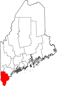
Arundel is a town in York County, Maine, United States. At the 2010 census, the population was 4,022. It is part of the Portland–South Portland–Biddeford, Maine Metropolitan Statistical Area. The Municipality of Arundel includes the constituent communities and neighbourhoods of: Arundel Village, Vinegar Hill, Riverside Arundel, Log Cabin Crossing, Goff Mill, Millers Crossing, and Cottagehill (Cape Arundel Cottage Preserve), among other neighbourhoods in an inland area adjacent to the Towns of Kennebunkport and Biddeford.
Arundel, Maine | |
|---|---|
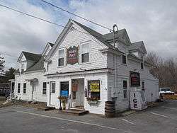
 Winks Place | |
| Motto(s): Where People Matter | |
 Arundel | |
| Coordinates: 43°26′42″N 70°31′15″W | |
| Country | United States |
| State | Maine |
| County | York |
| Incorporated | 1915 |
| Government | |
| • Type | Board of Selectmen |
| • Selectmen | Jason Nedeau, Chair Velma Jones Hayes Phil Labbe Thomas Danylik Dan Dubois |
| • Town Manager | Keith Trefethen |
| Area | |
| • Total | 23.90 sq mi (61.90 km2) |
| • Land | 23.87 sq mi (61.82 km2) |
| • Water | 0.03 sq mi (0.08 km2) |
| Elevation | 105 ft (32 m) |
| Population | |
| • Total | 4,022 |
| • Estimate (2012[3]) | 4,105 |
| • Density | 168.5/sq mi (65.1/km2) |
| Time zone | UTC-5 (Eastern (EST)) |
| • Summer (DST) | UTC-4 (EDT) |
| ZIP code | 04046 |
| Area code(s) | 207 |
| FIPS code | 23-01605 |
| GNIS feature ID | 0582330 |
| Website | www.arundelmaine.org |
History
The area now known as Arundel, while sometimes referred to by that name, was a part of Kennebunkport until 1915, at which point it was set off and named North Kennebunkport. In 1957, following the publication of the Chronicles of Arundel by Kenneth Roberts, the town was renamed Arundel by the state legislature, after Lord Arundel.[4][5]
Geography
According to the United States Census Bureau, the town has a total area of 23.90 square miles (61.90 km2), of which, 23.87 square miles (61.82 km2) of it is land and 0.03 square miles (0.08 km2) is water.[1] Arundel is drained by the Kennebunk River.
The town is crossed by Interstate 95, U.S. Route 1 and state routes 35 and 111. It is bordered by the towns of Kennebunkport to the southeast, Kennebunk to the southwest, Lyman to the northwest, Dayton to the north, and Biddeford to the northeast.
Demographics
| Historical population | |||
|---|---|---|---|
| Census | Pop. | %± | |
| 1790 | 1,458 | — | |
| 1800 | 1,900 | 30.3% | |
| 1810 | 2,371 | 24.8% | |
| 1820 | 2,478 | 4.5% | |
| 1920 | 564 | — | |
| 1930 | 545 | −3.4% | |
| 1940 | 866 | 58.9% | |
| 1950 | 939 | 8.4% | |
| 1960 | 907 | −3.4% | |
| 1970 | 1,322 | 45.8% | |
| 1980 | 2,150 | 62.6% | |
| 1990 | 2,669 | 24.1% | |
| 2000 | 3,571 | 33.8% | |
| 2010 | 4,022 | 12.6% | |
| Est. 2014 | 4,176 | [6] | 3.8% |
| [7][8][9] | |||
2010 census
As of the census[2] of 2010, there were 4,022 people, 1,569 households, and 1,109 families living in the town. The population density was 168.5 inhabitants per square mile (65.1/km2). There were 1,692 housing units at an average density of 70.9 per square mile (27.4/km2). The racial makeup of the town was 96.6% White, 0.4% African American, 0.5% Native American, 0.8% Asian, 0.2% from other races, and 1.5% from two or more races. Hispanic or Latino of any race were 1.0% of the population.
There were 1,569 households of which 31.5% had children under the age of 18 living with them, 57.2% were married couples living together, 8.7% had a female householder with no husband present, 4.8% had a male householder with no wife present, and 29.3% were non-families. 20.8% of all households were made up of individuals and 7.4% had someone living alone who was 65 years of age or older. The average household size was 2.56 and the average family size was 2.96.
The median age in the town was 42.9 years. 22% of residents were under the age of 18; 6.7% were between the ages of 18 and 24; 24.6% were from 25 to 44; 34.7% were from 45 to 64; and 12.2% were 65 years of age or older. The gender makeup of the town was 49.2% male and 50.8% female.
2000 census
As of the census[10] of 2000, there were 3,571 people, 1,363 households, and 999 families living in the town. The population density was 149.3 people per square mile (57.7/km2). There were 1,415 housing units at an average density of 59.2 per square mile (22.8/km2). The racial makeup of the town was 98.26% White, 0.14% African American, 0.45% Native American, 0.39% Asian, 0.06% Pacific Islander, 0.14% from other races, and 0.56% from two or more races. Hispanic or Latino of any race were 0.50% of the population.
There were 1,363 households out of which 35.6% had children under the age of 18 living with them, 61.3% were married couples living together, 8.5% had a female householder with no husband present, and 26.7% were non-families. 19.4% of all households were made up of individuals and 5.9% had someone living alone who was 65 years of age or older. The average household size was 2.61 and the average family size was 3.01.
In the town, 26.1% of the residential population is under the age of 18, 6.2% is from 18 to 24, 32.5% from 25 to 44, 27.1% from 45 to 64, and 8.1% were 65 years of age or older. The median age was 37 years. For every 100 females, there were 97.5 males. For every 100 females age 18 and over, there were 97.0 males.
The median income for a household in the town was $49,484, and the median income for a family was $50,709. Males had a median income of $35,517 versus $25,684 for females. The per capita income for the town was $20,538. About 5.0% of families and 5.4% of the population were below the poverty line, including 9.6% of those under age 18 and 4.5% of those age 65 or over.
Education
Arundel is part of the RSU21 school district which encompasses the Towns of Arundel, Kennebunk, and Kennebunkport.
Mildred L. Day School schools the children of Arundel from the grades kindergarten to fifth grade. After June 30, 2016, students entering grades 6-8, who reside in Arundel will attend Middle School of the Kennebunks. However, by way of a transition Resolution, those students already enrolled in Thornton Academy Middle School and those 5th graders entering grade 6 in the fall of 2016 may notify the Superintendent of Schools by April 15, 2016 requesting they continue their middle school education at Thornton Academy Middle School. Students who live in Arundel and are entering grade 6 in the fall of 2017, and thereafter, will attend Middle School of the Kennebunks, with those students requiring following exceptions:
Alternative placement through an Individual Education Program (I.E.P.) decision. Alternative placement when it would be in a particular child's best interest as determined by the Superintendent or his/her designee. Alternative placement necessary to balance school populations both in numbers and make up determined by the Superintendent or his/her designee.
Adjacent towns
References
- "US Gazetteer files 2010". United States Census Bureau. Retrieved 2012-12-16.
- "U.S. Census website". United States Census Bureau. Retrieved 2012-12-16.
- "Population Estimates". United States Census Bureau. Archived from the original on 2013-06-11. Retrieved 2013-07-06.
- "Profile for Arundel, Maine". ePodunk. Retrieved 2010-05-08.
- Katy Rice, 'Across the Pond', in Sussex Society, September 2011, p. 29
- "Annual Estimates of the Resident Population for Incorporated Places: April 1, 2010 to July 1, 2014". Archived from the original on May 23, 2015. Retrieved June 4, 2015.
- "Population of Counties by Decennial Census: 1900 to 1990". census.gov. Retrieved 2013-01-10.
- "Race, Hispanic or Latino, Age, and Housing Occupancy: 2010 more information". census.gov. Retrieved 2013-01-10.
- "University of Virginia Library". Mapserver.lib.virginia.edu. Retrieved 2013-01-10.
- "U.S. Census website". United States Census Bureau. Retrieved 2008-01-31.
External links
- Town of Arundel, Maine
- Arundel at Maine.gov
- Arundel Elementary School
- City Data Profile
- Epodunk Town Profile
- History of Kennebunkport & Arundel, Maine (1886)
