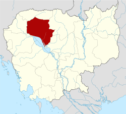
Angkor Thom District
Angkor Thom District (Khmer: ស្រុកអង្គរធំ) is an administrative district of Siem Reap Province, in north western Cambodia. According to the 1998 census of Cambodia, it had a population of 17,750.[1]
Angkor Thom ស្រុកអង្គរធំ | |
|---|---|
District (srok) | |
| Coordinates: 13°26′N 103°51′E | |
| Country | |
| Province | Siem Reap |
| Time zone | +7 |
| Geocode | 1702 |
Administrative divisions
Angkor Thom District a district in Siem Reap. The district has 4 communes and ? villages.
| Code Commune | Commune | Language Khmer | Village |
|---|---|---|---|
| 170201 | Chob Ta Trav | ជប់តាត្រាវ | ត្រពាំងទូក, ជប់, ប្រាសាទ, ទ័ពស្វាយ, ពងទឹក |
| 170202 | Leang Dai | លាងដៃ | លាងដៃ, ដូនឪ, ភ្លង់, តាប្រុក, សំរោង, ត្រពាំងស្វាយ, បំពេញរាជ្យ, ស្ពានថ្មី, គោកគ្រើល |
| 170203 | Peak Snaeng | ពាក់ស្នែង | ពាក់សែ្នងថ្មី, ពាក់សែ្នងចាស់, លៀប, ខី្ទង, សណ្តាន់, ជប់សោម |
| 170204 | Svay Chek | ឃុំស្វាយចេក | គោកកក់, ស្វាយចេក, កណ្តោល, តាត្រាវ, បុស្សតាត្រាវ, ព្រះគោ |
gollark: I ran a server with maybe 50 mods off a Xeon E3-1240 and 4GB of RAM a while ago, and that mostly worked.
gollark: Also, I'd recommend the Foamfix mod, which reduces RAM use a bit.
gollark: Minecraft tends to eat RAM. How much RAM?
gollark: That's doable on some server platforms/
gollark: I vaguely remember playing on a GregTech pack ages ago. I think I got to something like the low-voltage tier before accidentally exploding my base due to a voltage mismatch of some sort and quitting.
References
- "General Population Census of Cambodia 1998, Final Census Results" (PDF). National Institute of Statistics, Ministry of Planning, Cambodia. August 2002. Retrieved 2010-11-25. See page 226.
This article is issued from Wikipedia. The text is licensed under Creative Commons - Attribution - Sharealike. Additional terms may apply for the media files.
