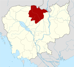
Kuleaen District
Kuleaen District is a district located in Preah Vihear Province, in northern Cambodia. According to the 1998 census of Cambodia, it had a population of 13,829.[2] The population recorded by the 2008 census was 24,824.[1]
Kuleaen គូលែន | |
|---|---|
District (srok) | |
 Kuleaen Location in Cambodia | |
| Coordinates: 13°47′09″N 104°36′38″E | |
| Country | |
| Province | Preah Vihear |
| Communes | 6 |
| Villages | 23 |
| Population (2008)[1] | |
| • Total | 24,824 |
| Time zone | +7 |
| Geocode | 1304 |
Administration
The following table shows the villages of Kuleaen district by commune.
| Khum (Communes) | Phum (Villages) |
|---|---|
| Kuleaen Tboung | Kuleaen Tboung, Krabau |
| Kuleaen Cheung | Kuleaen Cheung, Pyuor Chruk |
| Thmei | Thnal Baek, Trav Kiet, Pongro, Dan, Damnak Kantuot |
| Phnum Penh | Pnov, Bos, Srabal |
| Phnum Tbaeng Pir | Chhuk, Sralay, Baribour, Kdak |
| Srayang | Srayang Cheung, Srayang Tboung, Kaoh Ker, Mrech, Rumchek, Sambour, Sna Pa'ek |
gollark: So, you're hoping people will use NC instead of spamming cheap EIO solar panels.
gollark: Also, people will just use Actually Additions, probably, for power.
gollark: If they make a giant NC reactor, what will they spend power on?
gollark: Gollark's Law: Without encouragement to do otherwise, people will initially go for the easy thing.
gollark: Realistically everyone will use Ender IO.
References
- "2008 Census – Kuleaen District". opendevelopmentcambodia.net. Open Development Cambodia. Retrieved 19 May 2020.
- "General Population Census of Cambodia 1998, Final Census Results" (PDF). National Institute of Statistics, Ministry of Planning, Cambodia. August 2002. p. 184. Retrieved 25 November 2010.
This article is issued from Wikipedia. The text is licensed under Creative Commons - Attribution - Sharealike. Additional terms may apply for the media files.
