Anak Krakatoa
Anak Krakatoa (English: "Child of Krakatoa") is an island in a caldera in the Sunda Strait between the islands of Java and Sumatra in the Indonesian province of Lampung.[1] On December 29, 1927, Anak Krakatoa emerged from the caldera formed in 1883 by the explosive volcanic eruption that destroyed the island of Krakatoa. There has been sporadic eruptive activity at the site since the late 20th century, culminating with a large underwater collapse of the volcano which caused a deadly tsunami in December 2018, followed by subsequent activity in 2019 and an eruption in April 2020. Due to its young age, the island is one of several in the area which are of considerable interest to volcanologists, and the subject of extensive study.
| Anak Krakatoa | |
|---|---|
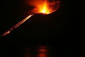
 Anak Krakatoa 2008 eruption | |
| Highest point | |
| Elevation | 110 m (360 ft) |
| Prominence | 110 m (360 ft) |
| Listing | Spesial Ribu |
| Coordinates | 6°06′07″S 105°25′23″E |
| Naming | |
| Native name | Anak Krakatau (Indonesian) |
| Geography | |
 Anak Krakatoa Location | |
| Location | Indonesia |
| Geology | |
| Age of rock | Holocene – very recent |
| Mountain type | Caldera |
| Last eruption | April 2020 |
| Climbing | |
| First ascent | 29 December 1927 |
Activity


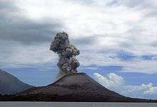
Until its 2018 collapse, Anak Krakatau had grown at 13 cm (5.1 in) per week on average since the 1950s. This equates to an average growth of 6.8 m (22 ft) per year. The island remains active in January 2019, with its most recent eruptive episode having begun in 1994. Quiet periods of a few days have alternated with almost continuous Strombolian eruptions since then. Hot gases, rocks, and lava were released in an eruption in April 2008. Scientists monitoring the volcano warned people to stay out of a 3 km (1.9 mi) zone around the island.[2] On 6 May 2009, the Volcanological Survey of Indonesia raised the eruption alert status of Anak Krakatoa to Level III.[3] An expedition to the volcano revealed that a 100 m (330 ft) wide lava dome was growing in its crater.
In January 2012, volcanologists at the University of Oregon warned that a tsunami caused by flank collapse of Anak Krakatoa was likely, as it had formed on a steep slope at an edge of the big caldera formed in 1883.[4] A new eruptive phase was observed from June 2018, and on 15 October 2018, Anak Krakatau had a strong Strombolian to weak Vulcanian eruption that sent lava bombs into the water, with one almost hitting a nearby boat. The eruption was recorded on video.[5]
2018 eruption and aftermath

An eruption of the volcano on 22 December 2018 caused a deadly tsunami, with waves up to five meters in height making landfall.[6][7] On 31 December 2018, the disaster agency gave the tsunami's death toll as 437, with 14,059 injured.[8] The tsunami affected more than 186 miles of coastline in Sumatra and Java. More than 420 people died, and 40,000 were displaced.[9] This made the eruption the deadliest volcanic eruption of the 21st century so far. Cone collapse—with tsunami generation—was considered a potential hazard immediately before the eruption.[7] Scientists had modeled the possibility six years before the event, and had identified the western flank as the section of the volcano most likely to fail.[7]
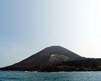
Following the December 2018 eruption, it was believed that the southwest sector of the volcano, including the summit, had collapsed during the eruption, triggering the tsunami. On 23 December, this was confirmed by satellite data and helicopter footage, with the main conduit seen erupting from underwater, producing Surtseyan-style activity.[10] The volcano lost over two-thirds of its volume due to this event, and its elevation above sea level was reduced from 338 m (1,109 ft) to just 110 m (360 ft).[11][7]
Satellite radar observations showed that by 10 January 2019, the volcano had continued to form, with further eruptions beginning to re-model the remnant structure. The crater, which had become open to the sea immediately after the eruption, now had a complete circle of rim above sea level.[12]
In May 2019, phreatomagmatic activity was observed around the newly-reconstructed crater as the volcano continued to increase in height and remodel the areas destroyed in 2018.[13]
2020 eruption

Anak Krakatoa began erupting again on the morning of 10 April 2020. The first eruption could be heard in the Indonesian capital of Jakarta, over 150 kilometres (93 mi) away spewing out a 200 metres (660 ft) high column of ash and smoke according to The Center for Volcanology and Geological Disaster Mitigation’s (PVMBG) magma volcanic activity report said that the first eruption lasted one minute and 12 seconds starting at 9:58 p.m.[14] The eruption spewed ash to about 14 kilometres (46,000 ft) and a secondary ash plume made it to about 11 kilometres (36,000 ft). The eruption was largely magmatic with lava fountains visible. No widespread damage was reported, and the eruption ended several hours later.[15]
See also
References
- Volcano;
- "Indonesia's Krakatau roars, dazzles with fireworks". Reuters India. 11 November 2007. Retrieved 10 January 2019.
- "VSI Alert". Volcanological Survey of Indonesia. Archived from the original on 6 May 2009. Retrieved 20 March 2012.
- Giachetti, T.; Paris, R.; Kelfoun, K.; Ontowirjo, B. (January 2012). Terry, J. P.; Goff, J. (eds.). "Tsunami Hazard Related to a Flank Collapse of Anak Krakatau Volcano, Sunda Strait, Indonesia". Natural Hazards in the Asia–Pacific Region: Recent Advances and Emerging Concepts. Special Publications. London: Geological Society. 361: 79–90. doi:10.1144/SP361.7. ISSN 0305-8719.
- "Tour boat almost lava-bombed by erupting Indonesian volcano in stunning VIDEO". RT. Retrieved 29 October 2018.
- "Indonesia 'Volcano Tsunami': At least 168 Dead and 745 Injured after [Anuk] Krakatoa Erupts". telegraph.co.uk. 23 December 2018. Retrieved 23 December 2018.
- Anak Krakatau: Indonesian Volcano's Dramatic Collapse"; article; 29 December 2018; Amos, Jonathan; BBC Science Correspondent; BBC News, Science & Environment; accessed September 2019
- "Number of injured in Indonesia tsunami surges to over 14,000". The Star Online. Asean Plus. Retrieved 31 December 2018.
- Anak Krakatau Volcano Triggered Deadly Tsunami; article; Dec. 29, 2018, 4:21 AM EST; Associated Press; accessed September 2019
- "22-23 Dec 2018 Eruption & Tsunami of Krakatoa - Updates". Volcano Discovery. 25 December 2018. Retrieved 26 December 2018.
- Amos, Jonathan (29 December 2018). "Indonesian volcano's lost stature". BBC News. Retrieved 29 December 2018.
- "Anak Krakatau: Finnish radar satellite eyes tsunami volcano". BBC News. 10 January 2019. Retrieved 10 January 2019.
- "Krakatau volcano (Indonesia) activity update and field report: increasing unrest". Volcano Discovery.
- https://www.thejakartapost.com/news/2020/04/11/anak-krakatau-erupts-loud-rumble-heard-in-virus-stricken-greater-jakarta.html. Missing or empty
|title=(help) - "Eruption at Indonesian volcano Krakatoa". Newshub. Retrieved 11 April 2020.
External links
