Altaghoney
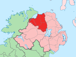
Altaghoney (from Irish: Alt a Chonnaidh, meaning "glen of the firewood")[1] is townland of 1,163 acres in County Londonderry, Northern Ireland. It is situated in the civil parish of Cumber Upper and the historic barony of Tirkeeran.[2]
Altaghoney
| |
|---|---|
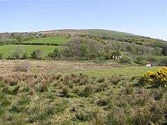 Altaghoney townland in 2007 | |
| County | |
| Country | Northern Ireland |
| Sovereign state | United Kingdom |
| Postcode district | BT47 |
| Dialling code | 028 |
Archaeology
Altaghoney contains a stone circle at grid ref: C515013.[3] It also contains a cross at grid ref: C5371 0192 which is registered as a Scheduled Historic Monument.[4]
gollark: But it'll still be broken.
gollark: If you're so good at making Macron and addressing things, you can do it. You might want the Cargo.toml.
gollark: I mean, I can cast them to raw pointers, but then not use them.
gollark: I can't just "address" things. This is Rust. It is a HIGH LEVEL memory SAFE language.
gollark: I am asking YOU to fix it.
References
- "Altaghoney". Place Names NI. Retrieved 10 May 2015.
- "Altaghoney". IreAtlas Townlands Database. Retrieved 10 May 2015.
- "Altaghoney Stone Circle". The Megalithic Portal. Retrieved 10 May 2015.
- "Altaghoney" (PDF). Scheduled Historic Monuments. Northern Ireland Environment Agency. Archived from the original (PDF) on 27 April 2015. Retrieved 10 May 2015.
| Wikimedia Commons has media related to Altaghoney. |
This article is issued from Wikipedia. The text is licensed under Creative Commons - Attribution - Sharealike. Additional terms may apply for the media files.