Albertville, Quebec
Albertville is a municipality in the Canadian province of Quebec, located in La Matapédia Regional County Municipality.
Albertville | |
|---|---|
Municipality | |
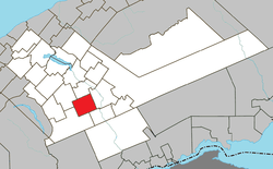
 Location within La Matapédia RCM. | |
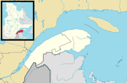
 Albertville Location in eastern Quebec. | |
| Coordinates: 48°19′N 67°22′W[1] | |
| Country | |
| Province | |
| Region | Bas-Saint-Laurent |
| RCM | La Matapédia |
| Settled | 1899 |
| Constituted | November 29, 1930 |
| Government | |
| • Mayor | Martin Landry |
| • Federal riding | Avignon—La Mitis—Matane—Matapédia |
| • Prov. riding | Matane-Matapédia |
| Area | |
| • Total | 104.71 km2 (40.43 sq mi) |
| • Land | 103.57 km2 (39.99 sq mi) |
| Population (2016)[3] | |
| • Total | 226 |
| • Density | 2.2/km2 (6/sq mi) |
| • Pop 2011–2016 | |
| • Dwellings | 126 |
| Time zone | UTC−5 (EST) |
| • Summer (DST) | UTC−4 (EDT) |
| Postal code(s) | G0J 1A0 |
| Area code(s) | 418 and 581 |
| Highways | No major routes |
| Website | www |
The municipality had a population of 226 in the Canada 2016 Census.
Geography
Albertville is in one of the highest territories of the Matapédia Valley.[1]
Demographics
Population
| Canada census – Albertville, Quebec community profile | |||
|---|---|---|---|
| 2011 | 2006 | ||
| Population: | 256 (-19.7% from 2006) | 319 (-5.3% from 2001) | |
| Land area: | 102.27 km2 (39.49 sq mi) | 102.27 km2 (39.49 sq mi) | |
| Population density: | 2.5/km2 (6.5/sq mi) | 3.1/km2 (8.0/sq mi) | |
| Median age: | 48.0 (M: 47.3, F: 48.6) | 42.5 (M: 43.9, F: 41.3) | |
| Total private dwellings: | 146 | 133 | |
| Median household income: | $39,187 | ||
| Notes: 2011 income data for this area has been suppressed for data quality or confidentiality reasons. – References: 2011[4] 2006[5] earlier[6] | |||
Canada Census data before 2001:[7]
- Population in 1996: 364 (-9.0% from 1991)
- Population in 1991: 400
Municipal council
- Mayor: Martin Landry
- Councillors: Edes Berger, Géraldine Chrétien, Charline Chabot, Gilles Demeules, Roger Durette, Gilberte Potvin
gollark: My poor, defenceless liver!
gollark: Hmm yes, I too enjoy interacting with friends while frying my brain and liver somewhat.
gollark: Alcohol bad (although people should be allowed to use it still, obviously, if they find it fun or something).
gollark: For *basically everyone*, it does muck with reflexes and decision making.
gollark: Also reflexes and stuff, so you can't respond to cars fast enough.
See also
References
- Reference number 333996 of the Commission de toponymie du Québec (in French)
- Geographic code 07025 in the official Répertoire des municipalités (in French)
- "(Code 2407025) Census Profile". 2016 census. Statistics Canada. 2017.
- "2011 Community Profiles". 2011 Canadian Census. Statistics Canada. July 5, 2013. Retrieved 2013-05-12.
- "2006 Community Profiles". 2006 Canadian Census. Statistics Canada. March 30, 2011. Retrieved 2014-02-01.
- "2001 Community Profiles". 2001 Canadian Census. Statistics Canada. February 17, 2012.
- Statistics Canada: 1996 census
| Wikimedia Commons has media related to Albertville, Quebec. |
This article is issued from Wikipedia. The text is licensed under Creative Commons - Attribution - Sharealike. Additional terms may apply for the media files.