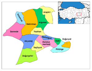
Akçadağ
Akçadağ (Kurdish: Arxa)[3] is a district of Malatya Province of Turkey. The mayor is Ali Kazgan (AKP).
Akçadağ, (Arabic: Arga), | |
|---|---|
 Akçadağ, (Arabic: Arga), | |
| Coordinates: 38°20′42″N 37°58′07″E | |
| Country | |
| Province | Malatya |
| Government | |
| • Mayor | Ali Kazgan (AKP) |
| • Kaymakam | Erhan Günay |
| Area | |
| • District | 1,187.54 km2 (458.51 sq mi) |
| Population (2012)[2] | |
| • Urban | 7,055 |
| • District | 28,206 |
| • District density | 24/km2 (62/sq mi) |
| Post code | 446xx |
| Website | [www.akcadag.gov.tr YerelNet].</ref> |
History
Settlement in and around Akçadağ dates to the Bronze Age. The Hittite, Roman and Byzantine empire have all left their trace. Akçadağ was one of the first towns to be settled by Turks in Anatolia with a garrison of Turk mercenaries placed here by the Byzantine crown anxious at Muslim-Arab incursions.
Akçadağ came under Ottoman control during the reign of Abdülhamit.
On 24 Jan 2020 the town was impacted by a magnitude 6.7 earthquake.[4][5]
Economy
The Akçadağ has 2 districts, Kürecik and Levent, 4 municipalities, Akçadağ center, Bahri, Ören and Yukarı Kozluca, 9 neighborhoods, 72 villages and 169 hamlets. Agriculture is important to the local economy with 75% of the population engaged in agricultureal production, and although the area produces a wide range of agricultural products, apricots and racing horses are of particular importance and note. The literacy rate in Akçadağ is estimated at 98%.
Administration
The District governor is Serdar Demirhan[6] and the towns mayor is Ali Kazgan an Independent.
Geography
Akçadağ is at an Altitude of 1,050 m (3,440 ft) above sea level and the district is considered mountainous, and the population is 2016 was 26.561.
See also
- Kürecik Radar Station, a NATO early-warning missile defense radar situated at Çat Tepe in Kürecik.[7]
References
- "Area of regions (including lakes), km²". Regional Statistics Database. Turkish Statistical Institute. 2002. Retrieved 2013-03-05.
- "Population of province/district centers and towns/villages by districts - 2012". Address Based Population Registration System (ABPRS) Database. Turkish Statistical Institute. Retrieved 2013-02-27.
- adem Avcıkıran (2009). Kürtçe Anamnez Anamneza bi Kurmancî (PDF) (in Turkish and Kurdish). p. 55. Retrieved 17 December 2019.
- 6.7 magnitude earthquake 5 km from Doğanyol, Malatya, Turkey.
- Recent Earthquakes Near Doğanyol, Malatya, Turkey .
- 1
- "Kürecik'te 40 yıl önce ne oldu?". Vatan (in Turkish). 7 March 2012. Retrieved 10 July 2019.
