Aderklaa
Aderklaa is a town in the district of Gänserndorf in Lower Austria in Austria.
Aderklaa | |
|---|---|
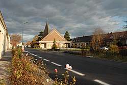
 Church in the center of the village | |
 Coat of arms | |
 Aderklaa Location within Austria | |
| Coordinates: 48°17′N 16°32′E | |
| Country | Austria |
| State | Lower Austria |
| District | Gänserndorf |
| Government | |
| • Mayor | Bernhard Wolfram (ÖVP) |
| Area | |
| • Total | 8.63 km2 (3.33 sq mi) |
| Elevation | 157 m (515 ft) |
| Population (2018-01-01)[2] | |
| • Total | 207 |
| • Density | 24/km2 (62/sq mi) |
| Time zone | UTC+1 (CET) |
| • Summer (DST) | UTC+2 (CEST) |
| Postal code | 2232 |
| Area code | 02247 |
Geography
Aderklaa lies in the Marchfeld in Lower Austria between Vienna and Deutsch Wagram. About 1.22 percent of the municipality is forested.
gollark: It's kind of funny that the entire RPi3 GPU has less throughput than a single core of my CPU.
gollark: Exactly.
gollark: > The VideoCore IV GPU, in the configuration as found in the Raspberry Pi models, has a theoretical maximum performance of 24 GPFLOS and is therefore very powerful in comparison to the host CPU. The GPU (which is located on the same chip as the CPU) has 12 cores, able of running independent instructions each, supports a SIMD vector-width of 16 elements natively and can access the RAM directly via DMA.So obviously ALL should write code for the VC4.
gollark: Good ideaeae!
gollark: How come it only has CPU architectures? It should run on GPUs too.
References
- "Dauersiedlungsraum der Gemeinden Politischen Bezirke und Bundesländer - Gebietsstand 1.1.2018". Statistics Austria. Retrieved 10 March 2019.
- "Einwohnerzahl 1.1.2018 nach Gemeinden mit Status, Gebietsstand 1.1.2018". Statistics Austria. Retrieved 9 March 2019.
This article is issued from Wikipedia. The text is licensed under Creative Commons - Attribution - Sharealike. Additional terms may apply for the media files.