2010 Papua earthquake
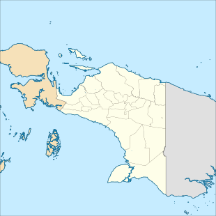
The 2010 Papua earthquake occurred on June 16 at 12:16 local time (03:16 UTC) in Papua province of Indonesia. The magnitude 7.0 mainshock was preceded by an Mw 6.2 foreshock 10 minutes earlier, and was followed 42 minutes later by an Mw 6.6 aftershock.
  | |
| UTC time | 2010-06-16 03:16:27 |
|---|---|
| ISC event | 600181845 |
| USGS-ANSS | ComCat |
| Local date | June 16, 2010 |
| Local time | 12:16 |
| Magnitude | 7.0 Mw |
| Depth | 15 km (9 mi) [1] |
| Epicenter | 2.22°S 136.58°E [1] |
| Areas affected | Indonesia, Papua |
| Foreshocks | 6.2 Mw June 16 at 03:06:03 |
| Aftershocks | 6.6 Mw June 16 at 03:58:09 |
| Casualties | 17 killed |
Geology
This part of Indonesia is an area of complex tectonics. The epicenter of the earthquake lies close to the boundary between two proposed microplates, the Bird's Head and Maoke microplates. The motion along this boundary has been modelled as about 80 mm/year sinistral (left lateral) strike-slip. The computed focal mechanism is consistent either with movement on this boundary or on a dextral (right lateral) strike-slip structure conjugate to it.[2]
Damage
The earthquake destroyed nine villages, namely Aiyari, Randawaya, Hamtimoi, Karowaiti, Waita, Waridoni, Tare, Larelahiti and Wabudayar,[3] and killed 17 people.[2][4] More than 2,500 houses were destroyed.[5] While Mercalli intensities of VI (Strong) affected the island of Biak, intensities of more than VII (Very strong) affected Serui (on Yapen) and on the neighbouring coast of the mainland.[6] Many buildings were damaged on Yapen Island.[7][8]
References
- ISC (19 January 2015), ISC-GEM Global Instrumental Earthquake Catalogue (1900–2009), Version 2.0, International Seismological Centre
- USGS (16 June 2010). "Magnitude 7.0 - NEAR THE NORTH COAST OF PAPUA, INDONESIA". Retrieved 19 June 2010.
- "Papua Earthquake Destroys Nine Villages; Homeless in Need of Aid". Jakarta Globe. Antara. 17 June 2010. Archived from the original on 24 February 2012.
- "Indonesian earthquake death toll climbs to 17". CNN. 21 June 2010. Archived from the original on 25 June 2010. Retrieved 22 June 2010.
- "Powerful quake that struck Indonesia's Papua province leaves at least 17 dead". The Australian. 21 June 2010. Retrieved 23 June 2010.
- Badan Meteorologi Klimatologi dan Geofisika (18 June 2010). "PETA ISOSEISMAL GEMPABUMI BIAK 7.1 S.R TANGGAL 16 JUNI 2010" [Isoseismal map for the 7.1 ML Biak earthquake 16 June 2010] (in Indonesian). Archived from the original on 16 July 2011. Retrieved 19 June 2010.
- "Strong quakes rock eastern Indonesia; 3 dead". NBC News. Associated Press, Reuters. 16 June 2010. Retrieved 19 December 2016.
- Pelu, Sali (16 June 2010). "Earthquakes kill three in Indonesia". Brisbane Times. Agence France-Presse. Retrieved 19 December 2016.
External links
- Rnzi.com: "Indonesia Yapen Quake death toll rises to 22"
- The International Seismological Centre has a bibliography and/or authoritative data for this event.