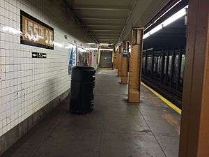
155th Street station (IND Eighth Avenue Line)
155th Street is a local station on the IND Eighth Avenue Line of the New York City Subway. Located under the intersection of 155th Street and St. Nicholas Avenue, at the border of the Harlem and Washington Heights neighborhoods of Manhattan, it is served by the C train at all times except nights, when the A train takes over service.
155 Street | |||||||||
|---|---|---|---|---|---|---|---|---|---|
 Brooklyn bound platform | |||||||||
| Station statistics | |||||||||
| Address | West 155th Street & St. Nicholas Avenue New York, NY 10032 | ||||||||
| Borough | Manhattan | ||||||||
| Locale | Washington Heights, Hamilton Heights, Harlem | ||||||||
| Coordinates | 40.830859°N 73.9414°W | ||||||||
| Division | B (IND) | ||||||||
| Line | IND Eighth Avenue Line | ||||||||
| Services | A C | ||||||||
| Transit connections | |||||||||
| Structure | Underground | ||||||||
| Platforms | 2 side platforms | ||||||||
| Tracks | 2 | ||||||||
| Other information | |||||||||
| Opened | September 10, 1932[1] | ||||||||
| Station code | 150[2] | ||||||||
| Wireless service | |||||||||
| Opposite-direction transfer available | Yes | ||||||||
| Traffic | |||||||||
| Passengers (2019) | 895,036[4] | ||||||||
| Rank | 373 out of 424[4] | ||||||||
| Station succession | |||||||||
| Next north | 163rd Street–Amsterdam Avenue: A | ||||||||
| Next south | 145th Street: A | ||||||||
| |||||||||
| |||||||||
| |||||||||
Station layout
| G | Street level | Exit/entrance |
| B1 | Mezzanine | Fare control, station agent |
| B2 Platform level |
Side platform | |
| Northbound local | ← ← | |
| Southbound local | | |
| Side platform | ||
| B3[5] | Northbound express | ← |
| Southbound express | | |
The station opened on September 10, 1932, as part of the city-operated Independent Subway System (IND)'s initial segment, the Eighth Avenue Line between Chambers Street and 207th Street.[1][6] It has two local tracks with two side platforms. Two express tracks, used by the A train during daytime hours, run below the station and are not visible from the platforms.[7]
The station once had a southern mezzanine with exits to 153rd Street, but it is now closed and used as a MTA New York City Transit facility.[8] The north end at 155th Street has vent chambers and a high ceiling.
Exits
References
- "List of the 28 Stations on the New 8th Av. Line". The New York Times. September 10, 1932. p. 6. ISSN 0362-4331. Retrieved April 21, 2020.
- "Station Developers' Information". Metropolitan Transportation Authority. Retrieved June 13, 2017.
- "NYC Subway Wireless – Active Stations". Transit Wireless Wifi. Retrieved November 13, 2019.
- "Facts and Figures: Annual Subway Ridership 2014–2019". Metropolitan Transportation Authority. 2020. Retrieved May 26, 2020.
- "C Train". Station Reporter. Archived from the original on March 13, 2013.
- Crowell, Paul (September 10, 1932). "Gay Midnight Crowd Rides First Trains In The New Subway: Throngs at Station an Hour Before Time, Rush Turnstiles When Chains are Dropped" (PDF). The New York Times. Retrieved November 8, 2015.
- Dougherty, Peter (2006) [2002]. Tracks of the New York City Subway 2006 (3rd ed.). Dougherty. OCLC 49777633 – via Google Books.
- Review of the A and C Lines (PDF) (Report). Metropolitan Transportation Authority. December 11, 2015. Archived from the original (PDF) on February 3, 2020. Retrieved January 19, 2016.
- "MTA Neighborhood Maps: Harlem / Hamilton Heights" (PDF). mta.info. Metropolitan Transportation Authority. 2018. Retrieved October 1, 2018.
External links
| Wikimedia Commons has media related to 155th Street (IND Eighth Avenue Line). |
- nycsubway.org – IND 8th Avenue: 155th Street
- Station Reporter — C Train
- The Subway Nut — 155th Street Pictures
- 155th Street southwestern corner entrance from Google Maps Street View
- Platforms from Google Maps Street View


%26groups%3D_c822f4c15402022218d454b87ab086b1262bf24b.svg)