Ōkura, Yamagata
Ōkura (大蔵村, Ōkura-mura) is a village in Yamagata Prefecture, Japan. As of January 2020, the village has an estimated population of 3044, and a population density of 14 persons per km2. The total area is 211.59 square kilometres (82 sq mi).
Ōkura 大蔵村 | |
|---|---|
Village | |
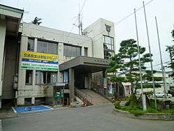 Ōkura Village Hall | |
 Flag  Seal | |
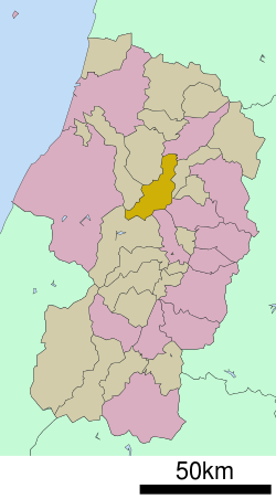 Location of Ōkura in Yamagata Prefecture | |
 Ōkura | |
| Coordinates: 38°42′14.8″N 140°13′49.3″E | |
| Country | Japan |
| Region | Tōhoku |
| Prefecture | Yamagata |
| District | Mogami |
| Area | |
| • Total | 211.59 km2 (81.70 sq mi) |
| Population (January 2020) | |
| • Total | 3,044 |
| • Density | 14/km2 (37/sq mi) |
| Time zone | UTC+9 (Japan Standard Time) |
| City symbols | |
| • Tree | Japanese beech |
| • Flower | Japanese gentian |
| • Bird | Copper pheasant |
| Phone number | 0233-75-2111 |
| Address | 2528 Kiyomizu, Ōkura-mura, Mogami-gun, Yamagata-ken 999-0212 |
| Website | Official website |
Geography
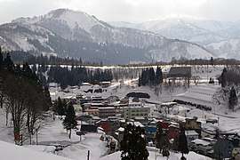
Ōkura is located in a mountainous north-central eastern Yamagata Prefecture, and includes Mount Gassan within its borders. The Mogami River runs through the village. The area is known for extremely heavy snows in winter. Its highest accumulation of snow recorded is 414 cm, second place in Japan after Sukayu Onsen in Aomori. Snow typically starts in November, and starts piling up on the ground by early December. The snow will usually stop by early May, but will not completely melt until mid-June. Similar to Sukayu Onsen, snowfalls of 50 to 100 cm in a single day are not uncommon at all.
Demographics
Per Japanese census data,[1] the population of Ōkura peaked in the 1950s, and is now considerably less than what it was a century ago.
| Year | Pop. | ±% |
|---|---|---|
| 1920 | 8,156 | — |
| 1930 | 7,486 | −8.2% |
| 1940 | 7,797 | +4.2% |
| 1950 | 9,015 | +15.6% |
| 1960 | 8,434 | −6.4% |
| 1970 | 6,080 | −27.9% |
| 1980 | 5,301 | −12.8% |
| 1990 | 4,982 | −6.0% |
| 2000 | 4,528 | −9.1% |
| 2010 | 3,762 | −16.9% |
Climate
Ōkura has a Humid continental climate (Köppen climate classification Cfa) with large seasonal temperature differences, with warm to hot (and often humid) summers and cold (sometimes severely cold) winters. Precipitation is significant throughout the year, but is heaviest from August to October. The average annual temperature in Ōkura is 9.9 °C. The average annual rainfall is 1795 mm with September as the wettest month. The temperatures are highest on average in August, at around 23.7 °C, and lowest in January, at around -2.7 °C.[2]
History
The area of present-day Ōkura was part of ancient Dewa Province. During the Sengoku period, the area was under the control of the Mogami clan. During the Edo period, the village was a river port on the Mogami River and a post station on the pilgrimage route to Mount Gassan. After the start of the Meiji period, the area became part of Mogami District, Yamagata Prefecture. The village of Ōkura was established on April 1, 1889 with the establishment of the modern municipalities system.
Economy
The main industry is agriculture (tomato and buckwheat), sake production, and seasonal tourism to its hot spring resorts. Kokeshi dolls are a noted local handicraft.
Education
Ōkura has one public elementary school and one public middle school operated by the village government. The village does not have a high school.
Transportation
Railways
Ōkura does not have any passenger railway service.
Highways
Local attractions
- ruins of Shimizu Castle
- Hijiori hot springs
References
External links
| Wikimedia Commons has media related to Okura, Yamagata. |
- Official Website (in Japanese)
Yamagata (capital) | ||
| Core city | ||
| Cities | ||
| Districts | ||
| Authority control |
|
|---|