Kaminoyama
Kaminoyama (上山市, Kaminoyama-shi) is a city located in Yamagata Prefecture, Japan. As of 31 January 2020, the city had an estimated population of 14,358 in 11299 households,[1] and a population density of 120 persons per km2. The total area of the city is 240.93 square kilometres (93 sq mi).
Kaminoyama 上山市 | |
|---|---|
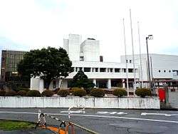 Kaminoyama City Hall | |
 Flag  Seal | |
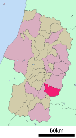 Location of Kaminoyama in Yamagata Prefecture | |
 Kaminoyama | |
| Coordinates: 38°8′58.5″N 140°16′4.3″E | |
| Country | Japan |
| Region | Tōhoku |
| Prefecture | Yamagata |
| Area | |
| • Total | 240.93 km2 (93.02 sq mi) |
| Population (February 2015) | |
| • Total | 29,974 |
| • Density | 120/km2 (320/sq mi) |
| Time zone | UTC+9 (Japan Standard Time) |
| City symbols | |
| - Tree | Japanese yew |
| - Flower | Chrysanthemum |
| - Bird | Little egret |
| Phone number | 023-672-1111 |
| Address | 1-1-10 Kawasaki, Kaminoyama-shi, Yamagata-ken 999-3192 |
| Website | Official website |
.jpg)
Geography
Kaminoyama is located in southeast Yamagata Prefecture, in the Murayama Basin, bordered by Miyagi Prefecture to the east. Mount Zaō is located within its borders.
Neighboring municipalities
- Yamagata Prefecture
- Yamagata, Yamagata
- Nanyo, Yamagata
- Takahata, Yamagata
- Miyagi Prefecture
Demographics
Per Japanese census data,[2] the population of Kaminoyama has gradually been increasing over the past 40 years.
| Year | Pop. | ±% |
|---|---|---|
| 1960 | 40,383 | — |
| 1970 | 38,357 | −5.0% |
| 1980 | 38,533 | +0.5% |
| 1990 | 38,327 | −0.5% |
| 2000 | 36,886 | −3.8% |
| 2010 | 33,743 | −8.5% |
Climate
Kaminoyama has a Humid continental climate (Köppen climate classification Cfa) with large seasonal temperature differences, with warm to hot (and often humid) summers and cold (sometimes severely cold) winters. Precipitation is significant throughout the year, but is heaviest from August to October. The average annual temperature in Kaminoyama is 11.4 °C. The average annual rainfall is 1362 mm with September as the wettest month. The temperatures are highest on average in August, at around 24.9 °C, and lowest in January, at around -1.1 °C.[3]
History
The area of present-day Kaminoyama was part of ancient Dewa Province, and was a castle town for Kaminoyama Domain under the Tokugawa shogunate in the Edo period. It was also a post station on the Ushū Kaidō highway. After the start of the Meiji period, the area became part of Minamimurayama District, Yamagata Prefecture. The town of Kaminoyama was established on April 1, 1889 with the establishment of the modern municipalities system, and was elevated to city status on October 1, 1954.
Government
Higashine has a mayor-council form of government with a directly elected mayor and a unicameral city legislature of 15 members. The city contributes one member to the Yamagata Prefectural Assembly. In terms of national politics, the city is part of Yamagata District 1 of the lower house of the Diet of Japan.
Economy
The economy of Kaminoyama is based on agriculture (horticulture), light manufacturing (electronics, automotive components, clothing, foodstuffs), forestry and tourism.
Education
Kaminoyama has five public elementary schools and three public middle schools operated by the city government and one public high schools operated by the Yamagata Prefectural Board of Education. The prefecture also operates one special education school for the handicapped and two vocational training schools.
Transportation
Railway
![]()
- Kaminoyama Onsen
![]()
- Kaminoyama Onsen - Uzen-Nakayama - Mokichi Kinenkan-mae
Highways
.png)


Local attractions
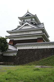
- Kaminoyama Castle
- Sky Tower 41
- Saito Mokichi Memorial Museum
- Kaminoyama Onsen
International relations
Twin towns — Sister cities

Notable people from Kaminoyama
- Masaru Akiba, professional soccer player
- Toshiaki Endo, politician
- Takeshi Koike, anime movie director, illustrator
- Mokichi Saitō, poet [5]
References
- Kaminoyama City official statistics (in Japanese)
- Kaminoyama population statistics
- Kaminoyama climate data
- "Kaminoyama, Japan". official home page. Donaueschingen City. Retrieved 16 December 2015.
- [Heinrich, Amy Vladeck, 1983. Fragments of Rainbows: The Life and Poetry of Saitō Mokichi. New York: Columbia University Press. ISBN 978-0231054287, page 3
External links
| Wikimedia Commons has media related to Kaminoyama, Yamagata. |
- Official Website (in Japanese)
Yamagata (capital) | ||
| Core city | ||
| Cities | ||
| Districts | ||
| Authority control |
|
|---|