Ōgaki
Ōgaki (大垣市, Ōgaki-shi) is a city located in Gifu, Japan. As of 31 October 2018, the city had an estimated population of 161,539, and a population density of 782 persons per km2 in 65,931 households.[1] The total area of the city was 206.57 square kilometres (79.76 sq mi). Ōgaki was the final destination for the haiku poet Matsuo Bashō on one of his long journeys as recounted in his book Oku no Hosomichi. Every November the city holds a Bashō Festival.
Ōgaki 大垣市 | |
|---|---|
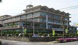
 Ōgaki City Hall | |
 Flag  Seal | |
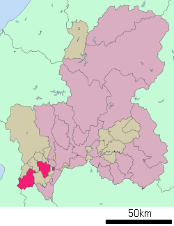
 Location of Ōgaki in Gifu Prefecture | |
 Ōgaki | |
| Coordinates: 35°21′33.7″N 136°36′46.3″E | |
| Country | Japan |
| Region | Chūbu |
| Prefecture | Gifu |
| Area | |
| • Total | 206.57 km2 (79.76 sq mi) |
| Population (December 31, 2018) | |
| • Total | 161,539 |
| • Density | 780/km2 (2,000/sq mi) |
| Time zone | UTC+9 (Japan Standard Time) |
| City symbols | |
| - Tree | Cinnamomum camphora |
| - Flower | Satsuki azalea |
| Phone number | 0584-81-4111 |
| Address | 2-29 Marunouchi, Ōgaki-shi, Gifu-ken 503-8601 |
| Website | Official website |

Geography
Ōgaki is located in the northwest area of the Nōbi Plain in Gifu Prefecture and is known as being the most centrally-located city in Japan. As a result of its 2006 merger with the town of Kamiishizu (from Yōrō District), and the town of Sunomata (from Anpachi District), the city consists of three disconnected regions, with Sunomata in the east, the original Ōgaki in the center, and Kamiishizu in the southwest.[2]
The main river flowing through the city is the Ibi River; however, the Nagara River forms the border between Ōgaki and the neighboring cities of Gifu and Hashima.
Neighbouring municipalities
- Gifu Prefecture
- Gifu
- Hashima
- Mizuho
- Anpachi, Gōdo and Wanouchi (Anpachi District)
- Ikeda (Ibi District)
- Sekigahara and Tarui (Fuwa District)
- Yōrō (Yōrō District)
- Mie Prefecture
- Shiga Prefecture
Demographics
Per Japanese census data,[3] the population of Ōgaki has increased gradually over the past 40 years..
| Census Year | Population |
|---|---|
| 1970 | 147,764 |
| 1980 | 156,215 |
| 1990 | 160,483 |
| 2000 | 161,827 |
| 2010 | 161,160 |
Climate
The city has a climate characterized by characterized by hot and humid summers, and mild winters (Köppen climate classification Cfa). The average annual temperature in Ōgaki is 14.8 °C. The average annual rainfall is 1871 mm with September as the wettest month. The temperatures are highest on average in August, at around 27.2 °C, and lowest in January, at around 3.7 °C.[4]
| Climate data for Ōgaki | |||||||||||||
|---|---|---|---|---|---|---|---|---|---|---|---|---|---|
| Month | Jan | Feb | Mar | Apr | May | Jun | Jul | Aug | Sep | Oct | Nov | Dec | Year |
| Record high °C (°F) | 16.0 (60.8) |
19.7 (67.5) |
25.2 (77.4) |
29.7 (85.5) |
33.1 (91.6) |
35.9 (96.6) |
38.7 (101.7) |
38.7 (101.7) |
36.4 (97.5) |
30.7 (87.3) |
25.1 (77.2) |
19.4 (66.9) |
38.7 (101.7) |
| Average high °C (°F) | 8.3 (46.9) |
9.4 (48.9) |
13.2 (55.8) |
19.5 (67.1) |
23.9 (75.0) |
27.3 (81.1) |
30.9 (87.6) |
32.8 (91.0) |
28.6 (83.5) |
22.9 (73.2) |
16.9 (62.4) |
11.3 (52.3) |
20.4 (68.7) |
| Average low °C (°F) | 1.2 (34.2) |
1.4 (34.5) |
4.3 (39.7) |
9.6 (49.3) |
14.6 (58.3) |
19.2 (66.6) |
23.3 (73.9) |
24.4 (75.9) |
20.6 (69.1) |
14.3 (57.7) |
8.3 (46.9) |
3.4 (38.1) |
12.1 (53.7) |
| Record low °C (°F) | −5.3 (22.5) |
−7.0 (19.4) |
−4.5 (23.9) |
0.9 (33.6) |
6.5 (43.7) |
13.0 (55.4) |
17.0 (62.6) |
17.9 (64.2) |
11.6 (52.9) |
4.5 (40.1) |
−0.2 (31.6) |
−3.8 (25.2) |
−7.0 (19.4) |
| Average precipitation mm (inches) | 67.8 (2.67) |
81.9 (3.22) |
141.0 (5.55) |
168.0 (6.61) |
213.4 (8.40) |
268.5 (10.57) |
278.1 (10.95) |
161.8 (6.37) |
227.2 (8.94) |
130.3 (5.13) |
89.0 (3.50) |
57.9 (2.28) |
1,884.9 (74.19) |
| Average precipitation days (≥ 1.0 mm) | 9.8 | 9.1 | 10.6 | 10.1 | 11.0 | 12.3 | 13.7 | 9.6 | 11.6 | 8.6 | 7.6 | 9.3 | 123.3 |
| Mean monthly sunshine hours | 129.9 | 138.8 | 170.1 | 187.3 | 189.6 | 155.6 | 163.3 | 196.3 | 152.2 | 156.7 | 137.3 | 133.1 | 1,910.2 |
| Source: Japan Meteorological Agency | |||||||||||||
History
The area around Ōgaki was part of traditional Mino Province. During the Edo period, the area developed as a castle town for Ōgaki Domain under the Tokugawa shogunate. In the post-Meiji restoration cadastral reforms, the town of Ogaki was established within Anpachi District, Gifu Prefecture with the creation of the modern municipalities system on July 1, 1889. It was raised to city status on April 1, 1918. The city suffered severe flooding during the 1934 Muroto typhoon, and was largely destroyed in six air raids in 1945.
Municipal timeline
- April 1918: Gained city status
- April 1928: Merged with parts of the village of Kitakuise, Anpachi District (specifically the localities of Kido, Minamiisshiki, Kasagi, Kasanui and Gama)
- December 1934: Merged with village of Minamikuise, Anpachi District
- June 1935: Merged with village of Tagishima, Anpachi District
- June 1936: Merged with village of Yasui, Anpachi District
- February 1940: Merged with villages of Urū and Shizusato, Fuwa District
- October 1947: Merged with villages of Ayasato, Fuwa District, and Sumoto, Anpachi District
- June 1948: Merged with village of Asakusa, Anpachi District
- October 1948: Merged with village of Kawanami and the Maze part of Maki, Anpachi District
- April 1949: Merged with village of Nakagawa, Anpachi District
- April 1951: Merged with village of Wagō, Anpachi District
- June 1952: Merged with village of Mitsukoshi, Anpachi District
- October 1954: Merged with village of Arasaki, Fuwa District
- September 1967: Merged with town of Akasaka, Fuwa District
- April 1988: Established city constitution
- March 27, 2006: Merged with towns of Kamiishizu, Yōrō District, and Sunomata, Anpachi District[2]
Government
Ōgaki has a mayor-council form of government with a directly elected mayor and a unicameral city legislature of 22 members.
Education
Universities and colleges
- Institute of Advanced Media Arts and Sciences (IAMAS)
- Gifu Keizai University
- Ogaki Women's College
- Institute for Fashion Studies (IFS)
- Ogaki Nursing College (moved to Ogaki Medical Association March 31, 2006)
- Nihon Information Processing College
- Nihon General Business College
- Nihon-Chūō Nursing College Ogaki
- Nihon-Chūō Gakuen Culinary College
Primary and secondary education
Ōgaki has 22 public elementary schools and ten public middle schools operated by the city government and one private middle school. The city has nine public high school operated by the Gifu Prefectural Board of Education, and two private high schools. The prefecture also operates one special education school.
- Ogaki Kita Senior High School[6]
- Ogaki Higashi Senior High School
- Ogaki Minami Senior High School
- Ogaki Nishi Senior High School
- Ogaki Technical High School
- Ogaki-Shogyo Business High School[7]
- Nihon University Ogaki Senior High School
- Hirano Gakuen
- Ogaki Sakura High School
- Ogaki School for Handicapped (primary through senior high)
International schools
- Escola Brasileira Prof. Kawase - Brazilian primary school[8]
Transportation
Railway
.svg.png)
- Ōgaki - Arao - Mino-Akasaka


- Ōtoba - Tomoe - Mino-Yanagi - Nishi-Ōgaki - Ōgaki - Muro - Kita-Ōgaki
- Seino Railway (freight railway)
- Seino Ichihashi Line: Mino Akasaka Station, Otomezaka Station, Saruiwa Station, Ichihashi Station
- Seino Hirui Line: Mino Akasaka Station, Mino Okubo Station, Hirui Station
Highway
.png)
.png)


Twin towns – sister cities
Local attractions
- Akasaka-juku, the 56th station on the Nakasendō
- Kokubun-ji ruins
- Basho's Oku no Hosomichi Haiku Journey Memorial
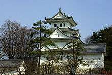
- Ōgaki Castle
- Softopia Japan
- Sumiyoshi Lighthouse
- Sunomata Castle
Notable people
- Kozō Andō , kendo teacher
- Otohiko Hara, Japanese businessman
- Hiroshi Tanahashi, professional wrestler
- Ikutaro Tokoro, patriot in the closing days of Tokugawa shogunate
- Kenkichi Yabashi , architect known for the construction and design of National Diet Building
References
- Ōgaki city official statistics (in Japanese)
- 総括 1 大垣市の沿革 (PDF). Ōgaki official website (in Japanese). Retrieved August 17, 2011.
- "Gifu / 岐阜県 (Japan): Prefecture, Cities, Towns and Villages - Population Statistics, Charts and Map". www.citypopulation.de.
- "Ogaki climate: Average Temperature, weather by month, Ogaki weather averages - Climate-Data.org". en.climate-data.org.
- "Company Outline." Ibiden. Retrieved on January 16, 2018."
- "Escolas Brasileiras Homologadas no Japão" (Archive). Embassy of Brazil in Tokyo. Retrieved on October 13, 2015.
- "フレンドリーシティ交流について". city.ogaki.lg.jp (in Japanese). Ōgaki. Retrieved 2020-04-12.
External links
| Wikimedia Commons has media related to Ōgaki, Gifu. |
- Ōgaki City official website (in Japanese)