Čelkova Lehota
Čelkova Lehota (Hungarian: Cselkószabadja) is a village and municipality in Považská Bystrica District in the Trenčín Region of north-western Slovakia.
Čelkova Lehota | |
|---|---|
Municipality | |
 | |
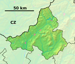 Čelkova Lehota Location of Čelkova Lehota in the Trenčín Region  Čelkova Lehota Čelkova Lehota (Slovakia) | |
| Coordinates: 49°01′N 18°32′E | |
| Country | Slovakia |
| Region | Trenčín |
| District | Považská Bystrica |
| First mentioned | 1471 |
| Area | |
| • Total | 3.705 km2 (1.431 sq mi) |
| Elevation | 445 m (1,460 ft) |
| Population | |
| • Total | 146 |
| • Density | 39/km2 (100/sq mi) |
| Postal code | 018 16 (pošta Domaniža) |
| Area code(s) | 421-42 |
| Car plate | PB |
The village lies in a beautiful natural environment near Strážovské vrchy mountain range at the end of Domaniža valley.
History
In historical records the village was first mentioned in 1471.
Geography
The municipality lies at an altitude of 445 metres and covers an area of 3.705 km². It has a population of about 146 people.
Genealogical resources
The records for genealogical research are available at the state archive "Statny Archiv in Bytca, Slovakia"
- Roman Catholic church records (births/marriages/deaths): 1670-1894 (parish B)
gollark: PDF bad. HTML good.
gollark: Have YOU voted gibson?
gollark: So if I complain about your moderation it's bad?
gollark: Also worrying. But neat?
gollark: This is neat, apparently my phone can read some data off my debit card via NFC.
External links
![]()

Panorama of village Čelkova Lehota and its environment
Municipalities of Považská Bystrica District | ||
|---|---|---|
This article is issued from Wikipedia. The text is licensed under Creative Commons - Attribution - Sharealike. Additional terms may apply for the media files.