Ísafjarðarbær
Ísafjarðarbær is a municipality of Iceland in the Westfjords region, created in 1996 from Flateyrarhreppur, Ísafjarðarkaupstaður, Mosvallahreppur, Mýrahreppur, Suðureyrarhreppur and Þingeyrarhreppur.
| Ísafjarðarbær | |
|---|---|
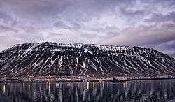 Skyline of Ísafjarðarbær | |
 Coat of arms of Ísafjarðarbær | |
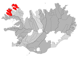 Location of Ísafjarðarbær | |
 Ísafjarðarbær | |
| Region | Westfjords |
| Constituency | Northwest Constituency |
| Mayor | Birgir Gunnarsson |
| Area | 2,379 km2 (919 sq mi) |
| Population | 3,836 (1 January 2020) |
| Density | 1.53/km2 (4.0/sq mi) |
| Municipal number | 4200 |
| Postal code(s) | 400, 401, 410, 425, 430, 470, 471 |
| Website | isafjordur |
Geography
The principal settlement is Ísafjörður, others being Hnífsdalur, Flateyri, Suðureyri and Þingeyri.
Education
- University Centre of the Westfjords — a higher education institute in Ísafjörður
- Flateyri Folk High School — a folk high school in Flateyri
- Menntaskólinn á Ísafirði — a gymnasium in Ísafjörður
Transport
The municipality is served by Ísafjörður Airport.
Twin towns – sister cities
Ísafjarðarbær is twinned with:[1]
gollark: Can you not use a μSD card?
gollark: This is not* going to be an issue later, I'm sure.
gollark: 230GB of my laptop's 512GB disk is in use, because I have many `node_modules`es, Rust projects, large games, giant toolchains (CUDA), big pretrained neural networks, a full backup of my old laptop, and several thousand memes.
gollark: I guess big Rust projects would occupy a quarter of it.
gollark: It wouldn't be that bad with a cut-down Linux distribution.
References
- "Vinabæir". isafjordur.is (in Icelandic). Ísafjarðarbær. Retrieved 2020-02-12.
This article is issued from Wikipedia. The text is licensed under Creative Commons - Attribution - Sharealike. Additional terms may apply for the media files.