West Drayton
West Drayton is a suburban town in the London Borough of Hillingdon. It was an ancient parish in the county of Middlesex and from 1929 was part of the Yiewsley and West Drayton Urban District, which became part of Greater London in 1965. The settlement is near the Colne Valley Regional Park and its centre lies 1.9 miles (3 km) north of Heathrow Airport.
| West Drayton | |
|---|---|
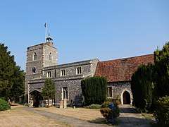 St Martin's church | |
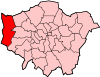
 West Drayton Location within Greater London | |
| Population | 14,370 |
| OS grid reference | TQ065795 |
| • Charing Cross | 14.8 mi (23.8 km) E |
| London borough | |
| Ceremonial county | Greater London |
| Region | |
| Country | England |
| Sovereign state | United Kingdom |
| Post town | WEST DRAYTON |
| Postcode district | UB7 |
| Dialling code | 01895 |
| Police | Metropolitan |
| Fire | London |
| Ambulance | London |
| UK Parliament | |
| London Assembly | |
Traditionally the Parish of West Drayton covers 3.4 square kilometres (1.3 sq mi). In 1901 the population of the civil parish was 984.[1] In the 2011 Census 14,370 people were living in the West Drayton electoral ward.[2][3] The ward has three councillors in the Hillingdon Borough Council.[1][4] The vast majority of the housing in West Drayton is mid-20th century.
Toponymy
In 939 the area was known as Draegtun. Tun/ton is cognate with the later form town, but originally implied any kind of farmstead of more than one family. Dray is cognate with draught (as in draft horse/a dray) implying a portage/slope used for dragging loads, or simply notable use of the dragged plough, quite possibly given about 13 other examples in England simply land under till. It is recorded as Draitone in the 1086 Domesday Book, and as Westdrayton in 1465.[5] It is thought that the West may have been added to differentiate the village from Drayton in Ealing.[6]
Geography
West Drayton lies to the south of the Great Western Main Line which run east-west with Yiewsley lying to the north of the railway line. West Drayton is northwest of junction 4 of the M4 motorway (Heathrow Airport spur), which intersects with the A408 (for Stockley Park), north for Uxbridge, and it terminates south at Heathrow Airport itself. The nearby A3044 goes through Harmondsworth to the south.
West Drayton railway station is served by TfL Rail and Great Western Railway (GWR). TfL Rail operates a stopping service between London Paddington and Reading and GWR operates a stopping service between London Paddington and Didcot Parkway.
The community has primary schools,[7] and a secondary school, Park Academy West London is on Falling Lane in Colham Green. This physically and in governance replaced Evelyns Community School.
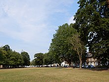
West Drayton has at its heart in the west of the parish a conservation area, The Green, along which are many buildings protected under UK law by grade II and II* listing — residential and commercial.
Local Government Elections
| Party | Candidate | Votes | % | ± | |
|---|---|---|---|---|---|
| Labour | Janet Duncan | 2,013 | |||
| Labour | Jan Sweeting | 1,923 | |||
| Labour | Stuart Mathers | 1,843 | |||
| Conservative | Cameron Bradbury | 1,749 | |||
| Conservative | Lesley Deville | 1,739 | |||
| Conservative | James Hamblin | 1,737 | |||
| BNP | Vincent Evans | 143 | |||
| Duma Polska | Sebastien Tyszlewicz | 117 | |||
| Duma Polska | Remigiusz Jaskiewicz | 95 | |||
| Majority | 94 | ||||
| Turnout | 36% | ||||
| Labour hold | Swing | ||||
| Labour hold | Swing | ||||
| Labour hold | Swing | ||||
History
The first record of West Drayton is from 939 when Æthelstan, King of the English, gave the Manor of West Drayton to the Dean and Chapter of Cathedral church of St Pauls, recorded in the Cartularium Saxonicum.[8] In the 1086 Domesday Book, West Drayton was assessed at ten hides with land suitable for six ploughs.[9] The Parish had 17 landowners which indicated a population of less than 100.[10] In 1461 a separate smaller manor, Drayton and Colham Garden Manor was first recorded, lying between Swan road and Colham Mill road.[11] Both manors shared St Martin’s Parish Church. Until 1525 West Drayton Manor was managed on behalf of the Dean and Chapter of St Paul’s by an appointment known as a Firmarius who was responsible for the day-to-day running of the estate.[10]
From 1525 St Paul’s began leasing West Drayton Manor to tenants. From 1537 the lessee of the manor was William Paget who held high office of state in the court of Henry VIII. On 1 April 1546, the Dean and Chapter of St Paul’s released the Manor of West Drayton to the Crown and two weeks later Henry granted the manor to the now knighted Sir William Paget.[10] In the same year Henry granted Paget six manors in his native Staffordshire.[12] Henry died in January 1547. Paget was made a peer of the realm as Lord Paget of Beaudesert by Edward VI in 1549.[12]
While he was leasing the manor William Paget used the existing building of St Pauls which was situated near the church. Paget described the building as his "cotage at Drayton".[10] Once owning the manor he built a new manor house, completed by 1549, which occupied the western end of the churchyard. The Manor grounds contained the Church, ornamental gardens, stables, a dovecote and other outbuildings and was enclosed by a high brick wall and two gatehouses.[11] The wall and one of the gatehouses can still be seen today. The construction of the manor house and grounds resulted in the demolition of villagers' homes on Church Road and building on the graves of generations of West Drayton people in the churchyard. In addition to this, Paget enclosed 150 acres of common land to add to his demesne. In 1550 Paget legalised his position by obtaining a royal pardon for his actions.[10] The loss of the Parish churchyard was compensated for by the granting of an alternative burial site which was near to where Drayton Hall is today. The burial site was used until 1888.[10]
After serving as Lord Privy Seal under Mary I, poor health meant William Paget played little part in public life after the accession of Queen Elizabeth I in 1558, although as a Privy Councillor his advice was often sought.[12] He died in West Drayton on 9 June 1563.[12] He was succeeded by his son Henry, who died five years later without male Issue. Henry’s brother Thomas became the 3rd Baron Paget in 1568.
Thomas Paget (1544-1590) and his brother Charles were both devout Roman Catholics, and would not conform to the Protestant religion of Queen Elizabeth I. With the uncovering of the Throckmorton Plot in November 1583, Paget fled to Paris, joining his brother Charles who had been in exile there since 1581. The failed plot's objective had been for English Catholics to depose Elizabeth and place Catholic Mary, Queen of Scots on the throne after a Spanish-backed invasion by French forces under Henry, Duke of Guise. Elizabeth issued a proclamation commanding Thomas Paget to return to England and in June 1584 a formal demand for the surrender of Paget was made to the King of France by the English ambassador, which was not carried out. In 1587 he was attainted of treason by act of parliament. Paget received a pension of 180 crowns per month from Philip II of Spain and died in Brussels in early 1590.[13]
In 1587, with Thomas Paget being attainted, his lands including West Drayton were confiscated by the Crown.[11] Elizabeth granted the manor to her Lord Chancellor, Sir Christopher Hatton. Hatton died in 1591 and from 1592 the manor was leased to George Carey. Carey became 2nd Baron Hunsdon in 1596 and entertained Elizabeth at the West Drayton Manor House in October 1602.[10]
The former RAF West Drayton hosted a military air traffic control centre co-located with the civil London Terminal Control Centre, residual functions of which were relocated to Swanwick, Hampshire entirely by January 2008. The site was redeveloped for housing.
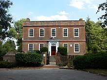
St Martin's Church
West Drayton's parish church, dedicated to Martin of Tours, was first mentioned in the 12th century. However, no trace of the original church remains. The present church was first built in the 13th century, of which the base of the tower, the piscina and the north chancel wall are incorporated in the present building, which dates from the 15th century. The church was heavily restored and reordered in 1974, when the altar was resited at the west end. The baptismal font is a splendid example of mid-15th century work, and the parish chest is early 17th century. There are monumental brasses to Richard Roose (1406), Margaret Burnell (1529), her son John Burnell (1551) and Dr James Good (1581, a physician to Mary, Queen of Scots). There is a small memorial tablet to Henry Carey, 1st Baron Hunsdon, Lord of the Manor, and a cousin of Queen Elizabeth I.[14]
Local economy
Historically, employment was commonly connected to agriculture, the railway yards and the canal. In the modern day, West Drayton has a mixture of tradespeople, airport workers, construction workers and commuters in office professions or public utilities such as schools and hospitals. Its housing hosts people with a range of incomes, with relatively large areas built aesthetically in keeping with existing housing by the local authority.
West Drayton has rapid connectivity to the M4 and thereafter to the M25 and motorways north-west and south-west. The M4 spur and the A408 Stockley Road by-pass links to Heathrow Airport and to the Stockley Business Park, respectively. The Stockley Close Industrial estate lies on the eastern side of the by-pass. The businesses situated here are: Ocado, Greencore, Carrier Retail Systems, Amalga Ltd, Clevertronics, MNX Global Logistics and the Heathrow Parcel Centre. The Industrial Estate was the former home of the British Midland International Training Centre.[15][16][17]
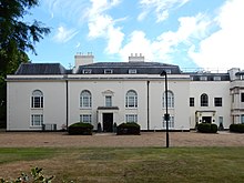
Drayton Hall has the offices of Ferring Pharmaceuticals, Kore Wireless and North South Wines. Britannia Court, on the east side of The Green, has the offices of the Schools HR Co-operative, MagLabs, Wells Burcombe LLP, MD Developments Ltd, Insultec Ltd, QIK Group and Flight Data Systems.
Many hotels are situated in neighbouring Harmondsworth and Longford. Notably Guoman Hotel Management (UK) Limited has its head office in the Thistle London Heathrow Terminal 5 in Longford.[18][19] Waterside, the head office of British Airways, is in Harmondsworth.[20]
Culture and Recreation
- The Yiewsley and West Drayton Arts Council maintain the Southlands Arts Centre. They oversee events and promote local creativity. There are many exhibitions, music festivals, and creative endeavours from fine arts, photography, film-making and music groups.
- Community events are held at the Yiewsley and West Drayton Community centre on Harmondsworth Road.
- West Drayton Library is situated on Station Road.
- The Yiewsley and West Drayton Band is a second section brass band established in 1890 and maintains a year round programme of concerts and community events.
- 1381 Squadron (West Drayton & Yiewsley) Royal Air Force Air Cadets are based at Rutters Close.
- The 2nd West Drayton Scout Group are based at Rowan Road.
- A community radio station, 91.8 Hayes FM, serves the Hillingdon Borough area.[21]
- Two local amateur football teams train and compete: Drayton Explorers, at Sipson Recreation Ground, Sipson Way and Draytonians FC.
- Three types of gyms and exercise facilities are in West Drayton:
- The Closes; local authority — grass field, outdoor gym and ball courts such as for tennis
- Boxercise gym/club and two ladies-only exercise studios
- Novotel swim instructor sessions and gym passes
- The council's nearest leisure centre in south Hayes to the east, at Botwell Green, and closer William Byrd indoor pool in Harlington.
- Nuffield Health club is at Stockley Park between Yiewsley and south Hayes has many facilities including pool, spinning (indoor cycling) clubs and instructors.
- The Colne Valley regional park lies on the western side of West Drayton.
Demography
As of the 2011 census, 57% of the population was White British.[22] Living in the ward were 14,370 people according to the 2011 Census.[2]
The decennial censuses between 1801 and 1901 each show a rise in population and a low population density. From 1801 when the population of the almost identically sized ecclesiastical parish (civil parishes were invented later in the 19th century) was 515; to 1901 when the population of the civil parish was 984.[1]
Notable people
- William Paget, 1st Baron Paget KG PC (1506-1563), statesman, holder of high office in the courts of Henry VIII, Edward VI, Mary I and Elizabeth I. Lived in West Drayton from 1537 until his death in 1563.
- William Paget, 4th Baron Paget (1572-1629), adventurer of the London Company, is buried in West Drayton.
- Publisher Sir Allen Lane founder of Penguin Books, lived at The Mill House.[23]
- Sir Charles Aubrey Smith Captain of the England Cricket team and Hollywood actor, lived in West Drayton between 1903 and 1930.[23]
- William Nigel Bruce Hollywood actor, lived at 1 De Burgh Cresent between 1905 and 1934.[23]
- Henry Hevelock Ellis physician and writer, lived at Woodpecker Farm, Mill Road between 1911 and 1913.[23]
- Cosmo Hamilton Playwright and Novelist, lived at Southlands.[24]
- J.W. (Jack) Hearne, Cricketer, who represented England in twenty-four Test matches, lived in Bagley Close.[23]
- Ronnie Wood, guitarist in rock bands The Rolling Stones and Faces, was born in West Drayton.
- Blues singer Art Wood (1937-2006), brother of Ronnie, was born in West Drayton.
- Actor Julian Rhind-Tutt was born in West Drayton.[23]
References
- 838 acres. 'Table of population, 1801-1901', in A History of the County of Middlesex: Volume 2, General ed. William Page (London, 1911), pp. 112-120. British History Online http://www.british-history.ac.uk/vch/middx/vol2/pp112-120 [accessed 25 May 2018].
- "Usual resident population". NOMIS. Office for National Statistics. 2011. Retrieved 6 May 2013.
- "Archived copy". Archived from the original on 22 February 2014. Retrieved 9 June 2014.CS1 maint: archived copy as title (link)
- https://www.hillingdon.gov.uk/article/7629/Facts-and-statistics-about-the-London-Borough-of-Hillingdon
- Mills, A. D.: A Dictionary of British Place-Names (Oxford University Press, 2003)
- "Survey of English Place-Names". epns.nottingham.ac.uk. Retrieved 15 August 2020.
- West Drayton primary school
- de Gray Birch, Walter. "737". Cartularium Saxonicum Vol 2 AD 840-947. p. 451. ISBN 9781108045087.
- Hopkins, Heather (April 2009). "An Archaeological Desk-Based Assessment for Inland Homes" (PDF). London Borough of Hillingdon. Retrieved 30 May 2011.
- Cox, A.H. (1983). West Drayton & Yiewsley through the centuries. Hillingdon Borough Libraries. ISBN 0907869033.
- "A history of the County of Middlesex Volume 3 West Drayton: Manors". www.british-history.ac.uk. British History Online. pp. 191–195. Retrieved 15 August 2020.
- Hawkyard, A. D.K. "PAGET, William [by 1506-63]". www.historyofparliamentonline.org. Retrieved 17 August 2020.
- Thompson Cooper. "Thomas Paget, 3rd Baron Paget". gentrekker.com. Oxford Dictionary of National Biography. pp. 43, 59–60. Retrieved 17 August 2020.
- Weinreb, Ben; Hibbert, Christopher (1992). The London Encyclopaedia (reprint ed.). Macmillan. p. 754.
- "bmi’s company rewards." British Midland International. Retrieved on 28 December 2011. "Stockley Close, West Drayton, Middlesex, UB7 9BL"
- "British Midland Airways Limited Stockley Close, West Drayton Near Heathrow, London." KingSturge. Retrieved on 28 December 2011.
- "the nineties Archived 10 June 2012 at the Wayback Machine." British Midland International. Retrieved on 28 December 2011.
- "Corporate Office." Thistle Hotels. Retrieved on 28 December 2011. "The corporate office is based at Thistle London Heathrow and is situated across opposite the main reception adjacent to the Conference Centre"
- "Thistle London Heathrow." Thistle Hotels. Retrieved on 28 December 2011. "Bath Road, Longford West Drayton UB7 0EQ"
- "Benefits and features." British Airways. Retrieved on 14 February 2011. "The promoters are British Airways Plc, Waterside, PO Box 365, Harmondsworth, West Drayton, UB7 0GA."
- Ofcom-licences webpages, UK Government, accessed 2018-05-01
- Services, Good Stuff IT. "West Drayton - UK Census Data 2011". UK Census Data. Retrieved 10 April 2018.
- Skinner, James (2003). West Drayton and Yiewsley. The History Press. ISBN 9780752428413.
- "Southlands history". www.southlandsarts.co.uk. Retrieved 17 August 2020.
External links
| Wikimedia Commons has media related to West Drayton. |
- UB7 local website
- Southlands Arts Centre website
- British History - West Drayton
- Uxbridge & Hillingdon Times - local newspaper
- Yiewsley and West Drayton Band
- Library
- Diners Lounge