Grade I and II* listed buildings in the London Borough of Hillingdon
There are over 9,000 Grade I listed buildings and 20,000 Grade II* listed buildings in England. This page is a list of these buildings in the London Borough of Hillingdon.
Grade I
| Name | Location | Type | Completed [note 1] | Date designated | Grid ref.[note 2] Geo-coordinates |
Entry number [note 3] | Image |
|---|---|---|---|---|---|---|---|
| Breakspear House | Harefield, Hillingdon | House | Early-mid 17th century | 8 May 1950 | TQ0607989641 51°35′44″N 0°28′12″W |
1080262 | 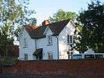 Breakspear House |
| Church of St Martin of Tours | Ruislip, Hillingdon | Parish Church | Mid 13th century | 24 January 1950 | TQ0915387604 51°34′36″N 0°25′34″W |
1285697 | |
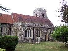
| Church of St Mary | Harefield, Hillingdon | Parish Church | 12th century | 8 May 1950 | TQ0533389586 51°35′43″N 0°28′51″W |
1358363 | 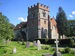 Church of St Mary |
| Church of St Peter and St Paul | Harlington, Hillingdon | Parish Church | 12th century | 27 May 1949 | TQ0880078214 51°29′33″N 0°26′03″W |
1080163 | 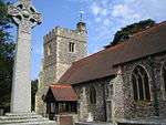 Church of St Peter and St Paul |
| Group Operations Room | RAF Uxbridge, Hillingdon | Underground Military Headquarters | 1938–1939 | 1 December 2005 | TQ0654883514 51°32′26″N 0°27′54″W |
1392556 |  Group Operations Room |
| Ickenham Manor | Ickenham, Hillingdon | Hall House | LATE MEDIEVAL | 8 May 1950 | TQ0829385329 51°33′23″N 0°26′22″W |
1080187 |  |
| Manor Farm Barn (to West of Church of St Mary) | Harmondsworth, Hillingdon | Tithe Barn | LATE MEDIEVAL | 1 March 1950 | TQ0563277848 51°29′23″N 0°28′48″W |
1194332 | 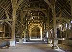 Manor Farm Barn (to West of Church of St Mary) |
| Outbuildings to North of Swakeleys | Ickenham, Hillingdon | Courtyard | 6 September 1974 | TQ0742885753 51°33′38″N 0°27′06″W |
1286571 | 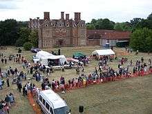 Outbuildings to North of Swakeleys | |
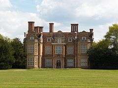
| Swakeleys | Ickenham, Hillingdon | House | 1629–1638 | 1 May 1956 | TQ0742185706 51°33′36″N 0°27′06″W |
1080295 |
Grade II*
| Name | Location | Type | Completed [note 1] | Date designated | Grid ref.[note 2] Geo-coordinates |
Entry number [note 3] | Image |
|---|---|---|---|---|---|---|---|
| Almshouses | Harefield, Hillingdon | Almshouse | 16th century | 8 May 1950 | TQ0515689824 51°35′51″N 0°29′00″W |
1358364 | 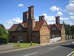 Almshouses |
| Cedars House | Hillingdon, Hillingdon | House | c. 1580 | 8 May 1950 | TQ0694883003 51°32′09″N 0°27′34″W |
1284903 | |
| Church of St Dunstan | Cranford, Hillingdon | Church | 13th century | 27 May 1949 | TQ1016078179 51°29′31″N 0°24′53″W |
1181190 |  Church of St Dunstan |
| Church of St Giles | Ickenham, Hillingdon | Parish Church | Late 14th century | 8 May 1950 | TQ0795086264 51°33′54″N 0°26′38″W |
1080229 | |
| Church of St John | Hillingdon, Hillingdon | Parish Church | 13th century | 8 May 1950 | TQ0691482916 51°32′06″N 0°27′36″W |
1080160 | 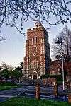 Church of St John |
| Church of St Laurence | Cowley, Hillingdon | Parish Church | 12th century | 8 May 1950 | TQ0599482043 51°31′38″N 0°28′24″W |
1286371 | 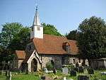 Church of St Laurence |
| Church of St Margaret | Uxbridge | 14th-15th century | 1985–88 | 8 May 1950 | TQ0552584099 51°32′45″N 0°28′47″W |
1180516 | 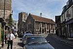 Church of St Margaret |
| Church of St Martin | West Drayton, Hillingdon | Parish Church | 13th century | 1 March 1950 | TQ0616379542 51°30′17″N 0°28′18″W |
1358325 | 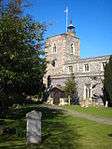 Church of St Martin |
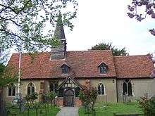
| Church of St Mary | Hayes, Hillingdon | Parish Church | 13th century | 27 May 1949 | TQ0970881077 51°31′05″N 0°25′13″W |
1080233 | 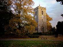 Church of St Mary |
| Church of St Mary, Harmondsworth | Harmondsworth, Hillingdon | Parish Church | 12th century | 1 March 1950 | TQ0569577808 51°29′22″N 0°28′45″W |
1080201 |  Church of St Mary, Harmondsworth |
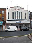
| Regal Cinema, Uxbridge | Hillingdon | Cinema | 1930–31 | 15 November 1976 | TQ0589583954 51°32′40″N 0°28′28″W |
1080111 | |
| Dovecote to North West of Breakspear House | Harefield, Hillingdon | Dovecote | 17th century | 4 July 1968 | TQ0601689692 51°35′46″N 0°28′15″W |
1080263 | |
| Footbridge Across River Colne, to North of Denham Court | Denham Court, Hillingdon | Footbridge | c. 1850 | 30 June 1986 | TQ0515587329 51°34′30″N 0°29′02″W |
1065962 | |
| Fray's Cottage Old Mill House | West Drayton, Hillingdon | House | Late 18th century | 1 March 1950 | TQ0542979082 51°30′03″N 0°28′57″W |
1181607 | 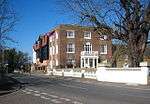 Fray's Cottage Old Mill House |
| Great Barn to West of Manor Farm Yard | Ruislip | Barn | Late 17th century or 18th century | 6 September 1974 | TQ0897787755 51°34′41″N 0°25′43″W |
1358359 | 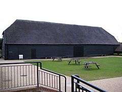 Great Barn to West of Manor Farm Yard |
| Green End | Northwood, Hillingdon | House | 17th century | 14 September 1993 | TQ0895391704 51°36′49″N 0°25′40″W |
1065964 | |
| Harefield Park | Harefield, Hillingdon | House | EARLY-MID 18th century | 6 September 1974 | TQ0493390841 51°36′24″N 0°29′10″W |
1080177 | .jpg) Harefield Park |
| Heinz Administrative Headquarters and Former Research Laboratories | Hayes, Hillingdon | Commercial Office | Mid 20th century | 24 November 1995 | TQ0887582471 51°31′50″N 0°25′55″W |
1242724 |  Heinz Administrative Headquarters and Former Research Laboratories |
| Hillingdon Court | Hillingdon, Hillingdon | Country House | 1854-8 | 16 August 1983 | TQ0684883829 51°32′36″N 0°27′38″W |
1080114 | |
| Mount Vernon Hospital Chapel | Northwood | Chapel | 1904 | 6 September 1974 | TQ0785991779 51°36′52″N 0°26′37″W |
1358386 | |
| No. 9-15 High Street | Ruislip | Continuous Jetty House | 16th century | 24 January 1950 | TQ0912487593 51°34′36″N 0°25′36″W |
1080204 | 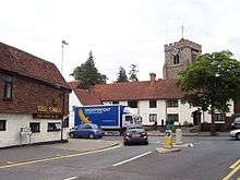 No. 9-15 High Street |
| Southlands | West Drayton, Hillingdon | House | Early 18th century | 1 March 1950 | TQ0588779170 51°30′06″N 0°28′33″W |
1286038 | |
| The Crown and Treaty Inn | Uxbridge | Inn | 1576 | 8 May 1950 | TQ0519884529 51°32′59″N 0°29′03″W |
1080148 | .jpg) The Crown and Treaty Inn |
| The Frays | West Drayton, Hillingdon | House | Late 16th century | 6 September 1974 | TQ0554679319 51°30′11″N 0°28′51″W |
1358349 | |
| The Market House | Uxbridge | Market House | 1788 | 8 May 1950 | TQ0553784107 51°32′46″N 0°28′46″W |
1080208 | 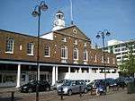 The Market House |
| The Old Gatehouse | West Drayton, Hillingdon | Manor House | Early 16th century | 1 March 1950 | TQ0617179491 51°30′16″N 0°28′18″W |
1193001 | 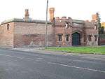 The Old Gatehouse |
| Wall Running South from the Old Gatehouse and West Along Front of Gatehouse Nurseries | West Drayton, Hillingdon | Wall | Early 16th century | 6 September 1974 | TQ0615579469 51°30′15″N 0°28′19″W |
1358326 | Wall Running South from the Old Gatehouse and West Along Front of Gatehouse Nurseries |
| Walls Around St Martin's Churchyard | West Drayton, Hillingdon | Wall | 16th century | 6 September 1974 | TQ0618579549 51°30′18″N 0°28′17″W |
1286366 | |
| Walls to East and South of Garden of Number 28 (coombe House) | West Drayton, Hillingdon | Wall | Early 16th century | 6 September 1974 | TQ0609579466 51°30′15″N 0°28′22″W |
1193014 | |
Notes
- The date given is the date used by Historic England as significant for the initial building or that of an important part in the structure's description.
- Sometimes known as OSGB36, the grid reference is based on the British national grid reference system used by the Ordnance Survey.
- The "List Entry Number" is a unique number assigned to each listed building and scheduled monument by Historic England.
External links

This article is issued from Wikipedia. The text is licensed under Creative Commons - Attribution - Sharealike. Additional terms may apply for the media files.