Warrenheip, Victoria
Warrenheip /wɒrənˈhiːp/ is a suburb of Ballarat, Victoria, Australia on the eastern rural-urban fringe named after nearby Mount Warrenheip. At the 2016 census, Warrenheip had a population of 669.[1]
| Warrenheip Ballarat, Victoria | |||||||||||||||
|---|---|---|---|---|---|---|---|---|---|---|---|---|---|---|---|
 Warrenheip | |||||||||||||||
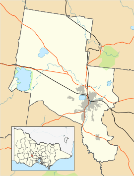
| Coordinates | 37.575°S 143.923°E | ||||||||||||||
| Population | 669 (2016 census)[1] | ||||||||||||||
| Postcode(s) | 3352 | ||||||||||||||
| Location | |||||||||||||||
| LGA(s) | |||||||||||||||
| State electorate(s) | Buninyong | ||||||||||||||
| Federal Division(s) | Ballarat | ||||||||||||||
| |||||||||||||||
While Ballarat district gold prospectors were present in the 1860s and a primary school was opened[2] however it was not until the 1870s that Warrenheip was established as a separate agricultural community. The railway from Geelong to Ballarat was built nearby and Warrenheip railway station opened in 1873. As Ballarat expanded eastward during the 1980s, the junction of the Western Highway became a location for light industry. Today the industry dominates Warrenheip and continues to expand with the development of business parks. Residential Warrenheip consists mainly of large semi-rural blocks.
References
- Australian Bureau of Statistics (27 June 2017). "Warrenheip (State Suburb)". 2016 Census QuickStats. Retrieved 7 July 2017.

- http://whps.vic.edu.au/about.html