Volnovakha Raion
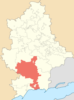
Volnovakha Raion (Ukrainian: Волноваський район, Volnovas’kyi raion) is one of the 18 administrative raions (a district) of Donetsk Oblast, located in southwestern Ukraine. The administrative center of the district is located in the city of Volnovakha. Population: 83,930 (2013 est.)[4]
Volnovas'kyi Raion Волноваський район | |
|---|---|
Raion | |
 Flag  Coat of arms | |
 | |
| Coordinates: 48°00′N 34°49′E | |
| Country | |
| Region | |
| Established | 1923 |
| Admin. center | Volnovakha[1][2] |
| Subdivisions | List
|
| Government | |
| • Governor | Volodymyr Nesterenko[3] |
| Area | |
| • Total | 2,549.44 km2 (984.34 sq mi) |
| Population (2013) | |
| • Total | |
| Time zone | UTC+02:00 (EET) |
| • Summer (DST) | UTC+03:00 (EEST) |
| Postal index | 85700-84791 |
| Area code | +380 6244 |
| Website | www |
History
On 9 December 2014, the Verkhovna Rada, Ukraine's national parliament, changed the boundaries and total area of the Volnovakha Raion to encompass 2,549.44 km2 (984.34 sq mi) following the events surrounding the War in Donbass.[1]
Subsequently, the Governor of Donetsk Oblast Oleksandr Kikhtenko adopted a resolution moving the administrative center of the Novoazovsk Raion to the urban-type settlement of Vynohradne; the administrative center of the Telmanove Raion to the urban-type settlement of Myrne; and the administrative center of the Yasynuvata Raion to the urban-type settlement of Ocheretyne.[2]
Demographics
According to the 2001 Ukrainian Census,[5]
| Ethnicity | Number | Proportion |
| Ukrainians | 72,346 | 78.2% |
| Russians | 15,128 | 16.4% |
| Greeks | 2,959 | 3.2% |
| Belarusians | 494 | 0.5% |
| Armenians | 260 | 0.3% |
| Moldovans | 248 | 0.3% |
References
- Laws of Ukraine. Verkhovna Rada of Ukraine No. 32-VIII: Про зміни в адміністративно-територіальному устрої Донецької області, зміну і встановлення меж Волноваського, Новоазовського та Тельманівського районів Донецької області (On the changes in the administrative and territorial structure of Donetsk Oblast, changing and defining the boundaries of the Volnovakha, Novoazovsk and Telmanove Raions of Donetsk Oblast). Adopted on 11 December 2014. (Ukrainian)
- "In the Donetsk Oblast three district centers removed from the territory seized by militants". Ukrayinska Pravda (in Ukrainian). 8 December 2014. Retrieved 31 December 2014.
- "Chairman of the Raion State Administration". Official web-site (in Ukrainian). Volnovakha RDA. Retrieved 1 January 2015.
- Чисельність наявного населення України [Actual population of Ukraine] (in Ukrainian). State Statistics Service of Ukraine. Retrieved 21 January 2015.
- "Національний склад та рідна мова населення Донецької області" [Ethnic and linguistic composition of Donetsk Oblast] (in Ukrainian). Archived from the original on 27 November 2012.
External links
- "Main". Official web-site (in Ukrainian). Volnovakha RDA. Retrieved 1 January 2015.
| Raions | |||||
|---|---|---|---|---|---|
| Hromadas | |||||
| Cities |
| ||||
| |||||