Amvrosiivka Raion
The Amvrosiivka Raion (Ukrainian: Амвросіївський район, translit.: Amvrosiivs'kyi raion; Russian: Амвросиевский район, translit.: Amvrosievskiy raion) is a raion (district) within the eastern part of Donetsk Oblast in the Eastern Ukraine. The administrative center of the raion is the town of Amvrosiivka. Its population is approximately 44,379 (2017 est.)[1].
Amvrosiivs'kyi Raion Амвросіївський район | |
|---|---|
Raion | |
 Flag  Coat of arms | |
 | |
| Coordinates: 47°49′12″N 38°28′12″E | |
| Country | |
| Region | Donetsk Oblast |
| Established | N/A |
| Admin. center | Amvrosiivka |
| Subdivisions | List
|
| Area | |
| • Total | 1,455 km2 (562 sq mi) |
| Population | |
| • Total | 44,379 |
| • Density | 31/km2 (79/sq mi) |
| Time zone | UTC+02:00 (EET) |
| • Summer (DST) | UTC+03:00 (EEST) |
| Postal index | 873-XX |
| Area code | 380 |
| Website | Verkhovna Rada website |
Geography
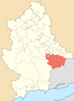
The raion has an international border with the Russian Federation (Rostov Oblast) to its east and south (still not established), Starobesheve Raion to its southwest, cities of Donetsk and Makiivka to the west, and Shakhtarsk Raion to its north. The border with Russia stretches here for 73 kilometres (45 mi). The raion was established on 7 March 1923 as a part of Taganrog Uyezd (county), Donetsk Governorate initially, a month later it was included into the Stalino Okruha (Yuzivka, at first). Eventually the raion became a part of the Donetsk Oblast.
The raion is located in the southern portion of the Donetsk Ridge and its territory belongs to a steppe zone of Ukraine. On the territory of the raion are located following natural landmarks:
- Gultch Horka - here can be found eremurus of the Ice Age
- Regional landscape park "Donetsk Ridge"
- Berdyanka tract, a part of the Berdyansk State Reserve
- Pristenske tract, a local reserve
- Gultch Kazenna, an archaeological landmark of Paleolithic period
Within the Amvrosiivka Raion there is: one city (Amvrosiivka), 3 urban-type settlements (Kuteynykove, Novoamvrosiivs'ke, and Voykovskyi), 30 selsoviets, and 43 settlements. Also included within the raion are: 14 industrial organizations, 4 construction and transport organizations, 12 kolhozy, 11 sovhozy, 2 pizza companies, 10 hospitals, 35 schools, 24 clubs, 38 libraries and music schools.
An architectural monument in the raion is the Ioanno-Bohoslovska Church (1905-selo Vasyl'evka). Before 1917 the raion was part of the Don Host Oblast in the Russian Empire.
Settlements
- Voikovs'kyi (Ukrainian: Войковський; formerly: since the 19th century-1940 Kapany) is an urban-type settlements (townlet) with a population of 1,476. A brick factory by the name of Voikova lies within the city, formerly known as Metallist, as well as 2 libraries.
- Kuteinykove (Ukrainian: Кутейникове; since 1878) is an urban-type settlement (townlet) with a population of 2,156. The town comprises the Bondaryevskoe, Zaliznichnoe, Zerkalnoe, Klenovka, Merzhki, Metallist, Petrenki, Pobeda and Svobodnoe settlements.
- Novoamvrosiivs'ke (Ukrainian: Новоамвросіївське; since the 19th century) is an urban-type settlements (townlet) with a population of 2,582. A hospital, and 2 libraries are located within the city.
- Blahodatne (Ukrainian: Благодатне; in 1801-1926 Amvrosiivka) is a selo (village) with a population of 3,648. Blahodatne is a former kolhoz, Kalinina. A hospital, and 2 libraries are located within the city. The city comprises the Velikoe Mishkove, Zhukova Balka, Kotovskogo, Mala Shishovka, Novoklinovka, Novopetrovka, Podniki, Svistuny and Seyatel' settlements.
Demographics
As of the Ukrainian Census of 2001:[2]
- Ethnicity
- Ukrainians: 71.0%
- Russians: 26.2%
- Belarusians: 0.6%
- Armenians: 0.5%
- Language
References
- "Чисельність наявного населення України (Actual population of Ukraine)" (in Ukrainian). State Statistics Service of Ukraine. Retrieved 26 August 2017.
External links
- (in Ukrainian) Verkhovna Rada website - Administrative divisions of the Amvrosiivka Raion
| Raions | |||||
|---|---|---|---|---|---|
| Hromadas | |||||
| Cities |
| ||||
| |||||