Telmanove Raion
Telmanove Raion (Ukrainian: Тельманівський район, Telmanivskyi raion) is one of the 18 administrative raions (a district) of Donetsk Oblast, located in southeastern Ukraine. The administrative center of the district is located in the urban-type settlement of Boykivske, previously Telmanove. Population: 29,550 (2013 est.)[3] The raion was named after the German Communist leader Ernst Thälmann.
Telmanove Raion Тельманівський район | |
|---|---|
Raion | |
 Flag  Coat of arms | |
 | |
| Country | |
| Region | Donetsk Oblast |
| Established | 1923 |
| Admin. center | Telmanove (de jure) Myrne (de facto)[1][2] |
| Subdivisions | List
|
| Government | |
| • Governor | Olga Afenkina |
| Area | |
| • Total | 812.92 km2 (313.87 sq mi) |
| Population (2013) | |
| • Total | |
| Time zone | UTC+02:00 (EET) |
| • Summer (DST) | UTC+03:00 (EEST) |
| Postal index | 87100-87182 |
| Area code | +380 6279 |
History
As the result of the 1951 Polish–Soviet territorial exchange, the Soviet authorities deported and resettled approximately 400 families of Boykos from village of Chorna (today Czarna in Poland), the former Nyzhni Ustryky Raion of Drohobych Oblast that was transferred to Poland.
On 9 December 2014, the Verkhovna Rada, Ukraine's national parliament, changed the boundaries and total area of the Telmanove Raion to encompass 812.92 km2 (313.87 sq mi). The district's administration buildings and government was moved to the Myrne urban-type settlement following the events surrounding the War in Donbass.[1][2]
A small part of the raion on the west bank of the Kalmius River is under Ukrainian army control, from the north city of Starohnativka to the south city of Mykolaivka.
In 2016, Ukraine's national parliament, the Verkhovna Rada, renamed Telmanove Raion into Boykivske Raion, in memory of the Boykos people, who were deported from Czarna, Bieszczady County (today in Poland) after the 1951 Polish–Soviet territorial exchange.
Geography
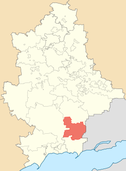
Telmanove Raion borders Novoazovsk Raion to its south, Nikolske Raion to its southwest, Volnovakha Raion to its west, Starobesheve Raion to its north. From the east, the raion is bounded by the international Russia-Ukraine border.
Administrative divisions
The district is divided into three settlement councils and twelve rural councils.
Demographics
According to the 2001 Ukrainian Census:[4]
| Ethnicity | ||
| Ukrainians | 20,442 | 57.8% |
| Russians | 7,359 | 20.8% |
| Greeks (Urums) | 6,172 | 17.5% |
| Tatars | 623 | 1.8% |
| Belarusians | 165 | 0.5% |
| Germans | 152 | 0.4% |
Note: Urums are Turkic speaking Greeks. Many of them were deported here with the First annexation of Crimea by the Russian Empire (1784) from Balaklava, on the Crimean Peninsula, once a cultural center for Pontic Greeks (see also Mariupol Greek).
Gallery
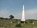 Monument in Konkove (25th Anniversary of Donbas liberation from Nazi invaders)
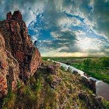 Landscape of the Kalmius Reserve
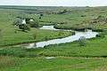 Kalmius River at the Kalmius Reserve
References
- Laws of Ukraine. Verkhovna Rada of Ukraine No. 32-VIII: Про зміни в адміністративно-територіальному устрої Донецької області, зміну і встановлення меж Волноваського, Новоазовського та Тельманівського районів Донецької області (On the changes in the administrative and territorial structure of Donetsk Oblast, changing and defining the boundaries of the Volnovakha, Novoazovsk and Telmanove Raions of Donetsk Oblast). Adopted on 11 December 2014. (Ukrainian)
- "In the Donetsk Oblast three district centers removed from the territory seized by militants". Ukrayinska Pravda (in Ukrainian). 8 December 2014. Retrieved 31 December 2014.
- Чисельність наявного населення України [Actual population of Ukraine] (in Ukrainian). State Statistics Service of Ukraine. Retrieved 21 January 2015.
- "Національний склад та рідна мова населення Донецької області" [Ethnic and linguistic composition of Donetsk Oblast] (in Ukrainian). Archived from the original on 27 November 2012.
| Raions | |||||
|---|---|---|---|---|---|
| Hromadas | |||||
| Cities |
| ||||
| |||||