Verteuil-sur-Charente
Verteuil-sur-Charente is a commune in the Charente department in southwestern France.
Verteuil-sur-Charente | |
|---|---|
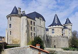 Château de Verteuil | |
Location of Verteuil-sur-Charente 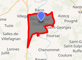
| |
 Verteuil-sur-Charente  Verteuil-sur-Charente | |
| Coordinates: 45°58′59″N 0°13′50″E | |
| Country | France |
| Region | Nouvelle-Aquitaine |
| Department | Charente |
| Arrondissement | Confolens |
| Canton | Charente-Nord |
| Intercommunality | Trois Vallées |
| Government | |
| • Mayor (2014–2020) | Clauddy Seguinar |
| Area 1 | 14.24 km2 (5.50 sq mi) |
| Population (2017-01-01)[1] | 658 |
| • Density | 46/km2 (120/sq mi) |
| Time zone | UTC+01:00 (CET) |
| • Summer (DST) | UTC+02:00 (CEST) |
| INSEE/Postal code | 16400 /16510 |
| Elevation | 72–133 m (236–436 ft) |
| 1 French Land Register data, which excludes lakes, ponds, glaciers > 1 km2 (0.386 sq mi or 247 acres) and river estuaries. | |
The village is dominated by the Château de Verteuil.[2]
Population
| Year | Pop. | ±% |
|---|---|---|
| 1793 | 1,110 | — |
| 1800 | 1,287 | +15.9% |
| 1806 | 1,311 | +1.9% |
| 1821 | 1,238 | −5.6% |
| 1831 | 1,336 | +7.9% |
| 1841 | 1,347 | +0.8% |
| 1846 | 1,339 | −0.6% |
| 1851 | 1,318 | −1.6% |
| 1856 | 1,277 | −3.1% |
| 1861 | 1,250 | −2.1% |
| 1866 | 1,193 | −4.6% |
| 1872 | 1,148 | −3.8% |
| 1876 | 1,104 | −3.8% |
| 1881 | 1,068 | −3.3% |
| 1886 | 1,094 | +2.4% |
| 1891 | 1,041 | −4.8% |
| 1896 | 965 | −7.3% |
| 1901 | 888 | −8.0% |
| 1906 | 895 | +0.8% |
| 1911 | 950 | +6.1% |
| 1921 | 794 | −16.4% |
| 1926 | 744 | −6.3% |
| 1931 | 742 | −0.3% |
| 1936 | 749 | +0.9% |
| 1946 | 800 | +6.8% |
| 1954 | 782 | −2.2% |
| 1962 | 803 | +2.7% |
| 1968 | 802 | −0.1% |
| 1975 | 719 | −10.3% |
| 1982 | 770 | +7.1% |
| 1990 | 714 | −7.3% |
| 1999 | 719 | +0.7% |
| 2005 | 715 | −0.6% |
| 2010 | 609 | −14.8% |
| 2015 | 643 | +5.6% |
| 2017 | 658 | +2.3% |
See also
References
- "Populations légales 2017". INSEE. Retrieved 6 January 2020.
- "Le Cadre". Réception parc château de Verteuil. Retrieved 2015-03-29.
External links

| Authority control |
|
|---|
This article is issued from Wikipedia. The text is licensed under Creative Commons - Attribution - Sharealike. Additional terms may apply for the media files.