Écuras
Écuras is a commune in the Charente department in southwestern France.
Écuras | |
|---|---|
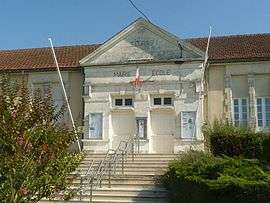 Town hall | |
Location of Écuras 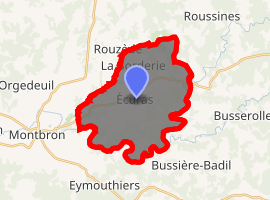
| |
 Écuras  Écuras | |
| Coordinates: 45°41′04″N 0°34′05″E | |
| Country | France |
| Region | Nouvelle-Aquitaine |
| Department | Charente |
| Arrondissement | Angoulême |
| Canton | Val de Tardoire |
| Intercommunality | Seuil Charente-Périgord |
| Government | |
| • Mayor (2008–2014) | Claude Fils |
| Area 1 | 24.22 km2 (9.35 sq mi) |
| Population (2017-01-01)[1] | 582 |
| • Density | 24/km2 (62/sq mi) |
| Time zone | UTC+01:00 (CET) |
| • Summer (DST) | UTC+02:00 (CEST) |
| INSEE/Postal code | 16124 /16220 |
| Elevation | 111–280 m (364–919 ft) (avg. 218 m or 715 ft) |
| 1 French Land Register data, which excludes lakes, ponds, glaciers > 1 km2 (0.386 sq mi or 247 acres) and river estuaries. | |
Population
| Year | Pop. | ±% |
|---|---|---|
| 1793 | 1,400 | — |
| 1800 | 1,499 | +7.1% |
| 1806 | 1,547 | +3.2% |
| 1821 | 1,613 | +4.3% |
| 1831 | 1,650 | +2.3% |
| 1841 | 1,677 | +1.6% |
| 1846 | 1,788 | +6.6% |
| 1851 | 1,772 | −0.9% |
| 1856 | 1,741 | −1.7% |
| 1861 | 1,685 | −3.2% |
| 1866 | 1,730 | +2.7% |
| 1872 | 1,637 | −5.4% |
| 1876 | 1,617 | −1.2% |
| 1881 | 1,695 | +4.8% |
| 1886 | 1,641 | −3.2% |
| 1891 | 1,581 | −3.7% |
| 1896 | 1,543 | −2.4% |
| 1901 | 1,520 | −1.5% |
| 1906 | 1,463 | −3.7% |
| 1911 | 1,400 | −4.3% |
| 1921 | 1,244 | −11.1% |
| 1926 | 1,230 | −1.1% |
| 1931 | 1,148 | −6.7% |
| 1936 | 1,132 | −1.4% |
| 1946 | 1,004 | −11.3% |
| 1954 | 894 | −11.0% |
| 1962 | 838 | −6.3% |
| 1968 | 776 | −7.4% |
| 1975 | 686 | −11.6% |
| 1982 | 634 | −7.6% |
| 1990 | 628 | −0.9% |
| 1999 | 557 | −11.3% |
| 2008 | 638 | +14.5% |
See also
References
- "Populations légales 2017". INSEE. Retrieved 6 January 2020.
| Wikimedia Commons has media related to Écuras. |
| Authority control |
|
|---|
This article is issued from Wikipedia. The text is licensed under Creative Commons - Attribution - Sharealike. Additional terms may apply for the media files.