Venado Formation
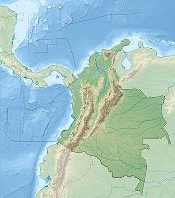
The Venado Formation (Spanish: Formación Venado, Oir) is a geological formation of the Agua Blanca Group, in the Eastern Ranges of the Colombian Andes, cropping out along the Venado River in northern Huila. The sequence of pyrite containing dark grey micaceous shales interbedded with siltstones and sandstones dates to the Ordovician period; Middle to Late Floian epoch, and has a maximum thickness of 670 metres (2,200 ft) in the type section.
| Venado Formation Stratigraphic range: Mid-Late Floian ~475–470 Ma | |
|---|---|
| Type | Geological formation |
| Unit of | Agua Blanca Group |
| Underlies | Saldaña Formation |
| Overlies | Basement |
| Thickness | up to 670 m (2,200 ft) |
| Lithology | |
| Primary | Shale |
| Other | Siltstone, sandstone, pyrite |
| Location | |
| Coordinates | 3°13′21.3″N 74°52′01.4″W |
| Region | Eastern Ranges, Andes |
| Country | |
| Type section | |
| Named for | Venado River |
| Named by | Villarroel et al. |
| Location | Baraya |
| Year defined | 1997 |
| Coordinates | 3°13′21.3″N 74°52′01.4″W |
| Region | Huila |
| Country | |
| Thickness at type section | 670 m (2,200 ft) |
The unit is one of the few Early Paleozoic fossiliferous formations of Colombia; many graptolites of the genus Phyllograptus have been found in the Venado Formation. The graptolites are mostly found in the silty beds and indicative of a fair weather environment on a siliciclastic shallow marine platform at the northern edge of Gondwana. The shallow sea where the Venado Formation was deposited ranged into the deeper cold Iapetus and Rheic Oceans, separating the South American continent of the time from Laurentia, Avalonia and Baltica.
Etymology
The formation was first described by Villarroel et al. in 1997 and named after the Venado River, a left tributary of the Cabrera River.[1][2]
Description

The Venado Formation is one of few Ordovician formations outcropping in Colombia. The formation, part of the Agua Blanca Group,[3] crops out on both banks of the Venado River in El Totumo, a vereda of the municipality Baraya in the department of Huila.[4] The thickness of the Venado Formation proper at its type section is 670 metres (2,200 ft), put in faulted contact with an overlying 30 metres (98 ft) thin unit and an underlying 50 metres (160 ft) sequence.[1] The series is unconformably overlain by the Jurassic Saldaña Formation.[1][5] The Venado Formation has been correlated to the contemporaneous El Hígado Formation of the Central Ranges in Tarqui.[6][7]
Lithologies
The Venado Formation comprises laminated dark grey micaceaous shales, with intercalating siltstone levels and very fine sandstone beds. Calcareous concretions up to 1 metre (3.3 ft) in diameter are present. The shales frequently contain aggregates of pyrite. The formation is heavily folded and in a faulted contact with the Cretaceous Caballos Formation,[3] at time of definition of the Venado Formation considered part of the Villeta Group.[8]
Depositional environment
The Venado Formation was deposited in a shallow marine environment, on a siliciclastic platform with persistent normal wave action with repetitive storm wave activity.[9] Anoxic conditions of the shallow sea probably led to the deposition of pyrite. The siltstone layers contain fragmented fossils of graptolites and are probably indicative of a fair weather environment and the coarser sediments resulted from episodic and rhythmic storms.[10]
Paleogeography

During the Ordovician, the present-day area of northwestern South America was located in the southern temperate region. The cold[11] Iapetus Ocean to the north of the South American terrane separated the landmass from Laurentia, most of present-day North America. The Rheic Ocean separated South America from the paleocontinents Baltica and Avalonia, that today is part of northeastern North America and northwestern Europe. North of the emerged continent of Gondwana, a shallow sea existed, bordering the Guyana and Brazilian Shields comprising the oldest crustal parts of the current South American continent.[11] During this time in the Ordovician, Gondwana was experiencing an orogeny; the Famatinian orogeny, when the Iapetus Plate was subducting beneath Gondwana.[12]
Fossil content
Fossiliferous formations of the Early Paleozoic are rare in Colombia. Apart from the Venado Formation, El Hígado Formation of the Central Ranges also in Huila, has provided fossils dating to the Ordovician, the Cambrian Duda Formation of the Serranía de Macarena in Meta contains fossils of the trilobite Paradoxides,[13] and the westernmost Ordovician unit in Colombia, La Cristalina Formation in the Central Ranges of eastern Antioquia that provided four species of Didymograptus.[14]
The formation has provided many fossils of graptolites; the most frequently occurring genus is Phyllograptus.[15] Additionally, Villarroel et al. (1997) reported having found Lingulella sp. and Didymograptus cf. D. artus in the formation.[5][9] The latter graptolite genus fossils have been assigned rather to Acrograptus filiformis by Gutiérrez Marco in 2006.[16]
Regional correlations
| Ma | Age | Paleomap | Regional events | Catatumbo | Cordillera | proximal Llanos | distal Llanos | Putumayo | VSM | Environments | Maximum thickness | Petroleum geology | Notes |
|---|---|---|---|---|---|---|---|---|---|---|---|---|---|
| 0.01 | Holocene | 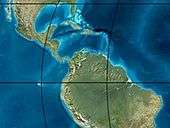 | Holocene volcanism Seismic activity | alluvium | Overburden | ||||||||
| 1 | Pleistocene | 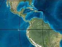 | Pleistocene volcanism Andean orogeny 3 Glaciations | Guayabo | Soatá Sabana | Necesidad | Guayabo | Gigante Neiva | Alluvial to fluvial (Guayabo) | 550 m (1,800 ft) (Guayabo) | [17][18][19][20] | ||
| 2.6 | Pliocene | 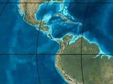 | Pliocene volcanism Andean orogeny 3 GABI | Subachoque | |||||||||
| 5.3 | Messinian | Andean orogeny 3 Foreland | Marichuela | Caimán | Honda | [19][21] | |||||||
| 13.5 | Langhian | Regional flooding | León | hiatus | Caja | León | Lacustrine (León) | 400 m (1,300 ft) (León) | Seal | [20][22] | |||
| 16.2 | Burdigalian | Miocene inundations Andean orogeny 2 | C1 | Carbonera C1 | Ospina | Proximal fluvio-deltaic (C1) | 850 m (2,790 ft) (Carbonera) | Reservoir | [21][20] | ||||
| 17.3 | C2 | Carbonera C2 | Distal lacustrine-deltaic (C2) | Seal | |||||||||
| 19 | C3 | Carbonera C3 | Proximal fluvio-deltaic (C3) | Reservoir | |||||||||
| 21 | Early Miocene | Pebas wetlands | C4 | Carbonera C4 | Barzalosa | Distal fluvio-deltaic (C4) | Seal | ||||||
| 23 | Late Oligocene | 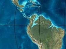 | Andean orogeny 1 Foredeep | C5 | Carbonera C5 | Orito | Proximal fluvio-deltaic (C5) | Reservoir | [18][21] | ||||
| 25 | C6 | Carbonera C6 | Distal fluvio-lacustrine (C6) | Seal | |||||||||
| 28 | Early Oligocene | C7 | C7 | Pepino | Gualanday | Proximal deltaic-marine (C7) | Reservoir | [18][21][23] | |||||
| 32 | Oligo-Eocene | C8 | Usme | C8 | onlap | Marine-deltaic (C8) | Seal Source | [23] | |||||
| 35 | Late Eocene | 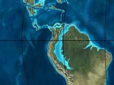 | Mirador | Mirador | Coastal (Mirador) | 240 m (790 ft) (Mirador) | Reservoir | [20][24] | |||||
| 40 | Middle Eocene | Regadera | hiatus | ||||||||||
| 45 | |||||||||||||
| 50 | Early Eocene |  | Socha | Los Cuervos | Deltaic (Los Cuervos) | 260 m (850 ft) (Los Cuervos) | Seal Source | [20][24] | |||||
| 55 | Late Paleocene | PETM 2000 ppm CO2 | Los Cuervos | Bogotá | Gualanday | ||||||||
| 60 | Early Paleocene | SALMA | Barco | Guaduas | Barco | Rumiyaco | Fluvial (Barco) | 225 m (738 ft) (Barco) | Reservoir | [17][18][21][20][25] | |||
| 65 | Maastrichtian |  | KT extinction | Catatumbo | Guadalupe | Monserrate | Deltaic-fluvial (Guadalupe) | 750 m (2,460 ft) (Guadalupe) | Reservoir | [17][20] | |||
| 72 | Campanian | End of rifting | Colón-Mito Juan | [20][26] | |||||||||
| 83 | Santonian | Villeta/Güagüaquí | |||||||||||
| 86 | Coniacian | ||||||||||||
| 89 | Turonian | Cenomanian-Turonian anoxic event | La Luna | Chipaque | Gachetá | hiatus | Restricted marine (all) | 500 m (1,600 ft) (Gachetá) | Source | [17][20][27] | |||
| 93 | Cenomanian |  | Rift 2 | ||||||||||
| 100 | Albian | Une | Une | Caballos | Deltaic (Une) | 500 m (1,600 ft) (Une) | Reservoir | [21][27] | |||||
| 113 | Aptian |  | Capacho | Fómeque | Motema | Yaví | Open marine (Fómeque) | 800 m (2,600 ft) (Fómeque) | Source (Fóm) | [18][20][28] | |||
| 125 | Barremian | High biodiversity | Aguardiente | Paja | Shallow to open marine (Paja) | 940 m (3,080 ft) (Paja) | Reservoir | [17] | |||||
| 129 | Hauterivian |  | Rift 1 | Tibú- Mercedes | Las Juntas | hiatus | Deltaic (Las Juntas) | 910 m (2,990 ft) (Las Juntas) | Reservoir (LJun) | [17] | |||
| 133 | Valanginian | Río Negro | Cáqueza Macanal Rosablanca | Restricted marine (Macanal) | 2,935 m (9,629 ft) (Macanal) | Source (Mac) | [18][29] | ||||||
| 140 | Berriasian | Girón | |||||||||||
| 145 | Tithonian | Break-up of Pangea | Jordán | Arcabuco | Buenavista Batá | Saldaña | Alluvial, fluvial (Buenavista) | 110 m (360 ft) (Buenavista) | "Jurassic" | [21][30] | |||
| 150 | Early-Mid Jurassic | 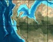 | Passive margin 2 | La Quinta | Montebel Noreán | hiatus | Coastal tuff (La Quinta) | 100 m (330 ft) (La Quinta) | [31] | ||||
| 201 | Late Triassic | 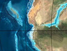 | Mucuchachi | Payandé | [21] | ||||||||
| 235 | Early Triassic | 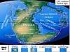 | Pangea | hiatus | "Paleozoic" | ||||||||
| 250 | Permian | 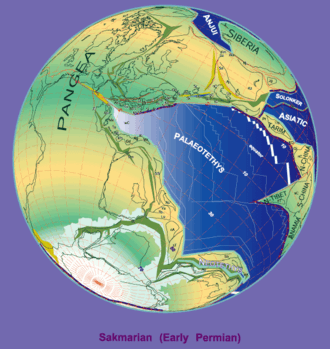 | |||||||||||
| 300 | Late Carboniferous |  | Famatinian orogeny | Cerro Neiva () | [32] | ||||||||
| 340 | Early Carboniferous | Fossil fish Romer's gap | Cuche (355-385) | Farallones () | Deltaic, estuarine (Cuche) | 900 m (3,000 ft) (Cuche) | |||||||
| 360 | Late Devonian |  | Passive margin 1 | Río Cachirí (360-419) | Ambicá () | Alluvial-fluvial-reef (Farallones) | 2,400 m (7,900 ft) (Farallones) | [29][33][34][35][36] | |||||
| 390 | Early Devonian |  | High biodiversity | Floresta (387-400) El Tíbet | Shallow marine (Floresta) | 600 m (2,000 ft) (Floresta) | |||||||
| 410 | Late Silurian | Silurian mystery | |||||||||||
| 425 | Early Silurian | hiatus | |||||||||||
| 440 | Late Ordovician | 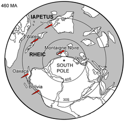 | Rich fauna in Bolivia | San Pedro (450-490) | Duda () | ||||||||
| 470 | Early Ordovician | First fossils | Busbanzá (>470±22) Chuscales Otengá | Guape () | Río Nevado () | Hígado () | [37][38][39] | ||||||
| 488 | Late Cambrian |  | Regional intrusions | Chicamocha (490-515) | Quetame () | Ariarí () | SJ del Guaviare (490-590) | San Isidro () | [40][41] | ||||
| 515 | Early Cambrian | Cambrian explosion | [39][42] | ||||||||||
| 542 | Ediacaran | 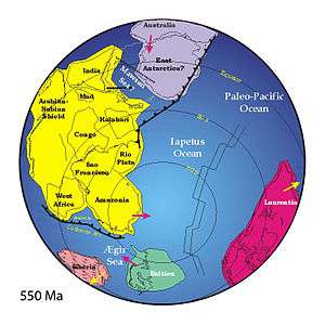 | Break-up of Rodinia | pre-Quetame | post-Parguaza | El Barro () | Yellow: allochthonous basement (Chibcha Terrane) Green: autochthonous basement (Río Negro-Juruena Province) | Basement | [43][44] | ||||
| 600 | Neoproterozoic | 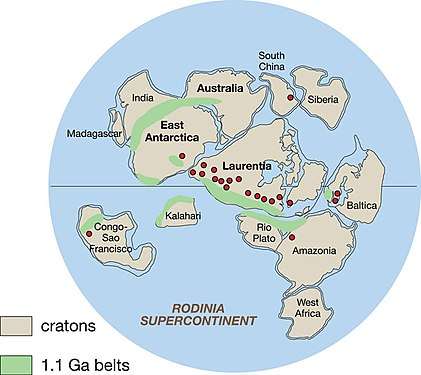 | Cariri Velhos orogeny | Bucaramanga (600-1400) | pre-Guaviare | [40] | |||||||
| 800 |  | Snowball Earth | [45] | ||||||||||
| 1000 | Mesoproterozoic |  | Sunsás orogeny | Ariarí (1000) | La Urraca (1030-1100) | [46][47][48][49] | |||||||
| 1300 | Rondônia-Juruá orogeny | pre-Ariarí | Parguaza (1300-1400) | Garzón (1180-1550) | [50] | ||||||||
| 1400 |  | pre-Bucaramanga | [51] | ||||||||||
| 1600 | Paleoproterozoic | Maimachi (1500-1700) | pre-Garzón | [52] | |||||||||
| 1800 |  | Tapajós orogeny | Mitú (1800) | [50][52] | |||||||||
| 1950 | Transamazonic orogeny | pre-Mitú | [50] | ||||||||||
| 2200 | Columbia | ||||||||||||
| 2530 | Archean |  | Carajas-Imataca orogeny | [50] | |||||||||
| 3100 | Kenorland | ||||||||||||
| Sources | |||||||||||||
- Legend
- group
- important formation
- fossiliferous formation
- minor formation
- (age in Ma)
- proximal Llanos (Medina)[note 1]
- distal Llanos (Saltarin 1A well)[note 2]
See also
- List of fossiliferous stratigraphic units in Colombia
- Geology of the Eastern Hills
- Geology of the Altiplano Cundiboyacense
- Iscayachi Formation, contemporaneous fossiliferous formation of Bolivia
- Pircancha Formation, contemporaneous fossiliferous formation of Bolivia
- San Lorenzo Formation, contemporaneous fossiliferous formation of Bolivia
- San Juan Formation, contemporaneous fossiliferous formation of Argentina
- Great Ordovician biodiversification event
Notes
References
- Villarroel et al., 1997, p.42
- Moreno Sánchez, 2008, p.10
- Plancha 303, 2002
- Moreno Sánchez, 2008, p.11
- Moreno Sánchez, 2008, p.13
- Moreno Sánchez, 2008, p.9
- Borrero et al., 2007, p.44
- Villarroel et al., 1997, p.43
- Villarroel et al., 1997, p.46
- Villarroel et al., 1997, p.47
- Moreno Sánchez, 2008, p.14
- Chernicoff et al., 2010, p.679
- Toro Toro et al., 2014, p.16
- González, 2001, p.49
- Moreno Sánchez, 2008, p.12
- Moreno Sánchez, 2008, p.16
- García González et al., 2009, p.27
- García González et al., 2009, p.50
- García González et al., 2009, p.85
- Barrero et al., 2007, p.60
- Barrero et al., 2007, p.58
- Plancha 111, 2001, p.29
- Plancha 177, 2015, p.39
- Plancha 111, 2001, p.26
- Plancha 111, 2001, p.24
- Plancha 111, 2001, p.23
- Pulido & Gómez, 2001, p.32
- Pulido & Gómez, 2001, p.30
- Pulido & Gómez, 2001, pp.21-26
- Pulido & Gómez, 2001, p.28
- Correa Martínez et al., 2019, p.49
- Plancha 303, 2002, p.27
- Terraza et al., 2008, p.22
- Plancha 229, 2015, pp.46-55
- Plancha 303, 2002, p.26
- Moreno Sánchez et al., 2009, p.53
- Mantilla Figueroa et al., 2015, p.43
- Manosalva Sánchez et al., 2017, p.84
- Plancha 303, 2002, p.24
- Mantilla Figueroa et al., 2015, p.42
- Arango Mejía et al., 2012, p.25
- Plancha 350, 2011, p.49
- Pulido & Gómez, 2001, pp.17-21
- Plancha 111, 2001, p.13
- Plancha 303, 2002, p.23
- Plancha 348, 2015, p.38
- Planchas 367-414, 2003, p.35
- Toro Toro et al., 2014, p.22
- Plancha 303, 2002, p.21
- Bonilla et al., 2016, p.19
- Gómez Tapias et al., 2015, p.209
- Bonilla et al., 2016, p.22
- Duarte et al., 2019
- García González et al., 2009
- Pulido & Gómez, 2001
- García González et al., 2009, p.60
Bibliography
- Borrero, C.; G.N. Sarmiento; C. Gómez González, and J.C. Gutiérrez Marco. 2007. Los Conodontos de la Formación El Hígado y su contribución al conocimiento del metamorfismo y la paleogeografía del Ordovícico en la Cordillera Central Colombiana. Boletín de Geología 29. 39–46. Accessed 2019-03-07.
- Chernicoff, Carlos J.; Eduardo O. Zappettini; João O.S. Santos; Shelley Allchurch, and Neal J. McNaughton. 2010. The southern segment of the Famatinian magmatic arc, La Pampa Province, Argentina. Gondwana Research 17. 662–675. Accessed 2019-03-07.
- González, Humberto. 2001. Mapa Geológico del Departamento de Antioquia - 1:400,000 - Memoria explicativa, 1–120. INGEOMINAS.
- Moreno Sánchez, Mario; Arley de Jesus Gómez Cruz, and Hardany Castillo González. 2008. Graptolitos del Ordovícico y geología de los afloramientos del Río Venado (norte del Departamento del Huila). Boletín de Geología 30. 9–19. Accessed 2019-03-07.
- Toro Toro, Luz Mary; Mario Moreno Sánchez, and Arley Gómez Cruz. 2014. Metagabro del Ariarí, plutonismo MORB, Cordillera Oriental de Colombia. Boletín de Geología 36. _. Accessed 2019-03-07.
- Villarroel A., C.; C. Macia S., and J. Brieva B. 1997. Formación Venado, nueva unidad litoestratigráfica del Ordovícico colombiano. Geología Colombiana 22. 41–49. Accessed 2019-03-07.
Maps
- Acosta, Jorge; Pablo Caro; Jaime Fuquen, and José Osorno. 2002. Plancha 303 - Colombia - 1:100,000, 1. INGEOMINAS.
External links
Paleontology in Colombia | |||||||||||||||||||||||||||
|---|---|---|---|---|---|---|---|---|---|---|---|---|---|---|---|---|---|---|---|---|---|---|---|---|---|---|---|
| Notable researchers |
|   .jpg)  | |||||||||||||||||||||||||
| Major fossiliferous stratigraphic units |
| ||||||||||||||||||||||||||
| Notable fossils |
| ||||||||||||||||||||||||||