Squaw Valley, Fresno County, California
Squaw Valley (formerly, Squawvalley)[6] is a census-designated place located in Fresno County, California, in the United States. As of the 2010 census, the CDP had a total population of 3,162, up from 2,691 at the 2000 census. Despite the similar name, it is not the location of Squaw Valley Ski Resort or the 1960 Winter Olympics. Squaw Valley is located 9 miles (14 km) north-northeast of Orange Cove and 30 miles (48 km) east of Fresno, at an elevation of 1,631 ft (497 m).[5] The name is controversial because squaw is an ethnic and sexual slur, historically used for indigenous North American women.[7][8][9][10]
Squaw Valley | |
|---|---|
 The Post Office in Squaw Valley along Highway 180 | |
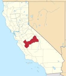
 Location in Fresno County and the state of California | |
 Squaw Valley Location in the United States | |
| Coordinates: 36°44′25″N 119°14′48″W | |
| Country | |
| State | |
| County | Fresno |
| Government | |
| • State Senator | Andreas Borgeas (R)[1] |
| • State Assembly | Jim Patterson (R)[2] |
| • U. S. Congress | Tom McClintock (R)[3] |
| Area | |
| • Total | 56.610 sq mi (146.618 km2) |
| • Land | 56.559 sq mi (146.487 km2) |
| • Water | 0.051 sq mi (0.131 km2) 0.09% |
| Elevation | 1,631 ft (497 m) |
| Population (2010) | |
| • Total | 3,162 |
| • Density | 56/sq mi (22/km2) |
| Time zone | UTC-8 (PST) |
| • Summer (DST) | UTC-7 (PDT) |
| ZIP codes | 93646, 93675 |
| Area code(s) | 559 |
| GNIS feature IDs | 1659853, 2408799 |
Geography
According to the United States Census Bureau, the CDP has a total area of 56.6 square miles (146.6 km2), of which over 99% is land.
History
The first post office opened in Squaw Valley in 1879.[6] The name was changed to Squawvalley in 1895.[6] The post office closed in 1918.[6] The post office was re-established in 1923, the name changed back to Squaw Valley in 1932, and closed again in 1945.[6] The post office re-opened in 1960.[6]
Demographics
2010
At the 2010 census Squaw Valley had a population of 3,162. The population density was 55.9 people per square mile (21.6/km2). The racial makeup of Squaw Valley was 2,700 (85.4%) White, 30 (0.9%) African American, 77 (2.4%) Native American, 47 (1.5%) Asian, 2 (0.1%) Pacific Islander, 159 (5.0%) from other races, and 147 (4.6%) from two or more races. Hispanic or Latino of any race were 525 people (16.6%).[11]
The census reported that 3,160 people (99.9% of the population) lived in households, 2 (0.1%) lived in non-institutionalized group quarters, and no one was institutionalized.
There were 1,188 households, 343 (28.9%) had children under the age of 18 living in them, 715 (60.2%) were married couples living together, 101 (8.5%) had a female householder with no husband present, 66 (5.6%) had a male householder with no wife present. There were 75 (6.3%) unmarried opposite-sex partnerships, and 7 (0.6%) same-sex married couples or partnerships. 239 households (20.1%) were one person and 99 (8.3%) had someone living alone who was 65 or older. The average household size was 2.66. There were 882 families (74.2% of households); the average family size was 3.01.
The age distribution was 709 people (22.4%) under the age of 18, 200 people (6.3%) aged 18 to 24, 597 people (18.9%) aged 25 to 44, 1,111 people (35.1%) aged 45 to 64, and 545 people (17.2%) who were 65 or older. The median age was 46.3 years. For every 100 females, there were 103.2 males. For every 100 females age 18 and over, there were 99.9 males.
There were 1,419 housing units at an average density of 25.1 per square mile (9.7/km2),of which 1,188 were occupied, 1,009 (84.9%) by the owners and 179 (15.1%) by renters. The homeowner vacancy rate was 3.6%; the rental vacancy rate was 5.7%. 2,648 people (83.7% of the population) lived in owner-occupied housing units and 512 people (16.2%) lived in rental housing units.
2000
As of the census[12] of 2000, there were 2,691 people, 1,025 households, and 779 families in the CDP. The population density was 47.5 people per square mile (18.3/km2). There were 1,160 housing units at an average density of 20.5 per square mile (7.9/km2). The racial makeup of the CDP was 88.33% White, 1.37% African American, 2.38% Native American, 0.56% Asian, 0.22% Pacific Islander, 4.83% from other races, and 2.30% from two or more races. 12.15% of the population were Hispanic or Latino of any race.
Of the 1,025 households 26.5% had children under the age of 18 living with them, 63.9% were married couples living together, 8.2% had a female householder with no husband present, and 24.0% were non-families. 19.3% of households were one person and 8.7% were one person aged 65 or older. The average household size was 2.62 and the average family size was 2.98.
The age distribution was 23.5% under the age of 18, 5.6% from 18 to 24, 23.7% from 25 to 44, 30.9% from 45 to 64, and 16.3% 65 or older. The median age was 44 years. For every 100 females, there were 97.3 males. For every 100 females age 18 and over, there were 97.4 males.
The median household income was $39,417 and the median family income was $47,739. Males had a median income of $38,375 versus $27,850 for females. The per capita income for the CDP was $20,719. 8.9% of the population and 2.6% of families were below the poverty line. 14.4% of those under the age of 18 and 2.1% of those 65 and older were living below the poverty line.
References
- "Senators". State of California. Retrieved April 6, 2013.
- "Members Assembly". State of California. Retrieved April 6, 2013.
- "California's 4th Congressional District - Representatives & District Map". Civic Impulse, LLC. Retrieved April 6, 2013.
- "2010 Census U.S. Gazetteer Files – Places – California". United States Census Bureau.
- "Squaw Valley". Geographic Names Information System. United States Geological Survey.
- Durham, David L. (1998). California's Geographic Names: A Gazetteer of Historic and Modern Names of the State. Clovis, Calif.: Word Dancer Press. p. 1109. ISBN 1-884995-14-4.
- National Museum of the American Indian (2007). Do All Indians Live in Tipis?. New York: HarperCollins. ISBN 978-0-06-115301-3.
- Schulman, Susan (16 Jan 2015). "Squaw Island to be renamed 'Deyowenoguhdoh'". The Buffalo News. Retrieved 14 April 2019.
The proposed name change comes at the request of Native Americans, who say the word "squaw" is a racist, sexist term
- Arlene B. Hirschfelder; Paulette Fairbanks Molin (2012). The Extraordinary Book of Native American Lists. Scarecrow. p. 34. ISBN 978-0-8108-7709-2.
- King, C. Richard, "De/Scribing Squ*w: Indigenous Women and Imperial Idioms in the United States" in the American Indian Culture and Research Journal, v27 n2 p1-16 2003. Accessed Oct. 9, 2015
- "2010 Census Interactive Population Search: CA - Squaw Valley CDP". U.S. Census Bureau. Archived from the original on July 15, 2014. Retrieved July 12, 2014.
- "U.S. Census website". United States Census Bureau. Retrieved 2008-01-31.