Mercey Hot Springs, California
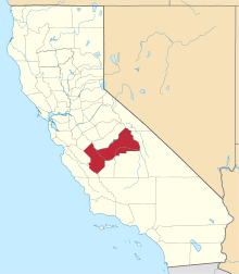
Mercey Hot Springs (formerly, Mercy Hot Springs) is an unincorporated community in the Little Panoche Valley of Fresno County, central California,[1] about 60 miles (97 km) west-southwest of Fresno.[2] It is a resort along South Fork Little Panoche Creek and the Little Panoche Road (Fresno County Road J1) located at the western edge of Fresno County.
Mercey Hot Springs | |
|---|---|
 | |
 Mercey Hot Springs Location in California | |
| Coordinates: 36°42′15″N 120°51′37″W | |
| Country | United States |
| State | California |
| County | Fresno County |
| Elevation | 1,161 ft (354 m) |
The unincorporated area is about ten driving miles west of Interstate 5. NAD83 latitude and longitude for the site are listed as 36°42′15″N 120°51′37″W in the National Geographic Names Database (NGND).[1] The NGND shows a feature ID number of 1659109. The facility is along the San Andreas Rift Zone.
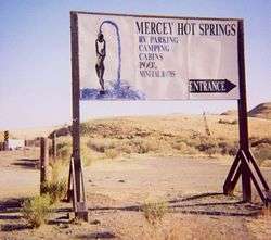
Located in the Little Panoche Valley, the facility includes a campground and natural hot springs. The ZIP Code is 93622, and the community is inside area code 559. It lies at an elevation of 1,161 ft (354 m).[1]
History
The springs were discovered on the Arroyo de Pannochita in 1848.[2] During the California Gold Rush it was known as the Aguaje Panochita. This watering place was used by mesteneros as holding point for their captured mustangs. It was a station on La Vereda del Monte used by the Five Joaquins Gang driving their horses southward to their hideout on the Arroyo de Cantua.[3]:449,453 The later resort opened after 1900.[2] The name is in honor of J.N. Mercy, an early stockman.[2]
Nearby
About 7 miles (11 km) south, in San Benito County near the intersection of Panoche Road and Little Panoche Road, is the Panoche Inn. The bar is popular with motorcyclists on weekends in good weather. NAD27 latitude and longitude for the Inn are 36°36′25″N 120°53′07″W.
Four miles northwest, the county lines for Merced County, San Benito County, and Fresno form a "T".
Path 15, a major electric transmission corridor in California, runs approximately five miles to the east of the resort.
Five miles to the south in the Panoche Valley is the Panoche Valley Solar Farm.
References
- U.S. Geological Survey Geographic Names Information System: Mercey Hot Springs, California
- Durham, David L. (1998). California's Geographic Names: A Gazetteer of Historic and Modern Names of the State. Clovis, Calif.: Word Dancer Press. p. 1071. ISBN 1-884995-14-4.
- Frank F. Latta, JOAQUIN MURRIETA AND HIS HORSE GANGS, Bear State Books, Santa Cruz, California. 1980.
External links
- Official Mercey Hot Springs Resort website
- BLM web page for Panoche Hills.
- Nearby Little Panoche Reservoir.
- US Bureau of Reclamation Panoche Dam page.