Seabrook, New Hampshire
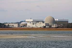
Seabrook is a town in Rockingham County, New Hampshire, United States. The population was 8,693 at the 2010 census.[1] Located at the southern end of the coast of New Hampshire on the border with Massachusetts, Seabrook is noted as the location of the Seabrook Nuclear Power Station, the third-most recently constructed nuclear power plant in the United States.
Seabrook, New Hampshire | |
|---|---|
Town | |
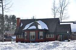 The public library, old portion | |
 Seal | |
 Location in Rockingham County and the state of New Hampshire. | |
| Coordinates: 42°53′37″N 70°52′24″W | |
| Country | United States |
| State | New Hampshire |
| County | Rockingham |
| Incorporated | June 3, 1768 |
| Villages | Seabrook Seabrook Beach Seabrook Station Smithtown South Seabrook Weare Corner |
| Government | |
| • Board of Selectmen | Theresa A. Kyle, Chair Ella M. Brown Aboul B. Khan |
| • Town Manager | William M. Manzi III |
| Area | |
| • Total | 9.6 sq mi (24.9 km2) |
| • Land | 8.9 sq mi (22.9 km2) |
| • Water | 0.8 sq mi (1.9 km2) 7.80% |
| Elevation | 56 ft (21 m) |
| Population (2010) | |
| • Total | 8,693 |
| • Density | 977/sq mi (377/km2) |
| Time zone | UTC-5 (Eastern) |
| • Summer (DST) | UTC-4 (Eastern) |
| ZIP code | 03874 |
| Area code(s) | 603 |
| FIPS code | 33-68260 |
| GNIS feature ID | 0873718 |
| Website | www |
Geography
According to the United States Census Bureau, the town has a total area of 9.6 square miles (25 km2), of which 8.9 sq mi (23 km2) is land and 0.8 sq mi (2.1 km2) is water, comprising 7.8% of the town. The census-designated place of Seabrook Beach occupies the eastern end of the town, along the Atlantic Ocean. The highest point in Seabrook is 217 feet (66 m) above sea level on Grape Hill, whose 230-foot (70 m) summit lies just south of the town line in Salisbury, Massachusetts.
Adjacent municipalities
- Hampton Falls, New Hampshire (north)
- Hampton, New Hampshire (northeast)
- Salisbury, Massachusetts (south)
- South Hampton, New Hampshire (west)
- Kensington, New Hampshire (northwest)
Demographics
| Historical population | |||
|---|---|---|---|
| Census | Pop. | %± | |
| 1790 | 715 | — | |
| 1800 | 628 | −12.2% | |
| 1810 | 774 | 23.2% | |
| 1820 | 885 | 14.3% | |
| 1830 | 1,096 | 23.8% | |
| 1840 | 1,392 | 27.0% | |
| 1850 | 1,266 | −9.1% | |
| 1860 | 1,549 | 22.4% | |
| 1870 | 1,609 | 3.9% | |
| 1880 | 1,745 | 8.5% | |
| 1890 | 1,672 | −4.2% | |
| 1900 | 1,497 | −10.5% | |
| 1910 | 1,425 | −4.8% | |
| 1920 | 1,537 | 7.9% | |
| 1930 | 1,666 | 8.4% | |
| 1940 | 1,782 | 7.0% | |
| 1950 | 1,788 | 0.3% | |
| 1960 | 2,209 | 23.5% | |
| 1970 | 3,053 | 38.2% | |
| 1980 | 5,917 | 93.8% | |
| 1990 | 6,503 | 9.9% | |
| 2000 | 7,934 | 22.0% | |
| 2010 | 8,693 | 9.6% | |
| Est. 2017 | 8,854 | [2] | 1.9% |
| U.S. Decennial Census[3] | |||
As of the 2010 census, there were 8,693 people, 3,706 households and 2,276 families living in the town. The population density was 977 per square mile (380/km2). There were 4,544 housing units in the town, 838 of which (18.4%) were vacant. 512 of the vacant units were for seasonal or recreational use. The racial makeup of the town was 96.3% White, 0.5% African American, 0.1% Native American, 1.1% Asian, 0.6% some other race, and 1.4% from two or more races. Hispanic or Latino of any race were 1.4% of the population.[4]
Of the 3,706 households in the town, 25.4% had children under the age of 18 living with them, 45.0% were headed by married couples living together, 11.1% had a female householder with no husband present, and 38.6% were non-families. 30.1% of all households were made up of individuals, and 11.7% were someone living alone who was 65 years of age or older. The average household size was 2.34, and the average family size was 2.90.[4]
The town's age distribution was 18.7% under the age of 18, 7.8% from 18 to 24, 24.2% from 25 to 44, 31.7% from 45 to 64, and 17.5% who were 65 years of age or older. The median age was 44.6 years. For every 100 females, there were 99.0 males. For every 100 females age 18 and over, there were 98.4 males.[4]
For the period 2014-18, the estimated median household income was $67,430, and the median family income was $78,769. Male full-time workers had a median income of $53,315 versus $41,354 for females. The per capita income for the town was $35,356.[5]
Sites of interest
- Seabrook Station nuclear power plant
- Seabrook Beach
Notable people
- Alvah Augustus Eaton, botanist
- William Fowler, member of the New Hampshire House of Representatives
- Pamela Gidley, actress
- Scotty Lago, bronze medalist snowboarder (2010 Olympics)
- Jackson Nicoll, child actor
- Meshech Weare, New Hampshire's first President (now known as Governor)
References
| Wikimedia Commons has media related to Seabrook, New Hampshire. |
- United States Census Bureau, U.S. Census website, 2010 Census figures. Retrieved March 23, 2011.
- "Annual Estimates of the Resident Population: April 1, 2010 to July 1, 2017 (PEPANNRES): Minor Civil Divisions – New Hampshire". Archived from the original on February 13, 2020. Retrieved November 15, 2018.
- "Census of Population and Housing". Census.gov. Retrieved June 4, 2016.
- "Profile of General Population and Housing Characteristics: 2010 Census Summary File 1 (DP-1), Seabrook town, Rockingham County, New Hampshire". American FactFinder. U.S. Census Bureau. Archived from the original on February 13, 2020. Retrieved January 15, 2020.
- "Selected Economic Characteristics: American Community Survey 5-Year Estimates (DP03), Seabrook town, Rockingham County, New Hampshire". data.census.gov. U.S. Census Bureau. Retrieved January 15, 2020.
External links
- Town of Seabrook official website
- Seabrook Police Department
- Seabrook Library
- New Hampshire Economic and Labor Market Information Bureau Profile
Places adjacent to Seabrook, New Hampshire | |
|---|---|
Municipalities and communities of Rockingham County, New Hampshire, United States | ||
|---|---|---|
| City | 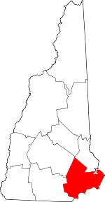 Map of New Hampshire highlighting Rockingham County | |
| Towns |
| |
| CDPs | ||
| Other villages | ||
| Authority control |
|
|---|