Sackville Parish, New Brunswick
Sackville is a civil parish[lower-alpha 1] in Westmorland County, New Brunswick, Canada.[2]
Sackville | |
|---|---|
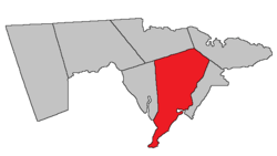 Location within Westmorland County, New Brunswick. | |
| Coordinates: 46.19°N 64.60°W | |
| Country | |
| Province | |
| County | Westmorland County |
| Established | 1786 |
| Area | |
| • Land | 579.98 km2 (223.93 sq mi) |
| Lowest elevation | 0 m (0 ft) |
| Population (2016)[1] | |
| • Total | 1,182 |
| • Density | 2.0/km2 (5/sq mi) |
| • Change 2011-2016 | |
| • Dwellings | 553 |
| Time zone | UTC-4 (AST) |
| • Summer (DST) | UTC-3 (ADT) |
| Area code(s) | 506 |
For governance purposes it is divided between the village of Sackville, the incorporated rural community of Beaubassin East;[3], and the local service district of the parish of Sackville.[4]
History
The parish was established as a Nova Scotia township in 1772: named for Lord George Sackville Germain, 1st Viscount Sackville (1716-1785) commander of the British forces and colonial secretary from 1775-1782: re-established as a New Brunswick parish in 1786: included parts of Botsford Parish until 1805 and Shediac Parish until 1827.
Delineation
Sackville Parish is defined in the Territorial Division Act[2] as being bounded:
- North by the north line of Dorchester Parish prolonged easterly to a point of intersection of the Cumberland grant line, which runs north thirty degrees and thirty minutes west by the magnet of eighteen hundred and sixty seven from the southeast angle of lot number one, granted to Otho Reed, at the mouth of Gaspereau Creek;[lower-alpha 2] west by Dorchester Parish and Chignecto Bay; south and east by Cumberland Basin and the Aulac River, from its mouth to the upper line of the Sackville grant; thence by a line running north by the magnet of the year seventeen hundred and sixty-five to a point on the said line one hundred and two chains southerly from where the road[lower-alpha 3] through Midgic leaves the said line at Edwin Dixon’s gate; thence running north fifty-seven degrees and thirty minutes east by the magnet of eighteen hundred and eighty to the channel of Big Jolicure Lake; thence along the said channel and main brook up stream[lower-alpha 4] to the prolongation southwestwardly of the southeast line of David Wheaton’s mill lot; thence along the said prolongation and line to the east angle of said Wheaton’s mill lot; thence north forty-five degrees east to the Botsford Parish line; northeast by Botsford Parish.
Communities
Parish population total does not include incorporated municipalities (in bold):
|
|
|
Demographics
Population
|
LanguageMother tongue (2016)[1]
| |||||||||||||||||||||||||||||||||||||||
Access routes
Highways and numbered routes that run through the parish, including external routes that start or finish at the parish limits:[8]
|
|
|
|
See also
Notes
- Civil parishes served a variety of government functions until 1966, when the new Municipalities Act stripped them of their responsibilities; they continue to provide convenient boundaries for government uses, especially electoral districts and local service districts. Statistics Canada uses civil parishes as census subdivisions for all parts of the province that are not within municipalities and similar entities.
- Now officially Gaspereau River.[5]
- Goose Lake Road
- Along Goose Creek and Robinson Brook
References
- "Census Profile, 2016 Census: Sackville, Parish [Census subdivision], New Brunswick". Statistics Canada. Retrieved October 5, 2019.
- "Chapter T-3 Territorial Division Act". Government of New Brunswick. Retrieved 23 July 2020.
- "New Brunswick Regulation 95-36 under the Municipalities Act (O.C. 95-342)". Government of New Brunswick. Retrieved 23 July 2020.
- "New Brunswick Regulation 84-168 under the Municipalities Act (O.C. 84-582)". Government of New Brunswick. Retrieved 23 July 2020.
- "Gaspereau River". Canadian Geographical Names. Natural Resources Canada. Retrieved 24 August 2016.
- Statistics Canada: 2001, 2006 census
- 2011 Statistics Canada Census Profile: Sackville Parish, New Brunswick
- Atlantic Canada Back Road Atlas ISBN 978-1-55368-618-7
External links
Places adjacent to Sackville Parish, New Brunswick | |
|---|---|
| Subdivisions |
|
|---|---|
| Cities | |
| Counties | |
| |