S postcode area
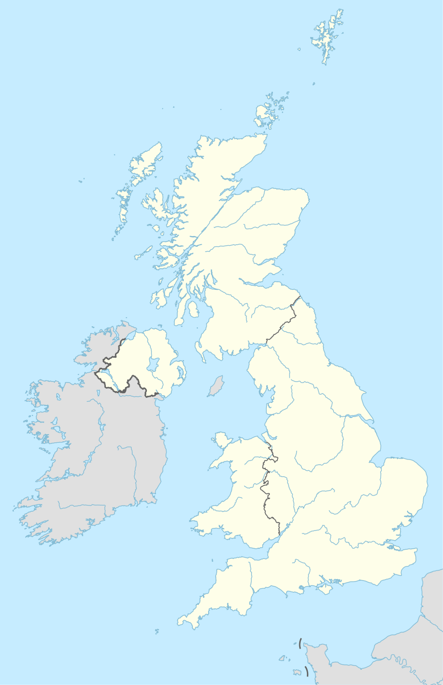
The S postcode area, also known as the Sheffield postcode area,[2] is a group of postcode districts in England, which are subdivisions of eight post towns. These cover most of South Yorkshire (post towns Sheffield, Barnsley, Rotherham and Mexborough), parts of north Derbyshire (post towns Chesterfield, Dronfield and the Hope Valley) and north-west Nottinghamshire (post town Worksop).
| Sheffield postcode area | |
|---|---|
 S | |
| Postcode area | S |
| Postcode area name | Sheffield |
| Post towns | 8 |
| Postcode districts | 52 |
| Postcode sectors | 248 |
| Postcodes (live) | 33,439 |
| Postcodes (total) | 49,099 |
| Statistics as at May 2020[1] | |
History
For 1857–1868 an S sector of the London postal district existed.
Similarly, there were also S-prefixed postal districts in the compass-based system used in Glasgow: Glasgow S1, S2, S3 and S4 areas changed to postcodes G41 to G44.
- S20 district was S19
- S21, S25 and S26 were S31
- S32 to S36 were S30.
S64, Mexborough post town, was earmarked for use as DN13 which has never been used, see DN postcode area.
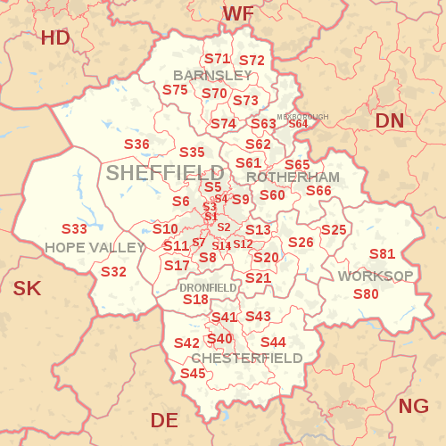
Coverage
The approximate coverage of the postcode districts:
| Postcode district | Post town | Coverage | Local authority area(s) |
|---|---|---|---|
| S1 | SHEFFIELD | Sheffield City Centre | Sheffield |
| S2 | SHEFFIELD | Arbourthorne, Heeley, Highfield, Manor, Norfolk Park, Wybourn, Park Hill | Sheffield |
| S3 | SHEFFIELD | Broomhall, Burngreave, Neepsend, Netherthorpe | Sheffield |
| S4 | SHEFFIELD | Grimesthorpe, Pitsmoor | Sheffield |
| S5 | SHEFFIELD | Firth Park, Fir Vale, Longley, Shirecliffe, Shiregreen, Southey Green, Parson Cross, Wincobank | Sheffield |
| S6 | SHEFFIELD | Bradfield, Dungworth, Hillsborough, Holdworth, Hollow Meadows, Loxley, Malin Bridge, Middlewood, Stannington, Storrs, Upperthorpe, Walkley, Wadsley Bridge, Wisewood, Wadsley, Fox Hill, | Sheffield |
| S7 | SHEFFIELD | Abbeydale, Carter Knowle, Nether Edge, Millhouses | Sheffield |
| S8 | SHEFFIELD | Batemoor, Beauchief, Greenhill, Jordanthorpe, Lowedges, Meersbrook, Norton, Norton Lees, Woodseats | Sheffield |
| S9 | SHEFFIELD | Attercliffe, Brightside, Darnall, Meadowhall, Tinsley, Wincobank | Sheffield |
| S10 | SHEFFIELD | Broomhill, Broomhall, Crookes, Crookesmoor, Crosspool, Fulwood, Ranmoor | Sheffield |
| S11 | SHEFFIELD | Ecclesall, Endcliffe Park, Ecclesall Road, Greystones, Hunter's Bar, Millhouses, Sharrow Vale, Nether Edge, Whirlow, Brincliffe | Sheffield |
| S12 | SHEFFIELD | Birley, Gleadless, Gleadless Townend, Frecheville, Hackenthorpe, Intake, Ridgeway | North East Derbyshire, Sheffield |
| S13 | SHEFFIELD | Fence, Handsworth, Richmond, Woodhouse | Rotherham, Sheffield |
| S14 | SHEFFIELD | Gleadless Valley | Sheffield |
| S17 | SHEFFIELD | Dore, Totley, Bradway | Sheffield |
| S18 | DRONFIELD | Coal Aston, Dronfield, Dronfield Woodhouse, Holmesfield, Unstone | North East Derbyshire |
| S20 | SHEFFIELD | Beighton, Crystal Peaks, Halfway, Mosborough, Owlthorpe, Sothall, Waterthorpe, Westfield, | Sheffield |
| S21 | SHEFFIELD | Eckington, Killamarsh, Renishaw, Spinkhill | North East Derbyshire |
| S25 | SHEFFIELD | Anston, Dinnington, Laughton-en-le-Morthen | Rotherham |
| S26 | SHEFFIELD | Aston, Aughton, Harthill, Kiveton Park, Swallownest, Todwick, Wales | Rotherham |
| S32 | HOPE VALLEY | Calver, Eyam, Grindleford, Hathersage, Stoney Middleton | Derbyshire Dales |
| S33 | HOPE VALLEY | Bamford, Bradwell, Castleton, Edale, Hope, Yorkshire Bridge | High Peak |
| S35 | SHEFFIELD | Chapeltown, Crane Moor, Ecclesfield, Grenoside, High Green, Oughtibridge, Thurgoland, Wharncliffe Side, Wortley | Sheffield |
| S36 | SHEFFIELD | Penistone, Thurlstone, Millhouse Green, Oxspring, Stocksbridge, Deepcar, Bolsterstone, Catshaw | Barnsley, Sheffield |
| S40 | CHESTERFIELD | Central and West Chesterfield, Brampton | Chesterfield |
| S41 | CHESTERFIELD | Hasland, North Chesterfield, Old Whittington | Chesterfield, North East Derbyshire |
| S42 | CHESTERFIELD | Holymoorside, Grassmoor, North Wingfield, Tupton, Wingerworth, Mastin Moor | Chesterfield, North East Derbyshire |
| S43 | CHESTERFIELD | Brimington, Barlborough, Clowne, Inkersall Green, Staveley | Bolsover, Chesterfield |
| S44 | CHESTERFIELD | Bolsover, Calow, Sutton cum Duckmanton, Scarcliffe | Bolsover, North East Derbyshire |
| S45 | CHESTERFIELD | Ashover, Clay Cross, Pilsley | North East Derbyshire |
| S49 | CHESTERFIELD | Bulk users | non-geographic |
| S60 | ROTHERHAM | Brinsworth, Catcliffe, Canklow, Clifton Central Rotherham, Masbrough, Moorgate, Treeton, Whiston | Rotherham |
| S61 | ROTHERHAM | Greasbrough, Kimberworth, Rockingham, Thorpe Hesley, Munsborough, Scholes, Ferham | Rotherham |
| S62 | ROTHERHAM | Rawmarsh, Wentworth, Parkgate | Rotherham |
| S63 | ROTHERHAM | Bolton-on-Dearne, Goldthorpe, Thurnscoe, Brampton, Wath-on-Dearne, West Melton | Barnsley, Rotherham |
| S64 | MEXBOROUGH | Mexborough, Swinton, Kilnhurst, Adwick Upon Dearne | Doncaster, Rotherham |
| S65 | ROTHERHAM | Herringthorpe, Hooton Roberts, Ravenfield, Thrybergh, East Dene | |
| S66 | ROTHERHAM | Bramley Hellaby, Maltby, Thurcroft, Wickersley, Braithwell | Rotherham |
| S70 | BARNSLEY | Central Barnsley, Birdwell, Stairfoot, Worsborough, Kendray | Barnsley |
| S71 | BARNSLEY | Ardsley, Athersley, Monk Bretton, Lundwood, Royston | Barnsley |
| S72 | BARNSLEY | Brierley, Cudworth, Grimethorpe, Shafton, South Hiendley | Barnsley, City of Wakefield |
| S73 | BARNSLEY | Darfield, Wombwell, Hemingfield | Barnsley, Rotherham |
| S74 | BARNSLEY | Elsecar, Hoyland, Jump, Blacker Hill | Barnsley |
| S75 | BARNSLEY | Barugh Green, Cawthorne, Darton, Dodworth, Gawber, Mapplewell, Pogmoor, Staincross, Wilthorpe, Tankersley, Kexborough | Barnsley |
| S80 | WORKSOP | Creswell, Thorpe Salvin, South Worksop, Whitwell | Bassetlaw, Bolsover, Rotherham |
| S81 | WORKSOP | Blyth, Carlton-in-Lindrick, Langold, North Worksop, Shireoaks, Woodsetts | Bassetlaw, Rotherham |
| S94 | SHEFFIELD | Census 2021 (a main national office) | non-geographic |
| S95 | SHEFFIELD | Bulk users | non-geographic |
| S96 | SHEFFIELD | Bulk users | non-geographic |
| S97 | ROTHERHAM, SHEFFIELD | Bulk users | non-geographic |
| S98 | SHEFFIELD | Bulk users | non-geographic |
| S99 | SHEFFIELD | Jobcentre Plus | non-geographic |
Map
References
- "ONS Postcode Directory Version Notes" (ZIP). National Statistics Postcode Products. Office for National Statistics. May 2020. Table 2. Retrieved 19 June 2020. Coordinates from mean of unit postcode points, "Code-Point Open". OS OpenData. Ordnance Survey. February 2012. Retrieved 21 April 2012.
- Royal Mail, Address Management Guide, (2004)