LU postcode area
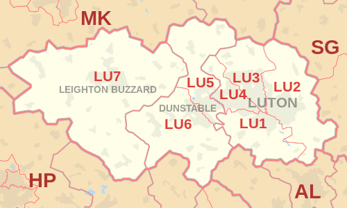
The LU postcode area, also known as the Luton postcode area,[2] is a group of seven postcode districts in England, within three post towns. These cover south Bedfordshire (including Luton, Dunstable and Leighton Buzzard), plus small parts of north Hertfordshire and central Buckinghamshire.
| Luton postcode area | |
|---|---|
 LU | |
| Postcode area | LU |
| Postcode area name | Luton |
| Post towns | 3 |
| Postcode districts | 8 |
| Postcode sectors | 36 |
| Postcodes (live) | 6,225 |
| Postcodes (total) | 10,358 |
| Statistics as at May 2020[1] | |
Coverage
The approximate coverage of the postcode districts:[3]
| Postcode district | Post town | Coverage | Local authority area(s) |
|---|---|---|---|
| LU1 | LUTON | Luton (South), Aley Green, Caddington, Lower Woodside, Pepperstock, Slip End, Woodside | Luton, Central Bedfordshire |
| LU2 | LUTON | Luton (East), Chiltern Green, Cockernhoe, East Hyde, Lawrence End, Lilley, New Mill End, Peters Green, Tea Green, The Hyde, Wandon End, Wandon Green, Winch Hill | Luton, Central Bedfordshire, North Hertfordshire |
| LU3 | LUTON | Luton (North), Lower Sundon, Streatley, Sundon | Luton, Central Bedfordshire |
| LU4 | LUTON | Luton (West), Chalton, London Farm, Bedfordshire | Luton, Central Bedfordshire |
| LU5 | DUNSTABLE | Dunstable (East including Woodside Estate), Bidwell, Chalgrave, Fancott, Harlington, Houghton Regis (including Townsend Industrial Estate), Thorn, Toddington | Central Bedfordshire, |
| LU6 | DUNSTABLE | Dunstable (West), Eaton Bray, Edlesborough, Holywell, Kensworth, Northall, Sewell, Studham, Totternhoe, Whipsnade | Central Bedfordshire, Aylesbury Vale |
| LU7 | LEIGHTON BUZZARD | Leighton Buzzard, Bragenham, Briggington, Burcott, Cheddington, Chelmscote, Clipstone, Crafton, Cublington, Eggington, Great Billington, Grove, Heath and Reach, Hockliffe, Horton, Hollingdon, Ivinghoe, Ivinghoe Aston, Ledburn, Leedon, Little Billington, Mentmore, Pitstone, Slapton, Soulbury, Stanbridge, Stewkley, Stockgrove, Tebworth, Tilsworth, Wing, Wingfield | Central Bedfordshire, Aylesbury Vale |
Map
References
- "ONS Postcode Directory Version Notes" (ZIP). National Statistics Postcode Products. Office for National Statistics. May 2020. Table 2. Retrieved 19 June 2020. Coordinates from mean of unit postcode points, "Code-Point Open". OS OpenData. Ordnance Survey. February 2012. Retrieved 21 April 2012.
- Royal Mail, Address Management Guide, (2004)
- Placenames as listed in Royal Mail, Postal Address Book: Anglia 2, Edition H, 2003.
External links
This article is issued from Wikipedia. The text is licensed under Creative Commons - Attribution - Sharealike. Additional terms may apply for the media files.