Rivière du Rempart District
Rivière du Rempart (Mauritian Creole pronunciation: [ʁivjɛː dʒi ʁɑ̃pɑː]) is a district of Mauritius, located in the North-East of the island, having an area of 147.6 km². The population estimate was at 108,005 as at 31 December 2015.[3]
Rivière du Rempart | |
|---|---|
 | |
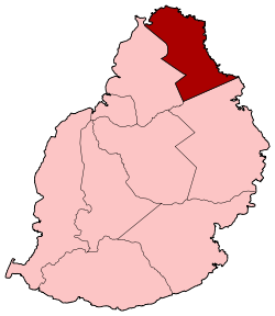 Map of Mauritius island with Rivière du Rempart District highlighted | |
| Coordinates: 20°03′S 57°38′E | |
| Country | |
| Government | |
| • Type | District Council |
| • Chairman | Mr. ELLAYAH Prembhoodas[2] |
| • Vice Chairman | Mr. KOOBARAWA Deokumar[2] |
| Area | |
| • Total | 147.6 km2 (57.0 sq mi) |
| Population (2015)[3] | |
| • Total | 108,005 |
| • Rank | 6th in Mauritius |
| • Density | 730/km2 (1,900/sq mi) |
| Time zone | UTC+4 (MUT) |
| ISO 3166 code | MU-RR (Rivière du Rempart) |
History
Places of interest
Places
The Rivière du Rempart District include different regions; however, some regions are further divided into different suburbs.[3][4]
- Amaury (Southern part in Flacq district)
- Amitié-Gokhoola (Western part in Pamplemousses district)
- Barlow
- Belle Vue Maurel
- Brisée-Verdière (Southern part in Flacq district)
- Cap Malheureux
- Cottage
- Espérance Trébuchet
- Goodlands
- Grand-Bay (Western part in Pamplemousses district)
- Grand-Gaube
- Le Vale
- Mapou (Southern part in Pamplemousses district)
- Panchavati
- Petit Raffray
- Piton (Western part in Pamplemousses district)
- Plaines des Roches (Southern part in Flacq district)
- Pointe de Lascars
- Poudre d'Or
- Poudre d'Or Hamlet
- Rivière-du-Rempart
- Roche-Terre
- Roches-Noires (Southern part in Flacq district)
- Villebague (Western part in Pamplemousses district and Southern part in Flacq district)
Education
List of secondary schools in Rivière du Rempart[5]
- Northfields International High School, Mapou.[6]
- Ramsoondur Prayag State Secondary School, Rivière du Rempart
- Simadree Virasawmy State Secondary School, Rivière du Rempart
- Universal College, Rivière du Rempart
- Ideal College, Rivière du Rempart
- Beekrumsing Ramlallah State Secondary School, Mapou Mapou
- Piton State College, Piton
- Sharma Jugdambi State Secondary School, Goodlands
- Goodlands State Secondary School (Boys), Goodlands
- Friendship College (Boys and Girls), Goodlands
- Adolf de Plevitz State Secondary School, Grand Bay
See also
| Wikimedia Commons has media related to Rivière du Rempart District. |
References
- "Archived copy". Archived from the original on 4 April 2014. Retrieved 8 March 2014.CS1 maint: archived copy as title (link)
- https://dcrempart.mu/list-of-district-councillors/
- Ministry of Finance & Economic Development (2016). "ANNUAL DIGEST OF STATISTICS 2015" (PDF). August. Government of Mauritius: 19. Retrieved 23 December 2016. Cite journal requires
|journal=(help) - Statistic office of Mauritius (2011). "Housing and population Census 2011" (PDF). Government of Mauritius. Archived from the original (PDF) on 21 October 2013. Retrieved 12 September 2012. Cite journal requires
|journal=(help) - List of secondary schools in Mauritius
- "Contact Us." Northfields International High School. Retrieved on May 4, 2015. "Address: Main Road Labourdonnais Village Mapou Mauritius"
Places adjacent to Rivière du Rempart District | ||||||||||
|---|---|---|---|---|---|---|---|---|---|---|
| ||||||||||
| Subdivisions |
| .svg.png) | ||||||||||||
|---|---|---|---|---|---|---|---|---|---|---|---|---|---|---|
| Politics |
| |||||||||||||
| Economy | ||||||||||||||
| Society |
| |||||||||||||
This article is issued from Wikipedia. The text is licensed under Creative Commons - Attribution - Sharealike. Additional terms may apply for the media files.