Rodrigues
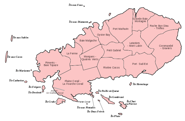
Rodrigues (French: Île Rodrigues [ʁɔdʁiɡ]; Creole: Rodrig) is a 108-square-kilometre (42 sq mi) autonomous outer island of the Republic of Mauritius in the Indian Ocean, about 560 kilometres (350 mi) east of Mauritius.[1] It is part of the Mascarene Islands which include Mauritius and Réunion. It is of volcanic origin and is surrounded by coral reef, and just off its coast lie some tiny uninhabited islands. The island used to be the tenth District of Mauritius; it gained autonomous status on 10 December 2002, and it is governed by the Rodrigues Regional Assembly. The capital of the island is Port Mathurin.
Rodrigues Rodrig (Morisyen) | |
|---|---|
Autonomous outer island | |
 Flag  Coat of arms | |
| Motto(s): | |
| Anthem: Motherland | |
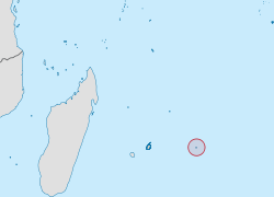 Location of Rodrigues in the Indian Ocean. | |
| Coordinates: 19°43′S 63°25′E | |
| Country | |
| Capital | Port Mathurin |
| Government | |
| • Body | Regional Assembly |
| • Chief Commissioner | Serge Clair |
| • Chief Executive | Davis Hee Hong Wye |
| • Minister for Rodrigues | Sir Anerood Jugnauth |
| Area | |
| • Total | 108 km2 (42 sq mi) |
| Population (2014)[note 1] | |
| • Total | 41,669 |
| • Estimate (2013) | 38,379[2] |
| • Density | 386/km2 (1,000/sq mi) |
| Demonym(s) | Rodriguan |
| Languages | |
| • Vernacular languages |
|
| Time zone | UTC+4 (MUT) |
| Calling code | +230 |
| Currency | Mauritian rupee (MUR) |
| Date format | dd/mm/yyyy (AD) |
| Drives on | left |
| Internet TLD | .mu |
Its inhabitants are Mauritian citizens. As of 2014, the island's population was about 41,669, according to Statistics Mauritius.[4] Most of the inhabitants are of mixed African and European descent. Its economy is based mainly on fishing, farming, handicraft and a developing tourism sector.[5]
The island (together with Agaléga and Saint Brandon) forms part of the larger territory of the Republic of Mauritius with the President as head of state and the Chief Commissioner as head of government.
Etymology and history
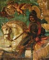
The uninhabited island was named after the Portuguese explorer Diogo Rodrigues in February 1528. Many maps also describe it as Diego Roiz. From the 10th century, Arabs have been known to visit the Mascarene Islands. A 12th-century map by the Arab geographer Ash-Sharif al-Idrisi supposedly contains them, and the Cantino planisphere of c. 1500 and some other contemporary maps clearly show the three islands of the Mascarenes as Dina Arobi (or Harobi), Dina Margabin and Dina Moraze. These are apparently corrupted transliterations or transcriptions of the Arabic ديفا هاراب Diva Harab ("Desert Island"), ديفا مغربين Diva Maghrebin ("Western Island") and ديفا ماشريق Diva Mashriq ("Eastern Island"). While the second clearly refers to Réunion, sources disagree about which of the other is Mauritius and which one Rodrigues, which are both to the east of Réunion and arranged in a somewhat stylised way on these maps. However, even in its original state, Rodrigues had some karst, while Mauritius even after suffering 500 years of deforestation can by no means be called "desert" even in a colloquial sense.[6]
The island was located again in February 1507. Part of the fleet of Afonso de Albuquerque and Tristão da Cunha, Diogo Fernandes Pereira's Cirne spotted Réunion on 9 February after a cyclone diverted their course. The other two islands were subsequently rediscovered. The initial name was Diogo Fernandes; Domingo Froiz was given as a name some years later, and by 1528 it had been again renamed after the Portuguese navigator Dom Diogo Rodrigues and has remained so since. The orthography has been less stable at first, with the name being transcribed Diogo Rodríguez (Spanish maps), Diego Roiz, Diego Ruys (Dutch maps) (or even Diego Ruy's Island), Dygarroys or Bygarroys. Some early French sources called it Île Marianne.
Due to the island lying far off the beaten track of seafarers at that time, it received few visits. From 1601, the Dutch began visiting the island somewhat more regularly for fresh supplies of food. In 1691, the Huguenot François Leguat and seven companions landed on the island, intending to set up a farming colony of Protestant refugees. Farming was not successful, but there was an abundance of tortoises, turtles, birds, fish and other seafood.
During the 18th century several attempts were made by the French to develop the island. African slaves (ancestors of the present population) were brought to Rodrigues to develop stock-breeding and farming. In 1735 a permanent French settlement was established, subordinated to Île Bourbon.[7]
In 1809, after a brief battle with the French, British troops took possession of Rodrigues.[8]
After British occupation, slavery was eventually abolished in 1834. By 1843, population had declined to a low of 250.
In 1883, the eruption of the Indonesian volcano Krakatoa was heard at Rodrigues Island and it remains the furthest point at almost 4,800 km (3,000 mi), at which the explosion was heard.[9] The sound was described as "the roar of heavy guns". Naval ships were ordered to investigate as it was feared the sound was due to a ship in distress firing its guns. Having been heard from about 5,000 km (3,100 mi) away on the other side of the Indian Ocean, the noise remains the loudest sound in recorded history.
In 1968, Rodrigues was joined with Mauritius when it attained independence; in 2002 when it became an autonomous region of Mauritius, the island was made the seat of the Roman Catholic Vicariate Apostolic of Rodrigues.
In 1997, the 40-foot-long (12-meter) Russian yacht Admiral Nevelskoi was found in the lagoon of Rodrigues Island. Formerly captained solo by professor Leonid Lysenko for the Russian Maritime State University as a research ship, the vessel's mast and rudder broke on a voyage in 1995, drifting for 21 days until Lysenko was rescued by the crew of the Ukrainian vessel Arkaja, at which time the Admiral Nevelskoi was abandoned. Lysenko was certain that the ship would eventually sink; however, the vessel continued to drift at sea without crew for over 2 years before finally washing up on Rodrigues, at which time it was removed from the water and brought ashore. In 2010, Russian Hon. Eric Typhis Degtyarenko located the yacht and contacted the Maritime State University, at which time the ship was converted to a maritime museum in recognition as Russia's only link to the Indian Ocean.[10]
Geography
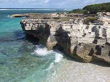
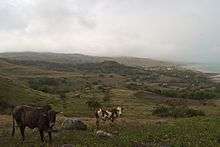
Rodrigues is a volcanic island rising from a ridge along the edge of the Mascarene Plateau. The tectonically active Rodrigues Triple Point lies on the sea-floor nearby. Rodrigues is only 1.5 million years old, even if the plateau under the lagoon surrounding Rodrigues may be much more ancient than the island.[11] Over time Rodrigues has developed a unique environment, including many endemic species.
Rodrigues is situated about 560 kilometres (350 mi) to the east of Mauritius. It is about 18 km (11 mi) long and 6.5 km (4.0 mi) wide with an area of 108 km2 (42 sq mi).[1][12] The shape is that of a whale back with a central ridge and deep cut valleys. The island is hilly with a central spine culminating in the highest peak, Mountain Limon at 398 m (1,306 ft). Rodrigues is the only Mascarene island with extensive limestone deposits and caves. A large fringing reef surrounds the island forming a lagoon within which lie eighteen small islets.[13][14]
The coral reef of Rodrigues is of particular interest as it is self-seeding – it receives no coral zooplankton from elsewhere. This has led to an overall species-poor but highly adapted ecosystem. A species of coral, two species of Pomacentrus damselfish and many species of crustaceans are found only on Rodrigues' reefs.[15]
Climate
The isolation and location of the island give a microclimate specific to Rodrigues, with two seasons. Rodrigues enjoys a mild tropical maritime climate with persistent trade winds blowing throughout the year. Mean summer temperature is 25.9 °C (78.6 °F) and mean winter temperature is around 22.3 °C (72.1 °F). The temperature difference between summer and winter is 3.6 °C. January to March are the hottest months and August is the coolest month. The wettest month is February; September and October are the driest months. The climate is hotter and drier than in Mauritius. Cyclones may arise from November to April, and Rodrigues is more often hit than Mauritius.[16]
| Climate data for Rodrigues | |||||||||||||
|---|---|---|---|---|---|---|---|---|---|---|---|---|---|
| Month | Jan | Feb | Mar | Apr | May | Jun | Jul | Aug | Sep | Oct | Nov | Dec | Year |
| Record high °C (°F) | 33.9 (93.0) |
34.0 (93.2) |
33.9 (93.0) |
33.0 (91.4) |
30.9 (87.6) |
30.9 (87.6) |
30.4 (86.7) |
31.2 (88.2) |
30.7 (87.3) |
30.9 (87.6) |
30.9 (87.6) |
33.1 (91.6) |
34.0 (93.2) |
| Average high °C (°F) | 29.2 (84.6) |
29.3 (84.7) |
29.4 (84.9) |
28.7 (83.7) |
27.5 (81.5) |
26.0 (78.8) |
25.0 (77.0) |
24.8 (76.6) |
25.4 (77.7) |
26.3 (79.3) |
27.4 (81.3) |
28.7 (83.7) |
27.3 (81.1) |
| Average low °C (°F) | 23.6 (74.5) |
23.8 (74.8) |
23.7 (74.7) |
23.0 (73.4) |
21.6 (70.9) |
20.1 (68.2) |
19.1 (66.4) |
18.8 (65.8) |
19.3 (66.7) |
20.1 (68.2) |
21.3 (70.3) |
22.8 (73.0) |
21.4 (70.5) |
| Record low °C (°F) | 18.4 (65.1) |
19.8 (67.6) |
19.0 (66.2) |
18.4 (65.1) |
18.1 (64.6) |
16.5 (61.7) |
14.5 (58.1) |
15.2 (59.4) |
15.8 (60.4) |
16.5 (61.7) |
17.2 (63.0) |
19.2 (66.6) |
14.5 (58.1) |
| Average precipitation mm (inches) | 150.0 (5.91) |
184.7 (7.27) |
131.2 (5.17) |
117.0 (4.61) |
78.3 (3.08) |
77.6 (3.06) |
80.8 (3.18) |
59.4 (2.34) |
43.8 (1.72) |
40.7 (1.60) |
70.0 (2.76) |
71.0 (2.80) |
1,104.5 (43.48) |
| Average precipitation days (≥ 1.0 mm) | 12 | 13 | 13 | 13 | 12 | 13 | 15 | 13 | 9 | 8 | 7 | 8 | 136 |
| Average relative humidity (%) | 79 | 81 | 80 | 79 | 75 | 74 | 75 | 74 | 74 | 74 | 76 | 77 | 76 |
| Mean monthly sunshine hours | 275.9 | 240.1 | 257.3 | 243.0 | 244.9 | 219.0 | 232.5 | 244.9 | 237.0 | 275.9 | 273.0 | 285.2 | 3,028.7 |
| Mean daily sunshine hours | 8.9 | 8.5 | 8.3 | 8.1 | 7.9 | 7.3 | 7.5 | 7.9 | 7.9 | 8.9 | 9.1 | 9.2 | 8.9 |
| Source: Mauritius Meteorological Services[16] | |||||||||||||
Biodiversity
Rodrigues was characterised by endemic plant and animal species in abundance, but since the seventeenth century much of its biodiversity has been eradicated. The island was home to a now extinct endemic species of flightless bird, the Rodrigues solitaire (Pezophaps solitaria). An endemic species of bat, the Rodrigues flying fox, is currently listed as endangered on the IUCN Red List. There are two remaining endemic bird species: the Rodrigues fody and the Rodrigues warbler, both are listed as near threatened.
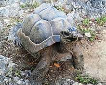
To restore some forest areas, Grande Montagne, Anse Quitor (with neighbouring François Leguat Giant Tortoise Reserve) and two islets, Île aux Sables and Île aux Cocos have been declared nature reserves (under the Forest and Reserves Act 1983).[17] Endangered plants on the reserves include Zanthoxylum paniculatum, Gastonia rodriguesiana, Badula balfouriana, and Gouania leguatii.[18][19]
Government and politics
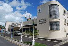
The island of Rodrigues is a constituency of the Republic of Mauritius and is dependent on the latter. However, on 20 November 2001, the Mauritius National Assembly unanimously adopted two laws giving Rodrigues its autonomy, creating a decentralised government system. This new legislation has allowed the implementation of a regional assembly in Rodrigues constituting 18 members and an executive council headed by a Chief Commissioner. The council meets every week to make decisions, draw up laws and manage the budget. The Chief Commissioner has the main task of informing the Mauritian Prime Minister of the management of the island's concerns. The last election of the Rodriguan Regional Assembly was held on 12 February 2017. The Organisation du Peuple de Rodrigues (OPR) party was the winner and obtained ten seats, while the Mouvement Rodriguais (MR) obtained seven. The current chief commissioner is Louis Serge Clair and the Chief Executive of Rodrigues is Davis Hee Hong Wye.
Electoral regions
The island includes six electoral regions: La Ferme (Region 1), Marechal (Region 2), Saint Gabriel (Region 3), Baie aux Huitres (Region 4), Port Mathurin (Region 5) and Grande Montagne (Region 6). Rodrigues Regional Assembly election are held every five years.
Zones
Rodrigues is divided into 14 municipalities or zones. For statistical purposes, the zones are further subdivided into a total of 182 localities. The zones have between a minimum of six localities (La Ferme) and maximum of 22 (the capital Port Mathurin).[20]
| Zone Nr. | Municipality | Population[note 1] |
|---|---|---|
| 05 Zone 5 | Port Mathurin | 5,929 |
| 08 Zone 8 | Lataniers-Mont Lubin | 3,806 |
| 09 Zone 9 | Petit Gabriel | 3,658 |
| 12 Zone 12 | Rivière Cocos | 2,893 |
| 10 Zone 10 | Mangues-Quatre Vents | 2,870 |
| 11 Zone 11 | Plaine Corail-La Fouche Corail | 2,832 |
| 13 Zone 13 | Port Sud-Est | 2,717 |
| 04 Zone 4 | Oyster Bay | 2,594 |
| 07 Zone 7 | Roche Bon Dieu-Trèfles | 2,059 |
| 14 Zone 14 | Coromandel-Graviers | 1,944 |
| 01 Zone 1 | Piments-Baie Topaze | 1,445 |
| 02 Zone 2 | La Ferme | 1,112 |
| 03 Zone 3 | Baie Malgache | 1,076 |
| 06 Zone 6 | Grand Baie-Montagne Goyaves | 844 |
| Rodrigues | 35,779 | |
Demographics
The population estimate (as of 24 December 2012) for the island of Rodrigues was 39,242.[4] The main religion is Christianity, dominated by Roman Catholicism with small minorities of other Christian branches like Jehovah's Witnesses, but also religions like Hindus, Muslims and Buddhists. Most of the inhabitants are of African descent and there is a minority of mixed-raced peoples, descendants of the first European settlers.
The main language is Rodriguan Creole, but English and French are most used as the languages of government administration, the courts and business.[5] Rodriguan Creole is very similar to Mauritian Creole, though some words are pronounced differently. People born in Rodrigues island are called Rodriguans.
Education
The education system in Rodrigues is similar to that throughout the rest of Mauritius. The government provides free education to students up to the tertiary level. Education is taught mainly in English.
Transportation
Rodrigues is served by the Sir Gaëtan Duval Airport in Point Corail.
Economy
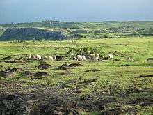
The economy of Rodrigues is mostly dependent on Mauritius. The main sources of income and economic activity are tourism, fishing, agriculture (especially of onions, garlic and chilli), and animal rearing. The handicraft industry has proven to be beneficial to the economy of the island. However, the income derived from the export of sea products, cattle, and food crops is smaller than the costs of imported products, creating a deficit. It has a special relationship with English-speaking countries, such as England in the United Kingdom, Australia and Ireland.[21]
Culture
Music and folklore
The traditional music of the island is known as Sega Tambour. The music has an accentuated beat, usually accompanied by an accordion, clapping and the use of improvised percussion instruments like bamboo. The folk dance music is similar to polkas, quadrilles, waltzes and Scottish reels.
Cuisine
Rodrigues cuisine consists of dishes from local products: fruit, vegetables, seafood (fish, octopus, crab, shrimp, lobster) and meat. National dishes include sausages with kreolinės, rougaille sauce, octopus with curry, Azim salad and Rodrigues cake.
Sports
The most common sport in Rodrigues is association football. There are local competitions almost throughout the year and in specific competitions, the winning team travels to Mauritius for sport exchange. Volleyball is also popular. There is also a public swimming pool at Marechal, a village located in the center of the island, and a stadium at Camp Du Rois in the region of Port Mathurin.
Notes
- Census of 2000
- In parliament English is official and French can be used.
References
- "Geography − location". Government of Mauritius. Retrieved 10 March 2012.
- Ministry of Finance & Economic Development (1 July 2014). "Population and Vital Statistics Jan-June 2014" (PDF). Government of Mauritius: n/a. Retrieved 1 July 2014. Cite journal requires
|journal=(help) - "Article 49 of The Constitution". National Assembly of Mauritius. Archived from the original on 23 December 2014. Retrieved 1 November 2011.
- Ministry of Finance & Economic Development (2012). "ANNUAL DIGEST OF STATISTICS 2012" (PDF). 31 December. Government of Mauritius: 19. Retrieved 20 October 2013. Cite journal requires
|journal=(help) - "General Information about Rodrigues". Government of Mauritius. Retrieved 10 March 2012.
- "The Arabs". Encyclopædia Mauritiana. Archived from the original on 1 May 2012. Retrieved 6 March 2014.
- "Mauritius". www.worldstatesmen.org. Retrieved 8 December 2018.
- Joslin, Litherland and Simpkin. British Battles and Medals. p. 30. Published Spink, London. 1988.ISBN 0907605257
- "How Krakatoa made the biggest bang — Science — News". The Independent. 3 May 2006. Retrieved 6 March 2014.
- "Admiral Nevelskoi - ShipSpotting.com - Ship Photos and Ship Tracker". www.shipspotting.com. Retrieved 8 December 2018.
- "Geography − Overview". Government of Mauritius. Retrieved 10 March 2012.
- "Meteorological Services − Monthly Bulletin of Climatological Summaries" (PDF). May 2008. Mauritius Meteorological Services. p. 3. Archived from the original (PDF) on 10 October 2013. Retrieved 22 March 2012.
- "Overview of the Biodiversity of Rodrigues" (PDF). Government of Mauritius. Retrieved 10 March 2012.
- "Hydrology of Rodrigues and Agalega" (PDF). Government of Mauritius. Retrieved 10 March 2012.
- "Convention on Biological Diversity – Third National Report for the Republic of Mauritius, Section 5.2.1, p. 26" (PDF). Ministry of Environment and National Development Unit in collaboration with the UNEP/GEF. October 2006. Retrieved 19 January 2007.
- "Climate of Rodrigues & other outer islands". Mauritius Meteorological Services. Retrieved 26 January 2015.
- Ministry of Environment and Sustainable Development. "Fourth National Report on the Convention on Biological Diversity – Republic of Mauritius" (PDF). August 2010. Convention on Biological Diversity. Retrieved 10 March 2012.
- "Welcome to the Mauritian Wildlife Foundation (MWF) - In The Field - Rodrigues - Anse Quitor". www.mauritian-wildlife.org. Retrieved 8 December 2018.
- "Welcome to the Mauritian Wildlife Foundation (MWF) - In The Field - Rodrigues - Plant". www.mauritian-wildlife.org. Retrieved 8 December 2018.
- "List of localities within each zone defined for Rodrigues". Government of Mauritius. Retrieved 10 March 2012. Cite journal requires
|journal=(help) - "Mauritius : Economy - The Commonwealth". thecommonwealth.org. Retrieved 8 December 2018.
External links
Outer islands of Mauritius | |||||
|---|---|---|---|---|---|
| Outer islands | .svg.png) | ||||
| Islets |
| ||||
| Fishing banks | |||||
| |||||
| Subdivisions |
| | ||||||||||||
|---|---|---|---|---|---|---|---|---|---|---|---|---|---|---|
| Politics |
| |||||||||||||
| Economy | ||||||||||||||
| Society |
| |||||||||||||