Rich Township, Cook County, Illinois
Rich Township is one of 29 townships in Cook County, Illinois, USA. As of the 2010 census, its population was 76,727.[2]
Rich Township | |
|---|---|
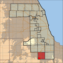 Location in Cook County | |
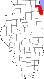 Cook County's location in Illinois | |
| Coordinates: 41°30′45″N 87°43′56″W | |
| Country | United States |
| State | Illinois |
| County | Cook |
| Area | |
| • Total | 36.59 sq mi (94.78 km2) |
| • Land | 36.36 sq mi (94.17 km2) |
| • Water | 0.24 sq mi (0.61 km2) 0.64% |
| Elevation | 709 ft (216 m) |
| Population (2010) | |
| • Estimate (2016)[1] | 76,470 |
| • Density | 2,110/sq mi (814.8/km2) |
| Time zone | UTC-6 (CST) |
| • Summer (DST) | UTC-5 (CDT) |
| ZIP codes | 60422, 60423, 60429, 60430, 60443, 60461, 60466, 60471, 60477, 60478 |
| FIPS code | 17-031-63498 |
| Website | www |
Geography
According to the United States Census Bureau, Rich Township covers an area of 36.59 square miles (94.8 km2); of this, 36.36 square miles (94.2 km2) (99.36 percent) is land and 0.24 square miles (0.62 km2) (0.64 percent) is water.
Cities, towns, villages
- Country Club Hills (south half)
- Flossmoor (west three-quarters)
- Frankfort (small portion)
- Hazel Crest (small portion)
- Homewood (small portion)
- Matteson (vast majority)
- Olympia Fields (vast majority)
- Park Forest (north three-quarters)
- Richton Park
- Tinley Park (small portion)
- University Park (small portion)
Adjacent townships
- Bremen Township (north)
- Thornton Township (northeast)
- Bloom Township (east)
- Monee Township, Will County (south)
- Green Garden Township, Will County (southwest)
- Frankfort Township, Will County (west)
- Orland Township (northwest)
Cemeteries
The township contains these eight cemeteries: Coopers Grove, Elliott Family, Lutheran, New German Evangelical Zion, Saint Anne, Saint Pauls Evangelical Lutheran, Saint Pauls Evangelical Reform and Zion Evangelical Lutheran.
Major highways
Airports and landing strips
- Olympia Fields Osteopathic Medical Center Heliport
- Prosperi Airport (historical)
Landmarks
- Augustinian Seminary
- South Green Belt Forest Preserve (vast majority)
Political districts
- Illinois' 1st congressional district
- State House District 37
- State House District 38
- State House District 80
- State Senate District 19
- State Senate District 40
Education
Rich Township High School District 227 serves high school students.
References
- "Rich Township, Cook County, Illinois". Geographic Names Information System. United States Geological Survey. Retrieved 2010-01-10.
- United States Census Bureau 2007 TIGER/Line Shapefiles
- United States National Atlas
- "Population and Housing Unit Estimates". Retrieved June 9, 2017.
- "Geographic Identifiers: 2010 Demographic Profile Data (DP-1): Rich township, Cook County, Illinois". U.S. Census Bureau, American Factfinder. Archived from the original on February 12, 2020. Retrieved March 21, 2013.
- "Census of Population and Housing". Census.gov. Retrieved June 4, 2016.
External links
- Rich Township official website
- City-Data.com
- Illinois State Archives
- Township Officials of Illinois
- Cook County official site
This article is issued from Wikipedia. The text is licensed under Creative Commons - Attribution - Sharealike. Additional terms may apply for the media files.