Proctor, Oklahoma
Proctor is a census-designated place (CDP) in Adair County, Oklahoma, United States. The population was 231 at the 2010 census.[3]
Proctor, Oklahoma | |
|---|---|
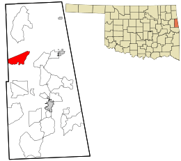 Location within Adair County and the state of Oklahoma | |
| Coordinates: 35°57′58″N 94°46′38″W | |
| Country | United States |
| State | Oklahoma |
| County | Adair |
| Area | |
| • Total | 8.5 sq mi (21.9 km2) |
| • Land | 8.4 sq mi (21.8 km2) |
| • Water | 0.08 sq mi (0.2 km2) |
| Elevation | 820 ft (250 m) |
| Population (2010) | |
| • Total | 231 |
| • Density | 27/sq mi (10.6/km2) |
| Time zone | UTC-6 (Central (CST)) |
| • Summer (DST) | UTC-5 (CDT) |
| Zip code | 74457 |
| FIPS code | 40-60750[1] |
| GNIS feature ID | 2584390[2] |
Geography
Proctor is located at 35°57′58″N 94°46′39″W, in the valley of the Baron Fork, a tributary of the Illinois River of Oklahoma, part of the Arkansas River watershed. U.S. Route 62 runs through the center of the community, leading east 13 miles (21 km) to Westville and west 14 miles (23 km) to Tahlequah.
According to the United States Census Bureau, the CDP has a total area of 8.5 square miles (21.9 km2), of which 8.4 square miles (21.8 km2) is land and 0.077 square miles (0.2 km2), or 0.77%, is water.[3]
References
- "U.S. Census website". United States Census Bureau. Retrieved 2008-01-31.
- "US Board on Geographic Names". United States Geological Survey. 2007-10-25. Retrieved 2008-01-31.
- "Geographic Identifiers: 2010 Demographic Profile Data (G001): Proctor CDP, Oklahoma". U.S. Census Bureau, American Factfinder. Archived from the original on February 12, 2020. Retrieved July 12, 2013.
Municipalities and communities of Adair County, Oklahoma, United States | ||
|---|---|---|
| City | 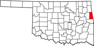 Adair County map | |
| Towns | ||
| CDPs | ||
| Other unincorporated communities | ||
| Indian reservation | ||
| Footnotes | ‡This populated place also has portions in an adjacent county or counties | |
This article is issued from Wikipedia. The text is licensed under Creative Commons - Attribution - Sharealike. Additional terms may apply for the media files.