Mulberry, Oklahoma
Mulberry is a census-designated place (CDP) in Adair County, Oklahoma, United States. The population was 138 at the 2010 census.[3]
Mulberry, Oklahoma | |
|---|---|
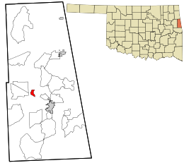 Location within Adair County and the state of Oklahoma | |
| Coordinates: 35°51′45″N 94°42′0″W | |
| Country | United States |
| State | Oklahoma |
| County | Adair |
| Area | |
| • Total | 0.9 sq mi (2.4 km2) |
| • Land | 0.9 sq mi (2.4 km2) |
| • Water | 0.0 sq mi (0.0 km2) |
| Elevation | 1,000 ft (300 m) |
| Population (2010) | |
| • Total | 138 |
| • Density | 148/sq mi (57.0/km2) |
| Time zone | UTC-6 (Central (CST)) |
| • Summer (DST) | UTC-5 (CDT) |
| FIPS code | 40-49825[1] |
| GNIS feature ID | 2584385[2] |
Geography
Mulberry is located at 35°51′45″N 94°42′0″W, along Oklahoma State Highway 51. It is 6 miles (10 km) northwest of Stilwell, the county seat, and 18 miles (29 km) east of Tahlequah in Cherokee County.
According to the United States Census Bureau, the CDP has a total area of 0.93 square miles (2.4 km2).[3]
References
- "U.S. Census website". United States Census Bureau. Retrieved 2008-01-31.
- "US Board on Geographic Names". United States Geological Survey. 2007-10-25. Retrieved 2008-01-31.
- "Geographic Identifiers: 2010 Demographic Profile Data (G001): Mulberry CDP, Oklahoma". U.S. Census Bureau, American Factfinder. Archived from the original on February 12, 2020. Retrieved July 12, 2013.
Municipalities and communities of Adair County, Oklahoma, United States | ||
|---|---|---|
| City | 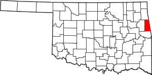 Adair County map | |
| Towns | ||
| CDPs | ||
| Other unincorporated communities | ||
| Indian reservation | ||
| Footnotes | ‡This populated place also has portions in an adjacent county or counties | |
This article is issued from Wikipedia. The text is licensed under Creative Commons - Attribution - Sharealike. Additional terms may apply for the media files.