Pacific Grove, California
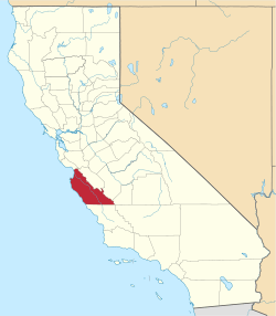
Pacific Grove is a coastal city in Monterey County, California in the United States. The 2010 United States Census population is 15,041. Pacific Grove is located between Point Pinos and Monterey.[1]
City of Pacific Grove | |
|---|---|
City in California | |
.jpg) Point Pinos Lighthouse, the oldest continuously operating lighthouse on the West Coast (1855). | |
 Seal | |
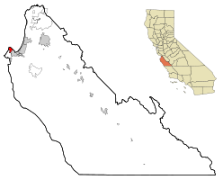 Location in Monterey County and the state of California | |
 City of Pacific Grove Location in the United States | |
| Coordinates: 36°37′04″N 121°55′00″W | |
| Country | United States |
| State | California |
| County | Monterey |
| Founded | 1875[1] |
| Incorporated | July 5, 1889[2] |
| Government | |
| • Type | Mayor–council |
| • Mayor | Bill Peake[3] |
| • State Senator | Bill Monning (D)[4] |
| • Assemblymember | Mark Stone (D)[4] |
| • U. S. Rep. | Jimmy Panetta (D)[5] |
| Area | |
| • Total | 4.00 sq mi (10.36 km2) |
| • Land | 2.87 sq mi (7.43 km2) |
| • Water | 1.13 sq mi (2.93 km2) 28.42% |
| Elevation | 151 ft (46 m) |
| Population | |
| • Total | 15,041 |
| • Estimate (2019)[9] | 15,413 |
| • Density | 5,370.38/sq mi (2,073.79/km2) |
| Time zone | UTC-8 (PST) |
| • Summer (DST) | UTC-7 (PDT) |
| ZIP code | 93950 |
| Area code(s) | 831 |
| FIPS code | 06-54848 |
| GNIS feature IDs | 1652821, 2411350 |
| Website | www |
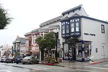
Pacific Grove has numerous Victorian-era houses, some of which have been turned into bed and breakfast inns. The city is also the location of the Point Pinos Lighthouse, the Pacific Grove Museum of Natural History and the Pacific Grove Art Center. Author John Steinbeck resided in Pacific Grove for a number of years. Later, the area was a filming location for A Summer Place starring Sandra Dee, for Roger Spottiswoode's 1989 film Turner & Hooch, and for the TV series Big Little Lies.
History
Pacific Grove was founded in 1875 when the Pacific Land Improvement Company, owned by David Jacks, donated acreage towards the first West Coast Chautauqua retreat formed by a group of Methodists who modeled the town after Ocean Grove, New Jersey.[1] In time, the butterflies, fragrant pines and fresh sea air brought others to the Pacific Grove Retreat to rest and meditate. The initial camp meeting of the Pacific Coast branch of the Chautauqua Literary and Scientific Circle was held in Pacific Grove in June 1879. Modeled after the Methodist Sunday school teachers' training camp established in 1874 at Chautauqua Lake, New York, this location became part of a nationwide educational network.

In November 1879, after the summer campers returned home, Robert Louis Stevenson wandered into the deserted campgrounds: "I have never been in any place so dreamlike. Indeed, it was not so much like a deserted town as like a scene upon the stage by daylight, and with no one on the boards."
The Pacific Grove post office opened in 1886, closed later that year, and was re-opened in 1887.[1] Pacific Grove incorporated in 1889.[1]
Pacific Grove, like Carmel-by-the-Sea and Monterey, became an artists' haven in the 1890s and subsequent period. Artists of the En plein air school in both Europe and the United States were seeking an outdoor venue which had natural beauty, so that Pacific Grove was a magnet for this movement. William Adam was an English painter who first moved to Monterey and then decided on Pacific Grove for his home in 1906. At about the same time Eugen Neuhaus, a German painter, arrived in Pacific Grove with his new bride. Charles B. Judson was an artist of aristocratic lineage who painted in Pacific Grove over a long period of time beginning in 1907; Judson's murals decorate the halls of the California Academy of Sciences.
The Asilomar Conference Grounds are located at the western edge of Pacific Grove. Asilomar opened in 1913 as a YWCA summer retreat it now belongs to the California State Park System. Thirteen buildings on these grounds were designed by the architect Julia Morgan, who also designed Hearst Castle.
For a number of years, John Steinbeck lived in a cottage in Pacific Grove owned by his father, Ernest, who was Monterey County treasurer. The cottage still stands on a quiet side street at 147 11th St., without any plaque or special sign, virtually overlooked by most Steinbeck fans. Another Steinbeck related house is at 222 Central Ave, which was his grandmother's house. A golden statue of Steinbeck in the front yard stood for years before it was removed.[10] In Steinbeck's book Sweet Thursday, a chapter is dedicated to describing a (probably fictional) rivalry that arose among the town's residents over the game of roque.
Local traditions include a Butterfly Parade held in early October to celebrate the return of the monarch butterfly to its wintering habitat. Also held in July is the Feast of Lanterns, a unique faux Chinese festival whose origin is rooted in the traditional Chautauqua closing ceremonies from the late 1800s. Feast of Lanterns is a weeklong festival with opening ceremonies held at Chautauqua Hall, a pet parade and a Chinese style pageant with fireworks at Lover's Point Beach on the last Saturday in July. Mid April a Good Old Days festival is held downtown which includes rides, crafts booths, food, entertainment and parade.
Hopkins Marine Station, maintains a campus next to the Monterey Bay Aquarium. Hopkins Marine Station was founded in 1892, making it the oldest marine laboratory on the US Pacific Coast, and the second-oldest in the US, after the Marine Biological Laboratory in Woods Hole, Massachusetts. It was originally named the Hopkins Seaside Laboratory and located on what is now Lover's Point.
In the 1980s, Pacific Grove was the site of the pioneering microcomputer software company Digital Research. Originally located in Gary Kildall's house on the corner of Lighthouse and Willow it later moved to offices on Central Ave.
On October 12, 1997, John Denver died when he crashed into the Pacific Ocean off Pacific Grove in his personal plane.[11]
Pacific Grove was the last dry town in California. Due to its religious and gated history alcohol was not served to the public until July 4, 1969, at the grand opening of the Pacific Grove Art Center by ElMarie Dyke, its founder. This caused much controversy because the law wasn't to take effect until November of that year. Ironically, ElMarie was also a great proponent for keeping the town dry. To this day Pacific Grove has very strict laws regarding the service of alcohol and there are no stand-alone bars. (Alton Pryor, November 15, 2005, California's Last Dry Town).
At the November 6, 2018 general municipal election Pacific Grove voters approved Measure M, which prohibits short-term vacation rentals in residential districts outside the Coastal Zone.[12]
Environmental features and geography
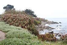
Pacific Grove contains several habitat types including marine, littoral, pine forest and mixed oak woodland. The famed breeding habitat for the monarch butterfly is situated in the northwest part of town imbedded in residential neighborhoods in mixed oak forests. These monarchs migrate 2,000 miles (3,200 km) to reach Pacific Grove after their summer in the Rocky Mountains, often soaring as high as 3,000 meters (9,800 ft).
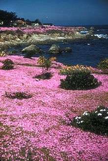
The black-and-orange monarch butterflies spend much of the fall and winter in Monterey pine and eucalyptus trees, roughly from the vernal equinox through the spring equinox.[13] The majority of butterflies are protected in the city's Butterfly Sanctuary. City Ordinance No. 352 makes it a misdemeanor to kill or threaten a butterfly, punishable by a $1000 fine.
Pacific Grove Marine Gardens State Marine Conservation Area, Lovers Point State Marine Reserve, Edward F. Ricketts State Marine Conservation Area and Asilomar State Marine Reserve are marine protected areas in the waters around Pacific Grove. Like underwater parks, these marine protected areas help conserve ocean wildlife and marine ecosystems. Monterey Bay is a marine protected sanctuary.
The principal noise source in Pacific Grove is State Route 68. There are approximately 800 residents exposed to sound levels of 60 CNEL or above, making Pacific Grove noticeably quieter than its neighbor Monterey, which has more tourist traffic and more through traffic.[14]
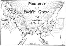
The town sits between its two well known neighbors, Pebble Beach and Monterey. Carmel-by-the-Sea is the next city, five miles to the south, and the community of Big Sur is 30 miles south. Pacific Grove is a favorite vacation getaway for San Francisco Bay Area residents, located one and a half hours south of San Francisco.
The town does not allow development on the waterside of the ocean-front street, so that the beaches and scenic points are unobstructed.

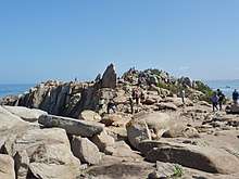
Pacific Grove is located at 36°37′9″N 121°55′16″W (36.619065, -121.921025).[15] That places it on the Pacific Ocean between Monterey and Pebble Beach, about 40 miles south of Santa Cruz and about 100 miles south of San Francisco. According to the United States Census Bureau, the city has a total area of 4.0 square miles (10 km2). 2.9 square miles (7.5 km2) of it is land and 1.1 square miles (2.8 km2) of it (28.42%) is water. Asilomar, Lovers Point and the intervening coastline afford surfing, which is challenging due to near shore rocks, albeit waves are typically moderate in height.
Pacific Grove's climate is mild throughout the year, essentially the same as in neighboring Monterey, with most of the rain falling from November through April. Extreme temperatures are rare and fog is common, especially in the late night and early morning, all year. (See Monterey for more details.)
Climate
This region experiences warm (but not hot) and dry summers, with no average monthly temperatures above 71.6 °F. According to the Köppen Climate Classification system, Pacific Grove has a warm-summer Mediterranean climate, abbreviated "Csb" on climate maps.[16]
Government
Pacific Grove is governed by city council consisting of a mayor and six councilmembers, all elected at-large. As of the November 2018 election the mayor is Bill Peake, and Robert Huitt serves as mayor pro tempore. The remaining councilmembers are Jenny McAdams, Amy Tomlinson, Joe Amelio, Cynthia Garfield, and Nick Smith.[17]
At the county level, Pacific Grove is represented on the Monterey County Board of Supervisors by Mary Adams.[18]
In the California State Assembly, Pacific Grove is represented by Mark Stone as part of the 29th Assembly district. In the California State Senate, it is represented by Bill Monning as part of the 17th Senate district.[4]
In the United States House of Representatives, Pacific Grove is in California's 20th congressional district, represented by Democrat Jimmy Panetta[5]
Demographics
| Historical population | |||
|---|---|---|---|
| Census | Pop. | %± | |
| 1890 | 1,336 | — | |
| 1900 | 1,411 | 5.6% | |
| 1910 | 2,384 | 69.0% | |
| 1920 | 2,974 | 24.7% | |
| 1930 | 5,558 | 86.9% | |
| 1940 | 6,249 | 12.4% | |
| 1950 | 9,623 | 54.0% | |
| 1960 | 12,121 | 26.0% | |
| 1970 | 13,505 | 11.4% | |
| 1980 | 15,755 | 16.7% | |
| 1990 | 16,117 | 2.3% | |
| 2000 | 15,522 | −3.7% | |
| 2010 | 15,041 | −3.1% | |
| Est. 2019 | 15,413 | [9] | 2.5% |
| U.S. Decennial Census[19] | |||
2010
The 2010 United States Census[20] reported that Pacific Grove had a population of 15,041. The population density was 3,758.1 people per square mile (1,451.0/km2). The racial makeup of Pacific Grove was 12,710 (84.5%) White, 199 (1.3%) African American, 78 (0.5%) Native American, 872 (5.8%) Asian, 49 (0.3%) Pacific Islander, 469 (3.1%) from other races, and 664 (4.4%) from two or more races. Hispanic or Latino of any race were 1,615 persons (10.7%).
The Census reported that 14,686 people (97.6% of the population) lived in households, 140 (0.9%) lived in non-institutionalized group quarters, and 215 (1.4%) were institutionalized.
There were 7,020 households, out of which 1,526 (21.7%) had children under the age of 18 living in them, 2,934 (41.8%) were opposite-sex married couples living together, 653 (9.3%) had a female householder with no husband present, 233 (3.3%) had a male householder with no wife present. There were 349 (5.0%) unmarried opposite-sex partnerships, and 58 (0.8%) same-sex married couples or partnerships. 2,609 households (37.2%) were made up of individuals, and 1,012 (14.4%) had someone living alone who was 65 years of age or older. The average household size was 2.09. There were 3,820 families (54.4% of all households); the average family size was 2.74.
The population was spread out, with 2,479 people (16.5%) under the age of 18, 988 people (6.6%) aged 18 to 24, 3,466 people (23.0%) aged 25 to 44, 4,864 people (32.3%) aged 45 to 64, and 3,244 people (21.6%) who were 65 years of age or older. The median age was 48.1 years. For every 100 females, there were 85.2 males. For every 100 females age 18 and over, there were 81.1 males.
There were 8,169 housing units at an average density of 2,041.1 per square mile (788.1/km2), of which 3,205 (45.7%) were owner-occupied, and 3,815 (54.3%) were occupied by renters. The homeowner vacancy rate was 3.8%; the rental vacancy rate was 4.4%. 7,071 people (47.0% of the population) lived in owner-occupied housing units and 7,615 people (50.6%) lived in rental housing units.
There are over 1300 structures listed on the town's historic register giving Pacific Grove the largest inventory of historic homes and structures for its size on the West Coast.
2000
As of the census[21] of 2000, there were 15,522 people, 7,316 households, and 3,972 families residing in the city. The population density was 5,399.2 people per square mile (2,088.2/km2). There were 8,032 housing units at an average density of 2,793.9 per square mile (1,080.5/km2). The racial makeup of the city was 88.04% White, 1.14% African American, 0.55% Native American, 4.50% Asian, 0.26% Pacific Islander, 1.78% from other races, and 3.73% from two or more races. 7.14% of the population were Hispanic.
There were 7,316 households, out of which 21.6% had children under the age of 18 living with them, 41.7% were married couples living together, 9.6% had a female householder with no husband present, and 45.7% were non-families. 36.8% of all households were made up of individuals, and 14.2% had someone living alone who was 65 years of age or older. The average household size was 2.10 and the average family size was 2.75. The age distribution is: 17.8% under the age of 18, 5.7% from 18 to 24, 27.0% from 25 to 44, 29.9% from 45 to 64, and 19.6% who were 65 years of age or older. The median age was 45 years. For every 100 females, there were 85.8 males. For every 100 females age 18 and over, there were 81.5 males.
The median income for a household in the city was $50,254, and the median income for a family was $59,569. Males had a median income of $43,897 versus $35,924 for females. The per capita income for the city was $31,277. About 3.0% of families and 5.4% of the population were below the poverty line, including 4.6% of those under age 18 and 3.9% of those age 65 or over.
Notable residents
- Mark Bingham one of the four Americans who downed flight 93 on 9/11 over Shanksville, Pennsylvania
- Sam Bottoms, actor
- Ernest K. Bramblett, politician
- Eleanor Cameron, author
- Joseph Campbell, mythologist
- Mimi Farina, singer, songwriter
- Peter S. Fischer, writer and producer
- Paul Fleischman, author
- Julie Heffernan, artist
- Ben Jealous, NAACP president (2008–2013)
- Janis Joplin, singer
- Slim Keith, socialite and fashion icon
- Gary Kildall, scientist and founder of Digital Research
- Peter Koper, writer and producer
- Johnny Miller, professional golfer
- Ward Moore, science fiction writer
- Maxine Nightingale, singer
- Greg Norman, golfer
- Julia Platt, mayor
- Arthur Porges, science fiction writer
- Gina Prince-Bythewood, film director and writer
- Josh Randall, actor
- Clark Ashton Smith, poet, fantasy fiction writer
- John Steinbeck, author
- Ken Swofford, actor
- Bill Walsh, football coach
- Mare Winningham, actor
- Laurence Yep, children's book author
- Frank Zappa, musician, songwriter
Media
- See also: Media in Monterey County, California
Local radio station KAZU-FM - 90.3 was created by Don Mussel in 1977 in Pacific Grove but is now located in Seaside, California. Television service for the community comes from the Monterey-Salinas-Santa Cruz designated market area (DMA). Local newspapers include the Cedar Street Times and The Monterey County Herald.
See also
- Coastal California
- Feast of Lanterns
- List of school districts in Monterey County, California
- Monterey county attractions
- Pacific Grove High School
References
- Durham, David L. (1998). California's Geographic Names: A Gazetteer of Historic and Modern Names of the State. Clovis, Calif.: Word Dancer Press. p. 932. ISBN 1-884995-14-4.
- "California Cities by Incorporation Date". California Association of Local Agency Formation Commissions. Archived from the original (Word) on October 17, 2013. Retrieved August 25, 2014.
- "Mayor & Council". City of Pacific Grove. Retrieved December 8, 2018.
- "Statewide Database". UC Regents. Archived from the original on February 1, 2015. Retrieved December 30, 2014.
- "California's 20th Congressional District - Representatives & District Map". Civic Impulse, LLC. Retrieved September 24, 2014.
- "2019 U.S. Gazetteer Files". United States Census Bureau. Retrieved July 1, 2020.
- "Pacific Grove". Geographic Names Information System. United States Geological Survey. Retrieved April 18, 2015.
- "Pacific Grove (city) QuickFacts". United States Census Bureau. Archived from the original on January 8, 2015. Retrieved January 7, 2015.
- "Population and Housing Unit Estimates". United States Census Bureau. May 24, 2020. Retrieved May 27, 2020.
- Howe, Kevin (April 14, 2011). "Pacific Grove cottage where Steinbeck's grandmother lived being restored". The Monterey Herald.
- "Closeup: The John Denver Crash". Archived from the original on March 9, 2017. Retrieved March 20, 2019.CS1 maint: BOT: original-url status unknown (link)
- "Pacific Grove, California, Measure M, Limitations on Short-Term Rentals (November 2018)". Ballotpedia. Retrieved November 30, 2018.
- Mayberry, Carly (August 25, 2016). "P.G. monarch sanctuary hopes to benefit from butterfly conservation funds". Monterey Herald. Retrieved August 28, 2016.
- (Hogan, 1980).
- "US Gazetteer files: 2010, 2000, and 1990". United States Census Bureau. February 12, 2011. Retrieved April 23, 2011.
- Climate Summary for Pacific Grove, California
- "Elected Officials". City of Pacific Grove. Archived from the original on February 2, 2015. Retrieved January 30, 2015.
- "Monterey County Supervisorial District 5 Map (North District 5)" (PDF). County of Monterey. Archived from the original (PDF) on July 1, 2012. Retrieved September 21, 2012.
- "Census of Population and Housing". Census.gov. Retrieved June 4, 2015.
- "2010 Census Interactive Population Search: CA - Pacific Grove city". U.S. Census Bureau. Archived from the original on July 15, 2014. Retrieved July 12, 2014.
- "U.S. Census website". United States Census Bureau. Retrieved January 31, 2008.
External links
| Wikimedia Commons has media related to Pacific Grove, California. |
| Wikivoyage has a travel guide for Pacific Grove. |
- Official website: https://cityofpacificgrove.org
| Authority control |
|
|---|