Orinda, California
Orinda is a city in Contra Costa County, California, United States. The population was 17,643 at the 2010 census, and was estimated in 2019 to have increased to 19,926.[8] In 2012, Orinda was ranked the second most friendly town in America by Forbes.[9] The city is located just east of the city of Berkeley and is home to many affluent suburban professionals who commute to larger cities in the Bay Area such as Oakland, San Francisco, and Walnut Creek. Its location provides for a more rustic landscape, and Orinda's many parks and trails make it a destination for many Bay Area hikers and naturalists.
City of Orinda | |
|---|---|
City | |
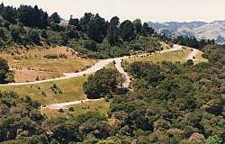 The hills of Orinda | |
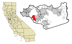 Location in Contra Costa County and the state of California | |
 City of Orinda Location in the United States | |
| Coordinates: 37°52′58″N 122°10′47″W | |
| Country | United States |
| State | California |
| County | Contra Costa |
| Incorporated | July 1, 1985[1] |
| Government | |
| • Mayor | Inga Miller[2] |
| • State Senator | Steve Glazer (D)[3] |
| • State Assembly | Rebecca Bauer-Kahan (D)[4] |
| • U. S. Congress | Mark DeSaulnier (D)[5] |
| Area | |
| • Total | 12.87 sq mi (33.33 km2) |
| • Land | 12.85 sq mi (33.29 km2) |
| • Water | 0.02 sq mi (0.04 km2) 0.12% |
| Elevation | 495 ft (151 m) |
| Population (2010) | |
| • Total | 17,643 |
| • Estimate (2019)[7] | 19,926 |
| • Density | 1,550.42/sq mi (598.64/km2) |
| Time zone | UTC−8 (PST) |
| • Summer (DST) | UTC−7 (PDT) |
| ZIP Code | 94563 |
| Area code(s) | 925 |
| FIPS code | 06-54232 |
| GNIS feature IDs | 1659313, 2411334 |
| Website | www |
History
Orinda is located within four Mexican land grants: Rancho Laguna de los Palos Colorados, Rancho Acalanes, Rancho El Sobrante and Rancho Boca de la Cañada del Pinole. The area was originally rural, mainly known for ranching and summer cabins. In the late-19th century, the land was named by Alice Marsh Cameron, probably in honor of the poet Katherine Philips, who was also known as the "Matchless Orinda".[10]
In the 1880s, the United States Surveyor General for California, Theodore Wagner, built an estate which he named Orinda Park.[11] The Orinda Park post office opened in 1888.[11] The post office's name was changed to Orinda in 1895.[11] Orinda was also the site of Bryant Station, a stop on the failed California and Nevada Railroad around the turn of the 20th century. In later times, the area around Bryant Station was known as Orinda Crossroads.[11]
Orinda's popularity as a year-round residence grew after the 1937 completion of the Caldecott Tunnel, which provided easier access to the west. Bisected by California State Route 24 and framed by its rolling oak-covered hills, the city of Orinda was incorporated on July 1, 1985. Its first mayor was Richard G. Heggie. The city has a station on the Antioch–SFO/Millbrae line of the Bay Area Rapid Transit.
Geography
According to the United States Census Bureau, the city has a total area of 12.7 sq mi (33 km2), of which 12.7 sq mi (33 km2) of it is land and 0.015 sq mi (0.039 km2) of it (0.12%) is water.
Climate
The area is characterized by a warm-summer Mediterranean climate (Köppen climate classification Csb) with cool, rainy winters and warm, dry summers. Because Orinda is located in a hilly area, microclimates often dominate temperature differences in short distances. The Oakland Hills often block the cool foggy conditions that can be seen in Oakland and the innerbay. In the summer, fog can spill over the Oakland hills, cooling off the area. Heatwaves from the inland areas can be felt much more in Orinda than in Oakland and the innerbay during the summer. In the winter, Orinda often sees more precipitation than surrounding areas because of its higher elevation. Snowfall is rare but not unheard of. A dusting of snow may occur in any given year because of the elevation. During stable conditions in the winter, mornings can be cold and frosty in downtown and lower-lying areas, while the higher hills surrounding the area may be several degrees warmer.
| Orinda, California | ||||||||||||||||||||||||||||||||||||||||||||||||||||||||||||
|---|---|---|---|---|---|---|---|---|---|---|---|---|---|---|---|---|---|---|---|---|---|---|---|---|---|---|---|---|---|---|---|---|---|---|---|---|---|---|---|---|---|---|---|---|---|---|---|---|---|---|---|---|---|---|---|---|---|---|---|---|
| Climate chart (explanation) | ||||||||||||||||||||||||||||||||||||||||||||||||||||||||||||
| ||||||||||||||||||||||||||||||||||||||||||||||||||||||||||||
| ||||||||||||||||||||||||||||||||||||||||||||||||||||||||||||
| Climate data for Orinda Bowman, California (1944–1960) | |||||||||||||
|---|---|---|---|---|---|---|---|---|---|---|---|---|---|
| Month | Jan | Feb | Mar | Apr | May | Jun | Jul | Aug | Sep | Oct | Nov | Dec | Year |
| Record high °F (°C) | 69 (21) |
76 (24) |
84 (29) |
88 (31) |
100 (38) |
103 (39) |
107 (42) |
109 (43) |
110 (43) |
101 (38) |
87 (31) |
77 (25) |
110 (43) |
| Average high °F (°C) | 54 (12) |
59 (15) |
61 (16) |
68 (20) |
71 (22) |
77 (25) |
82 (28) |
81 (27) |
83 (28) |
75 (24) |
65 (18) |
56 (13) |
69 (21) |
| Average low °F (°C) | 34 (1) |
37 (3) |
38 (3) |
42 (6) |
46 (8) |
49 (9) |
52 (11) |
51 (11) |
50 (10) |
44 (7) |
38 (3) |
36 (2) |
43 (6) |
| Record low °F (°C) | 15 (−9) |
18 (−8) |
23 (−5) |
28 (−2) |
32 (0) |
35 (2) |
42 (6) |
40 (4) |
32 (0) |
26 (−3) |
22 (−6) |
19 (−7) |
15 (−9) |
| Average precipitation inches (mm) | 5.99 (152) |
4.86 (123) |
4.31 (109) |
2.16 (55) |
1.22 (31) |
0.18 (4.6) |
0.02 (0.51) |
0.05 (1.3) |
0.41 (10) |
1.85 (47) |
3.24 (82) |
6.24 (158) |
30.53 (773.41) |
| Average rainy days | 11 | 9 | 10 | 5 | 4 | 1 | 0 | 1 | 1 | 4 | 7 | 11 | 64 |
| Source: Western Regional Climate Center[12][13] | |||||||||||||
Demographics
| Historical population | |||
|---|---|---|---|
| Census | Pop. | %± | |
| 1960 | 5,568 | — | |
| 1970 | 6,790 | 21.9% | |
| 1980 | 16,825 | 147.8% | |
| 1990 | 16,642 | −1.1% | |
| 2000 | 17,599 | 5.8% | |
| 2010 | 17,643 | 0.3% | |
| Est. 2019 | 19,926 | [7] | 12.9% |
| U.S. Decennial Census[14] | |||
The 2010 United States Census[15] reported that Orinda had a population of 17,643, The population density was 1,389.5 people per square mile (536.5/km2), The racial makeup of Orinda was 14,533 (82.4%) White-American, 149 (0.8%) African American, 22 (0.1%) Native American, 2,016 (11.4%) Asian-American, 24 (0.1%) Pacific Islander, 122 (0.7%) from other races, and 777 (4.4%) from two or more races, Hispanic or Latino of any race were 807 persons (4.6%),
The Census reported that 17,600 people (99.8% of the population) lived in households, 6 (>0.1%) lived in non-institutionalized group quarters, and 37 (0.2%) were institutionalized.
There were 6,553 households, out of which 2,361 (36.0%) had children under the age of 18 living in them, 4,673 (71.3%) were opposite-sex married couples living together, 370 (5.6%) had a female householder with no husband present, 159 (2.4%) had a male householder with no wife present. There were 138 (2.1%) unmarried opposite-sex partnerships, and 58 (0.9%) same-sex married couples or partnerships, 1,127 households (17.2%) were made up of individuals and 695 (10.6%) had someone living alone who was 65 years of age or older. The average household size was 2.69. There were 5,202 families (79.4% of all households); the average family size was 3.03.
The population was spread out, with 4,512 people (25.6%) under the age of 18, 729 people (4.1%) aged 18 to 24, 2,741 people (15.5%) aged 25 to 44, 6,111 people (34.6%) aged 45 to 64, and 3,550 people (20.1%) who were 65 years of age or older. The median age was 47.8 years. For every 100 females, there were 94.4 males. For every 100 females age 18 and over, there were 91.9 males.
There were 6,804 housing units, at an average density of 535.8 per square mile (206.9/km2), of which 6,553 were occupied, of which 5,876 (89.7%) were owner-occupied, and 677 (10.3%) were occupied by renters. The homeowner vacancy rate was 1.2%; the rental vacancy rate was 4.2%. 16,010 people (90.7% of the population) lived in owner-occupied housing units and 1,590 people (9.0%) lived in rental housing units.
Politics
As of February 10, 2019, Orinda has 14,020 registered voters with 6,692 (47.7%) registered as Democrats, 3,176 (22.7%) registered as Republicans, and 3,662 (26.1%) decline to state voters.[16]
Education
(Public) primary and secondary schools
Orinda has four public elementary schools: Sleepy Hollow Elementary, Wagner Ranch Elementary, Glorietta Elementary and Del Rey Elementary. Orinda Intermediate School is the only middle school. Together, these five schools comprise the Orinda Union School District. The town's only high school, Miramonte High School, is a part of the Acalanes Union High School District.
Both districts are noted for their academic excellence. Each district is the highest ranked in California in its category according to the state Academic Performance Index (API).[17],[18] Miramonte High School also features strong athletic teams and has produced NFL players as Ken Dorsey, Drew Bennett and Bryan Barker, as well as several Olympians like women's waterpolo player Heather Petri. Miramonte consistently has a high graduation rate of 99%–100%. The community support for education allows the high school to attract and retain very qualified teachers. The annual average teacher salary for the district is $74,135.[19] The average principal salary for the district is $130,819.[19]
(Private) primary and secondary schools
Orinda is home to three private educational establishments; Orinda Academy, Holden High School, and Fountainhead Montessori School. Out of these three private schools two of them (OA & Holden) are private high schools while Fountainhead Montessori School services Kindergarten through fifth grade.
Public libraries
The Orinda Library of the Contra Costa County Library is located in Orinda.
Sports, recreation, and the arts
Film festivals
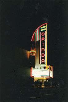
Starting in 2002, Orinda began hosting the Orinda Film Festival, an annual regional film festival taking place at the historic Orinda Theatre managed by Randy Holleschau. In 2005, actor William Hurt attended the festival to promote the film The Blue Butterfly in which he played a leading role. The festival was last held in 2005. The bright lights of the theater are visible for miles around during the night.
In August 2009, the California Independent Film Festival announced they will be making the Orinda Theatre their new home.[20] CIFF held its first event in Orinda on September 18, 2009, in which a screening of The Birds was attended by actress Tippi Hedren. The 12th Annual California Independent Film Festival was the first time the festival was held in Orinda, opening on April 22, 2010.
The California Shakespeare Theater
The internationally known California Shakespeare Theater, (a.k.a. "Cal Shakes"), performs from June to October at the Bruns Memorial Amphitheater (located on land leased from EBMUD in the hills north of Highway 24). The Theater's conservatory operates throughout the year, featuring programs for children, teenagers, young actors, teachers and adults. The current artistic director is Jonathan Moscone, son of the late San Francisco mayor.
Swimming and water polo
Several Orinda summer-league swim teams compete for a championship cup in mid-August every year. Over 2,000 individual swimmers typically participate. Orinda is also home to the popular year-round swim team, Orinda Aquatics. Orinda has raised numerous competitive swimmers (and waterpolo players) from Orinda have gone on to compete for major colleges and in the Olympics. Notables include Kirk Everist '86 (US Olympic Team '92 and '96), Heather Petri '96 (Gold: 2012 Olympics; Silver: 2000 Olympics, 2008 Olympics; Bronze: 2004 Olympics), and Michael Sharf (NCAA All-American, 2007 US National Team Member).
Tilden Regional Park
Orinda borders Tilden Regional Park, a 2,079 acre park that contains hiking trails, a golf course, Lake Anza and a Merry Go Round. The park is accessible via the Wildcat Canyon Road exit off of Camino Pablo (when traveling West).
Notable people
- Poul Anderson, science fiction author, lived in Orinda until his death in 2001
- Troy Auzenne, NFL 1991 second-round draft pick; starting left tackle for Chicago Bears and Indianapolis Colts; Kodak All-American and Hall of Fame athlete for California Golden Bears
- Bryan Barker, NFL football punter with Kansas City Chiefs, Philadelphia Eagles, Jacksonville Jaguars, Washington Redskins, Green Bay Packers and Los Angeles Rams
- Jim Barnett, Golden State Warriors player and TV color commentator on Comcast SportsNet Bay Area
- Theodore Temple (Ted) Beckett, All American (60 minute) guard, Cal Berkeley 1930; played in infamous "Wrong Way Reigels" 1929 Rose Bowl game; married to former Kay Sweetland, daughter of E. J. Sweetland of Piedmont, inventor of the automobile oil filter, Purolater; he built a home at 60 Davis Road, in 1941, had two sons, Ted Jr. (land developer in CO Springs, CO) and Riley (Attorney Carson City, NV)
- Drew Bennett, NFL wide receiver for Tennessee Titans
- Nicole Branagh, Olympic beach volleyball player
- Matt Cain, pitcher for San Francisco Giants
- Kirsten Costas, high school student murdered by her classmate, Bernadette Protti, in 1984
- Paul Dini, writer, cartoonist; lived in Orinda from 1963 to 1988
- Ken Dorsey, former quarterback for San Francisco 49ers and Cleveland Browns
- Patricia C. Dunn, former Chairwoman of the Board of Hewlett-Packard
- Sheila E., drummer and percussionist
- Adonal Foyle, NBA center for Golden State Warriors and Orlando Magic
- John Hammergren CEO of McKesson; highest-paid CEO in US 2011–2013
- John Hampton, co-founder of Toys for Tots[21]
- Sabrina Ionescu, a record breaking basketball player at Miramonte High School
- Brett Jackson, 1st Round 2009 MLB pick for Chicago Cubs Miramonte High School 2006 - Cal Berkeley All American MLB with Cubs 2012 and Diamondbacks 2014
- Robert Karplus, physicist and educator
- Hans Kelsen, one of preeminent jurists of 20th Century[22]
- Harry Arthur "Cookie" Lavagetto (1912–1990), third baseman, manager and coach in Major League Baseball, pinch-hitter whose double ruined Bill Bevens' no-hitter in Game 4 of 1947 World Series and gave his Brooklyn Dodgers a victory over New York Yankees.
- Daniel Levitin, best-selling author, cognitive neuroscientist, musician
- David Marchick, Washington, D.C. lobbyist
- Wayne F. Miller, photographer
- Karen Moe, Olympic swimming gold medalist
- William Penn Mott Jr., director of National Park Service from 1985 to 1989[23]
- Heather Petri, Olympic water polo player
- Susan Polk, Orinda housewife sentenced to 16-to-life for murder of husband, Felix Polk
- Gary Radnich, news broadcaster
- Sam Shankland, chess grandmaster and 2018 US Chess Champion
- Dana Sparks, actress and spokesperson, Falcon Crest, Passions, L.A. Law, L'Oréal, Mercedes Benz
- Owsley Stanley, audio engineer and legendary psychedelic chemist; a raid on his rented Orinda hillside house in December 1967 reportedly found a lab with 250,000 hits of LSD
- Jeremy Stoppelman, Founder of Yelp.com
- Rawson Marshall Thurber, director of Dodgeball: a True Underdog Story and "Terry Tate" commercials for Reebok
- Nicolle Wallace, political commentator, former White House Communications Director and senior adviser to John McCain's presidential campaign[24]
- Claudell Washington, former Major League Baseball player
- Will Wright, designer of computer games such as SimCity and The Sims
- Daniel Wu, a Hong Kong actor who was raised in Orinda
Neighboring cities
See also
References
- "California Cities by Incorporation Date". California Association of Local Agency Formation Commissions. Archived from the original (Word) on October 17, 2013. Retrieved March 24, 2013.
- "City Council". The City of Orinda. Archived from the original on April 24, 2013. Retrieved March 24, 2013.
- "Senators". State of California. Retrieved March 24, 2013.
- "Members Assembly". State of California. Retrieved March 24, 2013.
- "California's 11th Congressional District - Representatives & District Map". Civic Impulse, LLC. Retrieved March 9, 2013.
- "2019 U.S. Gazetteer Files". United States Census Bureau. Retrieved July 1, 2020.
- "Population and Housing Unit Estimates". United States Census Bureau. May 24, 2020. Retrieved May 27, 2020.
- "Population and Housing Unit Estimates". Retrieved May 21, 2020.
- Brennan, Morgan. "Orinda, CA - pg.3". Forbes.
- History of Orinda, Orinda Historical Society
- Durham, David L. (November 1998). "Part Five - San Francisco Bay Region". California's Geographic Names: A Gazetteer of Historic and Modern Names of the State. Word Dancer Press. p. 676. ISBN 978-1-884995-14-9. Retrieved 2009-07-22.
- "ORINDA BOWMAN, CALIFORNIA Period of Record General Climate Summary - Temperature". Western Regional Climate Center. Retrieved 23 January 2018.
- "ORINDA BOWMAN, CALIFORNIA Period of Record General Climate Summary - Precipitation". Western Regional Climate Center. Retrieved 23 January 2018.
- "Census of Population and Housing". Census.gov. Retrieved June 4, 2015.
- "2010 Census Interactive Population Search: CA - Orinda city". U.S. Census Bureau. Archived from the original on July 15, 2014. Retrieved July 12, 2014.
- https://elections.cdn.sos.ca.gov/ror/ror-odd-year-2019/politicalsub.pdf
- "Achievement - Test Scores". Orinda Union School District. Retrieved 2009-07-12.
- "AHUSD Ranks First in California". Acalanes Union High School District. Archived from the original on April 17, 2009. Retrieved 2009-07-12.
- "2010‐11 School Accountability Report Card". Retrieved November 16, 2012.
- "CIFF Newsletter". Caiff.org. 2009-08-19.
- Richards, Sam (2010-07-08). "John Hampton, co-founder of Toys for Tots, dies at 103". Contra Costa Times. Retrieved 2010-07-26.
- Michael Steven Green. "Hans Kelsen and the Logic of Legal Systems". Scholarship.law.wm.edu. Retrieved 23 January 2018.
- Daniels, Lee a (24 September 1992). "William P. Mott Jr. Is Dead at 82; Directed the National Park Service". Nytimes.com.
- "Nicolle Wallace » About Nicolle". Nicollewallace.com. Retrieved 23 January 2018.
External links
- Official website

- Orinda Chamber of Commerce
- A brief history of Orinda
- Orinda Historical Society
- Lamorinda Wiki—Wiki for Lafayette, Moraga and Orinda
Municipalities and communities of Contra Costa County, California, United States | ||
|---|---|---|
| Cities and towns | 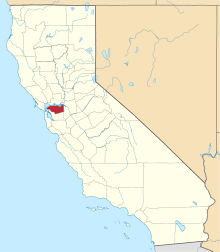 Contra Costa County map | |
| CDPs |
| |
| Former CDPs | ||
| Unincorporated communities | ||
| Ghost towns | ||
| Bodies of water |
|  |
|---|---|---|
| Counties | ||
| Major cities | ||
| Cities and towns 100k–250k | ||
| Cities and towns 50k–99k | ||
| Cities and towns 25k–50k | ||
| Cities and towns 10k–25k |
| |
| Sub-regions | ||
| Authority control |
|
|---|