Burlingame, California
Burlingame (/ˈbɜːrlɪŋɡeɪm/) is a city in San Mateo County, California. It is located on the San Francisco Peninsula and has a significant shoreline on San Francisco Bay. The city is named after diplomat Anson Burlingame and is known for its numerous eucalyptus groves, high quality of life, walkable downtown area, and excellent public school system.[9] In September 2018, the median home value in Burlingame was $2.3M. As of the 2010 U.S. Census, Burlingame had a population of 28,806.[10]
Burlingame, California | |
|---|---|
City | |
| City of Burlingame | |
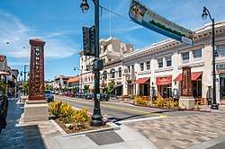 Burlingame Avenue | |
 Seal | |
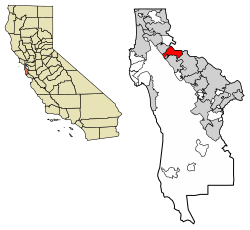 Location of Burlingame in San Mateo County, California | |
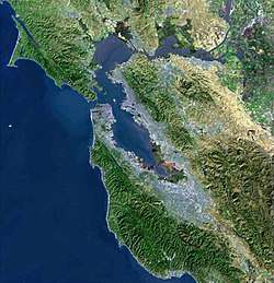
 Burlingame, California Location in the United States | |
| Coordinates: 37°35′0″N 122°21′49″W | |
| Country | |
| State | |
| Incorporated | June 6, 1908[1] |
| Named for | Anson Burlingame[2] |
| Government | |
| • Mayor | Donna Colson[3] |
| • City manager | Lisa Goldman[4] |
| Area | |
| • Total | 6.04 sq mi (15.64 km2) |
| • Land | 4.39 sq mi (11.38 km2) |
| • Water | 1.65 sq mi (4.26 km2) 27.25% |
| Elevation | 39 ft (12 m) |
| Population | |
| • Total | 28,806 |
| • Estimate (2019)[8] | 30,889 |
| • Density | 7,031.41/sq mi (2,714.88/km2) |
| Time zone | UTC-8 (Pacific) |
| • Summer (DST) | UTC-7 (PDT) |
| ZIP codes | 94010–94012 |
| Area code | 650 |
| FIPS code | 06-09066 |
| GNIS feature IDs | 1659704, 2409945 |
| Website | www |
History
Howard–Ralston Eucalyptus Tree Rows | |
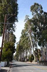 | |
| Location | El Camino Real, Burlingame, CA |
|---|---|
| Built | 1873–1876 |
| NRHP reference No. | 12000127 |
| Added to NRHP | March 15, 2012 |
Burlingame is situated on land previously owned by San Francisco-based merchant William Davis Merry Howard.[11] Howard planted many eucalyptus trees on his property and retired to live on the land. Howard died in 1856 and the land was sold to William C. Ralston, a prominent banker. In 1868, Ralston named the land after his friend Anson Burlingame, the United States Ambassador to China. After the 1906 San Francisco earthquake, hundreds of lots in Burlingame were sold to people looking to establish new homes, and the town of Burlingame was incorporated in 1908.[11] In 1910, the neighboring town of Easton was annexed and this area is now known as the Easton Addition neighborhood of Burlingame.
Burlingame refers to itself as the City of Trees due to its over 18,000 public trees within the city. In 1908, the Burlingame board of trustees passed an ordinance "prohibiting cutting, injuring, or destroying trees".[12] The city also has many parks and eucalyptus groves.
In 2018, upon the 150th anniversary of the 1868 landmark Burlingame Treaty between the U.S. and China, a new bust of diplomat Anson Burlingame, sculpted by Zhou Limin from China, was unveiled at an international ceremony at the Burlingame Public Library.[13][14]
Transportation
Highways
Three highways pass through Burlingame. Highway 101 runs from San Jose to San Francisco along San Francisco Bay. Highway 82, also known as El Camino Real, runs parallel to Highway 101 and acts as the main corridor for local traffic going up and down the peninsula. A small section of Highway 35 (Skyline Boulevard) also lies with city limits. It connects with Interstate 280, which runs along the side of Burlingame opposite Highway 101.
Caltrain
Caltrain has served Burlingame station since 1985 when it bought out Southern Pacific. It uses the same depot that was used in the early 20th century.[15]
BART
Bay Area Rapid Transit has its final stop in Millbrae, just north of Burlingame. BART's tracks are within Burlingame city limits.
Geography
According to the United States Census Bureau, the city has a total area of 6.1 square miles (16 km2). 4.4 square miles (11 km2) of it is land, and 1.7 square miles (4.4 km2) of it (27.25%) is water.[10]
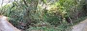
Several creeks drain across Burlingame from the peninsula hills to the San Francisco Bay.
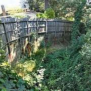 Ralston Creek
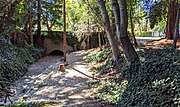 Burlingame Creek
 Sanchez Creek
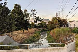
Climate
Burlingame experiences warm and dry summers, with no average monthly temperatures above 71.6 °F. According to the Köppen Climate Classification system, Burlingame has a warm-summer Mediterranean climate.[17]
Demographics
| Historical population | |||
|---|---|---|---|
| Census | Pop. | %± | |
| 1910 | 1,565 | — | |
| 1920 | 4,107 | 162.4% | |
| 1930 | 13,270 | 223.1% | |
| 1940 | 15,940 | 20.1% | |
| 1950 | 19,886 | 24.8% | |
| 1960 | 24,036 | 20.9% | |
| 1970 | 27,320 | 13.7% | |
| 1980 | 26,173 | −4.2% | |
| 1990 | 26,801 | 2.4% | |
| 2000 | 28,158 | 5.1% | |
| 2010 | 28,806 | 2.3% | |
| Est. 2019 | 30,889 | [8] | 7.2% |
| U.S. Decennial Census[18] | |||
The 2010 United States Census[19] reported that Burlingame had a population of 28,806. The population density was 6,537.9 people per square mile (2,524.4/km2). Details regarding the demographic profile are shown below.
|
The population was spread out, with 6,256 people (21.7%) under the age of 18, 1,496 people (5.2%) aged 18 to 24, 8,872 people (30.8%) aged 25 to 44, 8,136 people (28.2%) aged 45 to 64, and 4,046 people (14.0%) who were 65 years of age or older. The median age was 40.5 years. For every 100 females, there were 90.4 males. For every 100 females age 18 and over, there were 88.2 males.
There were 13,027 housing units at an average density of 2,956.7 per square mile (1,141.6/km2). There were 12,361 households with average household size of 2.29. There were 7,183 families (58.1% of all households); the average family size was 3.02.
According to the U.S. Census Bureau, American Community Survey (ACS), median household income was $122,999 and per capita income was $70,519, in 2018 dollars.[21]
Neighborhoods
|
|
Government
In the California State Legislature, Burlingame is in the 13th Senate District, represented by Democrat Jerry Hill, and in the 22nd Assembly District, represented by Democrat Kevin Mullin.[22]
In the United States House of Representatives, Burlingame is in California's 14th congressional district, represented by Democrat Jackie Speier.[23]
According to the California Secretary of State, as of February 10, 2019, Burlingame has 17,750 registered voters. Of those, 8,439 (47.5%) are registered Democrats, 3,048 (17.2%) are registered Republicans, and 5,551 (31.3%) have declined to state a political party.[24]
Economy
In the 1920s Burlingame became a popular location for automobile retailers which became known as "Auto Row".[25] In the 1960s, various airline support service businesses opened in Burlingame due to its proximity to San Francisco International Airport.[26] As of 2018, LSG/Sky Chefs, Inc. and China Airlines are all located in Burlingame. The airport location has also attracted the headquarters of medium sized multi-site companies such as Meri Meri and Proterra, Inc. Historically, Burlingame has been home to many candy and chocolate companies, including the It's-It ice cream factory and store, Guittard Chocolate,[27] the See's Candies lollipop factory,[28] and family owned candy stores Powell's, Preston's, Aida Opera Candies, and Nuts for Candy.
Since 2010, Burlingame's economy has diversified substantially and it has become an attractive location for biotechnology companies given its proximity to South San Francisco. Biotechnology companies with offices in Burlingame include Annai Systems, Breathometer, Cala Health, Cleave Biosciences, Collaborative Drug Discovery,[29] Confidence Clinical Research, Corvus Pharmaceuticals, Igenica Biotherapeutics, Kindred Biosciences, Omnitura, Phoenix Pharmaceuticals, Pulse Biosciences, Respira Therapeutics, and Vector Labs.[30]
Additionally, multiple high technology firms have established offices in Burlingame due to its location between the booming technology centers of Silicon Valley to the south and San Francisco to the north. Tech companies with Burlingame offices include: Zecco.com, Natsume, Color Genomics, CarWoo, Jobvite, DataStax, Sprint's M2M Collaboration Center, YouWeb, OpenFeint, CrowdStar, BitGravity, Veebeam, and TellApart.[31]
Education
Primary and secondary schools
- Public schools
San Mateo Union High School District operates local high schools while the Burlingame School District operates elementary and middle schools.
Burlingame High School is the city's sole public high school. Burlingame Intermediate School is Burlingame's sole public middle school. There are six public elementary schools serving Burlingame. They are Franklin Elementary, Lincoln Elementary, McKinley Elementary, Roosevelt Elementary, Washington Elementary, and Hoover Elementary.[32] According to the 2009 Base Academic Performance Index (API) Scores from the California Department of Education, the Burlingame School District ranks among the best in the state, with 4 out of their 6 public elementary schools (Roosevelt Elementary, Washington Elementary, Franklin Elementary, and Lincoln Elementary) scoring well between 880 and 925, and with ratings of 9 or 10.[33] Burlingame school district enrollment has continually been increasing as young families move to the city. The city has passed two bond measures to add new facilities and modernize existing facilities to provide state-of-the-art classrooms. The city recently extensively renovated and modernized the Hoover School, which was built in 1931 and reopened in 2016.
- Private schools
Mercy High School is a private Catholic all-girls high school in Burlingame. It was founded in 1931 by the Sisters of Mercy. The school is located in the Kohl Mansion which is a Historic Landmark.[34] Our Lady of Angels School and St. Catherine of Siena School are located in Burlingame.
Public libraries
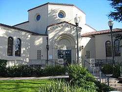
Burlingame Library is located in Burlingame. It was established by city ordinance October 11, 1909. Following the Loma Prieta earthquake in 1989, the City approved a bond issue to reconstruct the library. The architecture has won awards and earned a cover story in the 1998 American Libraries journal.[35] A second branch, located on Easton Drive, is substantially smaller than the main branch. Both are operated by the Peninsula Library System, the library authority for the county.
Points of interest
- Burlingame Avenue and Broadway, two streets running parallel to each other about one mile apart, are two of the city's main retail districts.[36]
- Burlingame Station, a Caltrain station in Burlingame, is listed on the National Register of Historic Places.[37]
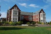
- Kohl Mansion is a 63-room brick Tudor-style mansion on 40 acres of land. It was originally built by Bessie and Frederick Kohl, with architects Howard and White, and completed in 1914. The estate included tennis courts, greenhouses, a rose garden, a large carriage house, and a 150,000 gallon reservoir. In 1921, the silent version of the film Little Lord Fauntleroy, with Mary Pickford, was filmed in the Kohl Mansion. The mansion, sold to the Sisters of Mercy in 1924, was a convent from 1924 to 1931, and it has been the home of Mercy High School since 1931.[38]
- Burlingame Museum of PEZ Memorabilia was located off of Burlingame game avenue and claimed to have every Pez dispenser ever sold. It was founded in 1995 by Gary and Nancy Doss who had been collecting Pez Dispensers for more than a decade. The Pez Museum was featured in Time Magazine, on the Discovery Channel, and on the Travel Channel. It closed in July, 2019
Notable people
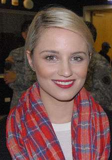
- Dianna Agron, actress from Glee, attended Burlingame Intermediate School and Burlingame High School
- Bill Amend, author of the comic strip FoxTrot, attended Burlingame High School
- Travis Bader, basketball player, attended Burlingame Intermediate School and Burlingame High School
- David Bakhtiari, starting offensive tackle for the Green Bay Packers, lives in Burlingame
- Marc Benioff, founder and CEO of Salesforce.com, attended Burlingame High School
- Sally Dryer, actress known for voicing Lucy Van Pelt in Peanuts holiday specials
- Scott Feldman, Major League Baseball pitcher for the Cincinnati Reds
- Leon Gilmour, (1907–1996) wood engraving artist, died in Burlingame[41]
- Percy Gray, artist and painter, lived in Burlingame from 1912 to 1923
- Hannah Hart, comedian and YouTuber, was raised in Burlingame
- Charles S. Howard, owner of Seabiscuit, owned a home in Burlingame
- Shirley Jackson, author, whose The Road Through the Wall is set in Burlingame
- Jung-Ho Pak, orchestra conductor, was born in Burlingame
- George Kelly, Hall of Fame baseball player nicknamed "High Pockets," lived and died in Burlingame
- Adam Klein, winner of Survivor: Millennials vs Gen X, attended Burlingame High School[42]
- Tom Lantos, Democratic Congressman who resided in Burlingame during his time in office.[43]
- Tamora Pierce, best-selling children's author, attended Burlingame Intermediate School
- Leonard Read, founder of the Foundation for Economic Education, lived in Burlingame
- Hank Sauer, two-time All-Star outfielder for Chicago Cubs, died in Burlingame
- Brad Schreiber, author and TV writer-producer, attended Burlingame High School and lived in mayor's mansion at 238 Myrtle Road
In popular culture
- In The Maltese Falcon, Sam Spade rushes to 26 Ancho Street in Burlingame to rescue Brigid O'Shaughnessy.[44]
- Scenes from the film Dangerous Minds were filmed on the campus of Burlingame High School in the spring of 1994.[45]
- Burlingame is home to the historic Kohl Mansion, where the movie Flubber was filmed.[46]
- In James Patterson's Women's Murder Club series, San Francisco Assistant District Attorney Jill Bernhardt lives in Burlingame.
- Leo Wyatt, character from the series Charmed, was born in Burlingame.
- Sam Hill, the protagonist in Robert Dugoni's The Extraordinary Life of Sam Hell, is born and raised in Burlingame.
See also
References
- "California Cities by Incorporation Date". California Association of Local Agency Formation Commissions. Archived from the original (Word) on November 3, 2014. Retrieved August 25, 2014.
- "About Burlingame". City of Burlingame, California. Archived from the original on February 9, 2007. Retrieved February 25, 2015.
- "Meet the Council". City of Burlingame, California. Archived from the original on May 15, 2019. Retrieved May 14, 2019.
- "City Manager". City of Burlingame, California. Archived from the original on March 21, 2019. Retrieved May 14, 2019.
- "2019 U.S. Gazetteer Files". United States Census Bureau. Retrieved July 1, 2020.
- "Burlingame". Geographic Names Information System. United States Geological Survey. Retrieved October 10, 2014.
- "Burlingame (city) QuickFacts". United States Census Bureau. Archived from the original on 2015-03-23. Retrieved March 15, 2015.
- "Population and Housing Unit Estimates". United States Census Bureau. May 24, 2020. Retrieved May 27, 2020.
- "California School Ratings". www. school-ratings.com. Retrieved 2018-09-17.
- "U.S. Census Bureau QuickFacts: Burlingame city, California". www.census.gov. Retrieved 2018-02-10.
- "History of Burlingame". www.burlingame.org. Retrieved February 10, 2018.
- "Urban Reforestation and Tree Protection" Burlingame Municipal Code
- "Anson Burlingame Bust Unveiled in Library". Burlingame Historical Society. Burlingame, California. 16 November 2018. Retrieved 8 May 2019.
- "The Unveiling Of The Bust Of Anson Burlingame". dingdingtv.com. Silicon Valley Innovation Channel. Retrieved 8 May 2019.
- "Wayback Machine" (PDF). 2018-10-18. Archived from the original (PDF) on 2018-10-18. Retrieved 2020-01-29.
- "Public Transportation Links". Archived from the original on 2017-11-07. Retrieved 2018-12-30.
- "Burlingame, California Köppen Climate Classification (Weatherbase)". Weatherbase. Retrieved 2018-02-10.
- "Census of Population and Housing". Census.gov. Retrieved June 4, 2015.
- "2010 Census Interactive Population Search: CA – Burlingame city". U.S. Census Bureau. Archived from the original on July 15, 2014. Retrieved July 12, 2014.
- "Demographic Profile Bay Area Census".
- "Population estimates, July 1, 2019, (V2019)". www.census.gov. Retrieved 2020-08-18.
- "Statewide Database". UC Regents. Archived from the original on February 1, 2015. Retrieved December 3, 2014.
- "California's 14th Congressional District - Representatives & District Map". Civic Impulse, LLC. Retrieved March 12, 2013.
- "CA Secretary of State – Report of Registration – February 10, 2019" (PDF). ca.gov. Retrieved March 12, 2019.
- "Auto Row - Burlingame Chamber of Commerce". Burlingame Chamber of Commerce. Retrieved 2017-02-17.
- "Best Places to Live: Burlingame." San Jose Magazine. Retrieved on January 25, 2009.
- "Our Company". www.guittard.com. Guittard Chocolate Company. Retrieved 2018-02-10.
- "Our Timeline | See's Candies". www.sees.com. Retrieved 2018-02-10.
- trademark., Collaborative Drug Discovery, Inc. CDD Vault® is a registered. "Contact Us | Collaborative Drug Discovery". info.collaborativedrug.com. Retrieved 2018-02-11.
- "Links to biotechnology, pharmaceutical & medical device companies in Northern California". biopharmguy.com. Retrieved 2017-02-17.
- "Burlingame becoming new tech hub – The Mercury News". 2011-07-24. Retrieved 2017-02-17.
- "Burlingame: After closing nearly 40 years ago, Hoover Elementary reopens". The Mercury News. 2016-08-24. Retrieved 2018-02-11.
- "2009 Base API County List of Schools - San Mateo County". api.cde.ca.gov. Retrieved 2018-02-11.
- Mercy High School Burlingame: Sisters of Mercy. Mercyhsb.com. Retrieved on 2013-07-21.
- "Welcome to Burlingame Library". www.burlingame.org. Retrieved 2020-01-29.
- City of Burlingame, California : Dining and Shopping Archived 2017-07-17 at the Wayback Machine. Burlingame.org (2012-02-05). Retrieved on 2013-07-21.
- "Asset Detail". npgallery.nps.gov. Retrieved 2018-02-11.
- "History of the Kohl Mansion - Mercy High School Burlingame". www.mercyhsb.com. Archived from the original on 2017-02-17. Retrieved 2017-02-17.
- Friedman, Jan (2005). Eccentric California. Bradt Travel Guides. p. 22. ISBN 9781841621265.
- Bigley, Michele. Explorer's Guide Northern California. The Countryman Press. p. 182. p. 182. ISBN 9781581579499.
- "Artist Biography for Leon Gilmour". Askart.com. Retrieved 2018-07-02.
- staff, Austin Walsh Daily Journal. "Burlingame native wins 'Survivor': Adam Klein earns $1 million for defeating 19 others on popular reality TV show". San Mateo Daily Journal. Retrieved 2018-08-30.
- Barone, Michael; Ujifusa, Grant (1987). The Almanac of American Politics 1988. National Journal. p. 105.
- "Burlingame: Paradise on the Peninsula". SFGate. Retrieved 2018-02-11.
- "Michelle Pfeiffer Acts With Class / 'Dangerous Minds' uses teacher plot well". SFGate. Retrieved 2018-02-11.
- "Kohl Mansion has its roots in The Oaks". SFGate. Retrieved 2018-02-11.
External links
| Wikivoyage has a travel guide for Burlingame. |
- Official website

- Burlingame Public Library
- Burlingame School District
- Burlingame Historical Society
- Downtown Burlingame Directory
Municipalities and communities of San Mateo County, California, United States | ||
|---|---|---|
| Cities and towns | 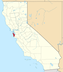 San Mateo County map | |
| CDPs | ||
| Unincorporated communities | ||
| Ghost towns | ||
| Bodies of water |
|  |
|---|---|---|
| Counties | ||
| Major cities | ||
| Cities and towns 100k–250k | ||
| Cities and towns 50k–99k | ||
| Cities and towns 25k–50k | ||
| Cities and towns 10k–25k |
| |
| Sub-regions | ||
| Authority control |
|
|---|