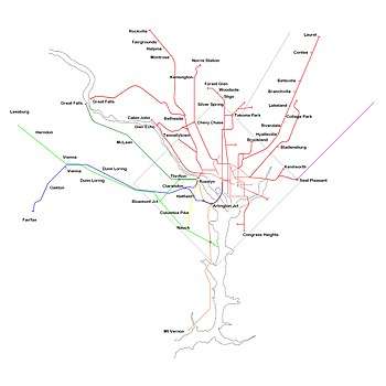
Northern Virginia trolleys
The earliest electric railway, or streetcar line, in Northern Virginia opened in 1892. At their peak, when merged into a single interurban system (the Washington-Virginia Railway), the successors of this and several other lines ran between downtown Washington, D.C., Rosslyn and Arlington Junction – in present-day Crystal City – and out to Mount Vernon, Fairfax City and Nauck (in Arlington County).[1]
 Mount Vernon trolley terminal between 1910 and 1920 | |
| Operation | |
|---|---|
| Began operation | 1892 |
| Ended operation | 1939 |
| Technical | |
| Track gauge | (?) |
| Minimum radius of curvature | (?) |
| Electrification | 1892 |

(1) The Washington-Mount Vernon line of the Washington-Virginia Railway (the "Washington, Alexandria, and Mount Vernon Electric Railroad");
(2) The East Arlington branch of the Washington-Virginia Railway (to the east of Arlington House);
(3) The Great Falls Division of the Washington and Old Dominion Railway (the "Great Falls Electric Railroad"); and,
(4) The Washington and Great Falls Electric Railway (the "Glen Echo Electric Railroad")
Orange = Washington, Arlington & Mount Vernon Electric Railway.
Blue = Washington, Arlington & Falls Church Railway (WA&FC).
Yellow = Nauck (Fort Myer) line of WA&FC.
Light green = W&OD Bluemont Division.
Dark green = W&OD Great Falls Division.
Electric trolleys also went west from Georgetown and Rosslyn on the Washington and Old Dominion Railway's (W&OD's) Bluemont Division, traveling through Herndon and Leesburg to reach the town of Bluemont at the base of the Blue Ridge Mountains. Those on the W&OD's Great Falls Division traveled from Georgetown and Rosslyn via Cherrydale and McLean to Great Falls (see: Great Falls and Old Dominion Railroad).
Despite early success, the trolleys were unable to compete with the automobile and with each other. Plagued with management and financial problems, the last ended their operations in the 1930s and early 1940s during the Great Depression.
Northern Virginia's trolleys were originally operated by three different companies that all planned to operate within the District of Columbia and were never integrated into the Washington streetcar network (see: Streetcars in Washington, D.C.). Their tracks were laid when most of Northern Virginia was undeveloped and had few streets and roads.
As a result, the trolleys mostly operated on private right-of-ways that their companies leased or owned. After they began operating, a number of communities developed along their routes.
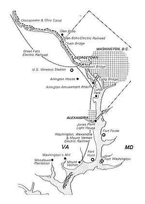
The major lines of the Washington-Virginia Railway converged at Arlington Junction, which was located in the northwest corner of the present-day Crystal City south of The Pentagon.[2] The Railway's trolleys then crossed the Potomac River near the site of the present 14th Street bridges over the Long Bridge and, beginning in 1906, the Highway Bridge.
The trolleys then traveled to a terminal in downtown Washington located along Pennsylvania Avenue, NW, and D Street, NW, between 12th and 13 1/2 Streets, NW, on a site that is now near the Federal Triangle Metro station and the Old Post Office building within the Federal Triangle. The W&OD Railway terminated in Georgetown at a station on the west side of the Georgetown Car Barn after crossing the Potomac River from Rosslyn over the Aqueduct Bridge.
The Washington-Virginia Railway and the W&OD Railway had adjacent stations in Rosslyn near the present location of the Key Bridge Marriott Hotel, permitting travelers to transfer between the two trolley systems. After the Francis Scott Key Bridge replaced the Aqueduct Bridge in 1923, none of the Virginia lines terminated in Georgetown. Instead, Washington streetcars crossed the river on the new bridge and entered a turnaround loop within Rosslyn. There, passengers could transfer between trolleys whose lines separately served Washington and Northern Virginia.
Washington-Virginia Railway
Washington, Alexandria, and Mount Vernon Electric Railway
Washington-Mount Vernon line
The Washington, Alexandria, and Mount Vernon Electric Railway began operating between Alexandria and Mount Vernon in 1892. On August 23, 1894, it was given permission to enter the District of Columbia using a boat or barge. However, the railroad never actually used any such watercraft.[3]
The railroad completed its tracks in 1896 and began serving a waiting station at 14th Street NW and B Street NW in downtown Washington, D.C. From the waiting station it used the Belt Line Street Railway Company's tracks on 14th Street NW to reach the Long Bridge, a combined road and rail crossing of the Potomac River.[3]
In 1902, the railroad moved its station, as the Belt Line's tracks were circling the block containing the site of a planned new District Building (now the John A. Wilson Building). The new station (address: 1204 N. Pennsylvania Avenue) extended along Pennsylvania Avenue, NW, and D Street, NW, from 12th Street, NW, to 13 1/2 Street, NW, near the site of the present Federal Triangle Metro station and on the opposite side of 12th Street from the Old Post Office building.[3][4][5][6]
In 1906, the Long Bridge's streetcar tracks and road were relocated to a new truss bridge (the Highway Bridge), immediately west of the older bridge.[3][7] This span was removed in 1967.[8]
After crossing the Potomac River, the trolleys entered Arlington County (named Alexandria County before 1920) to run southward near and along the present route of Interstate 395 (I-395). They then reached Arlington Junction, whose site is now in the northwest corner of Crystal City west of Richmond Highway (U.S Route 1) and south of The Pentagon and I-395. At the Junction, the line's route diverged from that of a line that traveled west to Fairfax City and which connected to others that served Arlington National Cemetery, Rosslyn and Nauck.
After leaving Arlington Junction, trolleys on the Washington-Mount Vernon line continued south along the present route of S. Eads Street while travelling largely on the grade of a towpath on the west side of the defunct Alexandria Canal.[9][10] Near Arlington's present southern border at Four Mile Run, the railroad and its affiliates constructed an amusement park (Luna Park) and a rail yard containing a car barn and a power plant.[9]
After crossing Four Mile Run into present-day Alexandria, the trolleys continued to travel south along the present route of Commonwealth Avenue. The Mount Vernon line then passed under a bridge at St. Elmo that carried the Bluemont branch of the Southern Railway and later the branch's successor, the Bluemont Division of the W&OD Railway. The lines' St. Elmo stations, located in Alexandria's present Del Ray neighborhood, gave travelers an opportunity to transfer between the railroads.[11]
The Mount Vernon line's trolleys then continued southward along Commonwealth Avenue until reaching King Street near Alexandria's Union Station. The line's trolleys then turned to travel east on King Street until they reached a station at Royal Street, in the center of Old Town Alexandria next to Market Square. They then turned again, traveled south on S. Royal Street and crossed Hunting Creek to enter Fairfax County on a 3,500 feet (1,067 m)-long bridge containing a concrete and steel center span and trestle.[12]
After traveling through New Alexandria, where the line had originated,[12] the trolleys continued south through Fairfax County at speeds of up to 30 miles (48 km) per hour[12] while traveling partially along the present routes of the George Washington Memorial Parkway, East Boulevard Drive and Wittington Boulevard. After crossing Little Hunting Creek, they reached a turnaround loop on which they traveled to a terminal constructed near the entrance to the grounds of George Washington's home in Mount Vernon.
At Mount Vernon, when the electric railway began service, the estate's proprietors insisted that only a modest terminal be constructed next to the trolley turnaround. They were afraid that the dignity of the site would be marred by unrestricted commercial development and persuaded financier Jay Gould to purchase and donate thirty-three acres outside the main gate for protection.
By 1906, the railway had transported 1,743,734 passengers along its routes with 92 daily runs. Passengers and others could read a 122-page Hand-book for the Tourist Over the Washington, Alexandria and Mount Vernon Electric Railway that described in detail the railway's routes and stations as well as the landmarks, history and geography of the area through which the railway traveled.[13]
In 1913, the Washington, Alexandria, and Mount Vernon Electric Railway merged with the Washington, Arlington & Falls Church Railway to form the Washington-Virginia Railway. During World War I, the railroad company extended the Washington-Mount Vernon line to Camp Humphreys (now Fort Belvoir).[12] As the company received only partial compensation for constructing the extension, the action placed a financial burden on the company.[12] The company went into receivership in 1923 when buses became the dominant form of local public transportation (see: History of surface transit in Northern Virginia).
In 1927, the two railways were separated and sold at auction, the Washington-Mount Vernon line becoming the Washington, Alexandria and Mount Vernon Railway. The last trolleys of the line ran on January 18, 1932. Later that year the tracks were removed when some of the right-of-way was used for the George Washington Memorial Parkway. The path of the trolley turnaround at Mount Vernon remains as a traffic circle at the south end of the Parkway, while the former rail yard in southern Arlington now serves as a Metrobus yard.
Stations
The stations on the Washington-Mount Vernon Line of the Washington, Alexandria, and Mount Vernon Electric Railway (Alexandria-Mount Vernon Branch of the Washington-Virginia Railway)[14] were (with locations of sites in 2008):
| Station | Location[15] | Jurisdiction | Miles from Washington Terminal[5] |
Notes | Coordinates | Image |
|---|---|---|---|---|---|---|
| Camp Humphreys | Fort Belvoir | Fairfax County | ||||
| Mount Vernon[5] | South side of traffic circle at Mount Vernon Estate | Fairfax County | 15.8 | 38°42′39″N 77°05′12″W | Mount Vernon trolley terminal between 1910 and 1920 | |
| Oakwood | George Washington Memorial Parkway | Fairfax County | 38°42′56″N 77°05′06″W | |||
| Miller | Near west bank of Little Hunting Creek | Fairfax County | 38°43′04″N 77°04′38″W | |||
| Riverside[5] | Wittington Boulevard and Bluedale Street | Fairfax County | 14.7 | |||
| Hunter[5] | Wittington Boulevard and Elkin Street | Fairfax County | 14.2 | 38°43′22″N 77°03′54″W | ||
| North Mount Vernon | Fort Hunt Road (Virginia State Route 629), south of Old Stage Road | Fairfax County | 38°43′30″N 77°03′34″W | |||
| Grassymead[5] | East of Fort Hunt Road, north of Waynewood Boulevard | Fairfax County | 13.1 | 38°43′39″N 77°03′20″W | ||
| Snowden[5] | West Boulevard Drive and Collingwood Road (Virginia State Route 628) | Fairfax County | 13.1 | Named for Isaac, William and Stacey Snowden[16] | 38°43′56″N 77°02′54″W | |
| Herbert Springs[5] | East Boulevard Drive and Herbert Springs Road | Fairfax County | 12.9 | |||
| Arcturus[5] | East Boulevard Drive and Arcturus Lane | Fairfax County | 12.8 | |||
| Wellington[5] | East Boulevard Drive, southwest of Wellington House at River Farm | Fairfax County | 12.5 | 38°44′26″N 77°02′51″W | ||
| Bellmont[5] (Wellington Villa) |
George Washington Memorial Parkway and Alexandria Avenue | Fairfax County | 12.1 | 38°44′48″N 77°02′56″W | ||
| Happy Home | Fairfax County | |||||
| Warwick | George Washington Memorial Parkway and Morningside Lane | Fairfax County | 38°45′07″N 77°03′00″W | |||
| Dyke[5] | George Washington Memorial Parkway | Fairfax County | 11.3 | 38°45′34″N 77°02′56″W |  Washington, Alexandria, and Mount Vernon Electric Railway near Dyke Marsh with station in background. 1930 | |
| Oaks | George Washington Memorial Parkway | Fairfax County | 38°45′49″N 77°03′08″W | |||
| New Alexandria[5] | Potomac Avenue and Belle Haven Road | Fairfax County | 9.6 | 38°46′50″N 77°03′23″W | ||
| Unnamed | Near S. Royal Street and Hunting Creek | City of Alexandria | 38°47′32″N 77°02′46″W | |||
| Alexandria[5][14] | King and Royal Streets | City of Alexandria | 7.7 | 38°48′17″N 77°02′37″W | ||
| Spring Park (later Union Station)[5] | King Street and Commonwealth Avenue | City of Alexandria | 6.7 | 38°48′24″N 77°03′35″W | ||
| Rosemont | Rosemont Avenue and Commonwealth Avenue | City of Alexandria | 38°48′36″N 77°03′39″W | |||
| North Rosemont | Walnut Street and Commonwealth Avenue | City of Alexandria | 38°48′44″N 77°03′42″W | |||
| Braddock[5][14][17] | Braddock Road and Commonwealth Avenue | City of Alexandria | 6.0 | 38°48′59″N 77°03′45″W | ||
| North Braddock[14] | Commonwealth Avenue | City of Alexandria | ||||
| Lloyd[5][14] | Windsor Avenue and Commonwealth Avenue | City of Alexandria | 5.7 | 38°49′27″N 77°03′45″W | ||
| Del Ray[5][14] | Del Ray Avenue and Commonwealth Avenue | City of Alexandria | 5.6 | 38°49′33″N 77°03′43″W | ||
| Mount Ida[14] | Mount Ida Avenue and Commonwealth Avenue | City of Alexandria | Historical marker near site of station: The Electric Railway[18][19] | 38°49′42″N 77°03′39″W | ||
| St. Asaph[5] | Commonwealth Avenue, between Forrest Street and Ancell Street | City of Alexandria | 5.6 | Served St. Asaph Racetrack. (1894–1905)[20] Historical marker near site of station: St. Asaph Racetrack[20][21] |
38°49′47″N 77°03′36″W |
|
| Hume[14] | Intersection of Hume Avenue, Mount Vernon Avenue and Commonwealth Avenue | City of Alexandria | Historical marker near site of station: Mount Vernon Avenue[22][23] | 38°49′51″N 77°03′35″W | ||
| St. Elmo[5][14][24] | Commonwealth Avenue near Ashby Street | City of Alexandria | 4.8 | Crossing of W&OD Railway's Bluemont Division Historical marker near site of station: The Bluemont Line[25][26] |
38°49′59″N 77°03′32″W | |
| Four Mile Run[5][14] | Near present intersection of S. Glebe Road and S. Eads Street | Arlington County | 4.1 | Historical marker near site of station: Transportation[9][27] | 38°50′33″N 77°03′17″W | |
| Car Barn | In bus yard east of S. Eads Street | Arlington County | Formerly in rail yard[9] | 38°50′43″N 77°03′14″W | ||
| Luna Park[28] | West side of S. Eads Street | Arlington County | Adjacent to amusement park in present site of sewage treatment plant[9] | 38°50′43″N 77°03′14″W | ||
| Aurora Hills[14] | 26th Street S. and S. Eads Street | Arlington County | 38°51′02″N 77°03′13″W | |||
| Virginia Highlands[14] | 23rd Street S. and S. Eads Street | Arlington County | 38°51′12″N 77°03′12″W | |||
| Addison[5][14][29] | 18th Street S. and S. Eads Street | Arlington County | 3.2 | 38°51′27″N 77°03′11″W | ||
| Arlington Junction[5][14][30] | Between Army-Navy Drive and 12th Street S and between S. Eads Street and Richmond Highway (U.S. Route 1) | Arlington County | 2.7 | Junction with the East Arlington branch of the Washington, Alexandria, and Mount Vernon Railway and later with the South Arlington branch of the Washington—Virginia Railway | 38°51′50″N 77°03′12″W | |
| South Washington | Near I-395 | Arlington County | 38°52′00″N 77°02′56″W | |||
| Alexander Island[5][14] | Near I-395 between Boundary Channel Drive and George Washington Memorial Parkway | Arlington County | 2.1 | 38°52′15″N 77°02′40″W | ||
| Washington Terminal[14] | 1204 N. Pennsylvania Avenue[4] West side of 12th Street, NW, between Federal Triangle Metro Station and Pennsylvania Avenue, NW |
District of Columbia | 0 | At corner of 13 & 1/2 Street, NW, and Pennsylvania Avenue, NW, in 1902.[5] | 38°53′41″N 77°01′42″W |
Remnants of the Washington-Mount Vernon line
- Roads
- Wittington Boulevard, Fairfax County. Coordinates: 38°43′17″N 77°04′07″W
- East Boulevard Drive, Fairfax County. Coordinates: 38°44′18″N 77°02′49″W
- Potomac Avenue, Fairfax County. Coordinates: 38°46′26″N 77°03′26″W
- Commonwealth Avenue, Alexandria. Coordinates: 38°49′28″N 77°03′45″W
- South Eads Street, Arlington. Coordinates: 38°51′04″N 77°03′13″W
- Metrobus yard
- Former rail yard at S. Eads Street (east side) and S. Glebe Road (north side), Arlington. Coordinates: 38°50′40″N 77°03′13″W
- Traffic circle
- Former trolley turnaround at Mount Vernon estate, Fairfax County. Coordinates: 38°42′41″N 77°05′10″W
- Tracks - In May of 2020, during repair of a water main on King Street, a work crew of the Alexandria Department of Transportation and Environmental Services discovered old tracks buried under the pavement.[31]
East Arlington branch
The Washington, Alexandria, and Mount Vernon Electric Railway constructed the East Arlington branch, which traveled from Arlington Junction to the Virginia end of the Aqueduct Bridge in Rosslyn.[30] After leaving Arlington Junction, the East Arlington branch traveled northwest along a route that was south of the future site of The Pentagon, crossed Columbia Pike and entered Mt. Vernon Junction. At that Junction, the East Arlington branch met the South Arlington branch, which the Washington, Arlington & Falls Church Railroad constructed.
After leaving Mt. Vernon Junction, the East Arlington branch crossed the southern boundary of the federally-owned "Arlington Reservation". The site of the crossing was at that time near the southeast corner of Arlington National Cemetery, which was within the Reservation. After entering the Reservation, the branch turned to travel north along the eastern side of Arlington Ridge Road (formerly named the Alexandria & Georgetown Turnpike), which was outside of the Cemetery near the Cemetery's eastern wall.
While traveling next to Arlington Ridge Road, the branch passed the Cemetery's McClellan and Sheridan Gates. An expansion of the Cemetery later encompassed this portion of the Road, whose route no longer exists within the Cemetery.
Construction of the branch permitted visitors from Washington, D.C., to reach the Cemetery by rail for the first time. However, after leaving the trolleys outside of the Sheridan Gate at the branch's Arlington station, visitors needed to ascend a steep hill to reach most of the Cemetery's well-known features and burial sites.
After passing its Arlington station, the branch crossed the north boundary of the Reservation and turned to travel northwest until it met Rosslyn's Chadwick Avenue (now named N. Lynn Street), on which it traveled north. The branch ended near the Aqueduct Bridge at the railway's Rosslyn terminal.[4][32]
East Arlington branch stations
The stations of the East Arlington branch were (with locations of sites in 2008):
| Station | Location[15] | Jurisdiction | Notes | Coordinates |
|---|---|---|---|---|
| Rosslyn[14][33] | N. Lynn Street near Key Bridge Marriott Hotel | Arlington County | East of W&OD Railway station. 1925 photo[34] | 38°53′59″N 77°04′15″W |
| Arlington[35] | Arlington National Cemetery | Arlington County | Outside of the now-demolished Sheridan Gate of Arlington National Cemetery (location now inside the cemetery)[36] | 38°53′05″N 77°04′01″W |
| Queen City[37] | Near present crossing of Columbia Pike and South Joyce Street | Arlington County | Outside of the south boundary of Arlington National Cemetery | 38°52′14″N 77°03′56″W |
| Mount Vernon Junction[14] | Near present east crossing of Columbia Pike (Virginia State Route 244) and Washington Boulevard (Virginia State Route 27) | Arlington County | Junction with South Arlington branch of Washington, Arlington & Falls Church Railway | 38°52′11″N 77°03′42″W |
| Relee[14] | I-395 between S. Fern Street and S. Eads Street, south of The Pentagon | Arlington County | Named for Robert E. Lee | 38°51′56″N 77°03′20″W |
| Arlington Junction[14][30] | Between Army-Navy Drive and 12th Street S and between S. Eads Street and Richmond Highway (U.S. Route 1) | Arlington County | Junction with Washington-Mount Vernon line | 38°51′50″N 77°03′12″W |
Washington, Arlington & Falls Church Railway
During its forty years of life, this interurban trolley company operated under a variety of names, as it repeatedly expanded, reorganized or contracted (voluntarily or involuntarily).
Washington & Arlington — 1892–1896
On February 28, 1891, the United States Congress enacted a statute that incorporated the Washington and Arlington Railway Company in the District of Columbia, with authorization to reach Fort Myer and the northwest entrance of Arlington National Cemetery (the Cemetery's Fort Myer Gate) by crossing the Potomac River on a new bridge that the company would construct at or near the "Three Sisters" islets.[38] The system started in 1892, as a horsecar line with tracks from Rosslyn up the hill to the Cemetery's Fort Myer Gate - this would later become the Nauck Line. In late 1895, the system was electrified. The company never constructed its planned "Three Sisters" bridge (see Early proposals for Three Sisters Bridge).
Washington, Arlington & Falls Church — 1896–1913
In 1896, track was laid from Rosslyn through Clarendon and Ballston to Falls Church, constituting the North Arlington Branch and part of the Fairfax Line, and the name was changed to the Washington, Arlington & Falls Church (WA&FC). The track though Fort Myer was extended past the northwest entrance to Arlington National Cemetery to reach Penrose in 1900 and Nauck, just north of Four Mile Run, in 1901. That same year saw the opening of about a mile of additional track, extending from East Falls Church to West Falls Church. Work on a far more ambitious extension began at West Falls Church in 1903, bringing the line through Dunn Loring and Vienna in 1904 to reach the Fairfax County Courthouse in Fairfax City.[39] Between 1900 and 1904, the W.A & F.C. built the South Arlington branch from Clarendon to Mount Vernon Junction (south of Arlington National Cemetery), where it met the Washington, Alexandria and Mt. Vernon Railway's East Arlington branch, which traveled between Rosslyn and Arlington Junction.
Washington - Virginia — 1913–1927
In 1913, the WA&FC and Washington, Alexandria & Mt. Vernon were merged to form the Washington - Virginia (W-V) Railway, whereupon the WA&FC became the W-V's Falls Church Division.[6] The company fell upon hard times and in 1924 declared bankruptcy. In 1927, the two companies were split and sold at auction.

Arlington & Fairfax — 1927–1936
The Arlington & Fairfax was organized by local governments to take control of the WA&FC line after the W-V went bankrupt. The South Arlington Branch was shut down, the tracks pulled up in 1931 and the right of way used to build part of Washington Boulevard.[40] In 1932, the company lost the right to travel into D.C., and, on January 17, 1932, the last Arlington & Fairfax streetcar departed from 12th & D Streets, NW, abandoning all service in Washington, D.C.
Arlington & Fairfax Auto Railroad — 1936–1939
In 1936, the company was sold to Detroit's Evans Products Company, an innovative railway and automotive industry supplier that had developed the first version of the present hy-rail system called auto-railers, small buses that can run on rails on flanged wheels or on roads with rubber (see Road–rail vehicle).[41] In 1937, Evans replaced the trolleys with auto-railers. On rail, they went to Rosslyn where they were intended to switch to tires and cross the Key Bridge into Georgetown, eliminating the change in Rosslyn, but Capital Transit prevented that service by objecting that its franchise gave it exclusive service across the bridge. The auto-railers last ran in September 1939.
Nauck line (Fort Myer line)
Originally constructed by the Washington, Arlington and Falls Church Railroad, the Nauck line (Fort Myer line) of the Washington—Virginia Railway ran south from Rosslyn through Fort Myer to an initially lightly developed area in South Arlington near Four Mile Run.[42] After leaving the railroad's Rosslyn terminal near the Aqueduct Bridge, the line travelled south through Fort Myer Junction along the present routes of N. Lynn Street and N. Meade Street.
The line then turned to the southwest and crossed the northern boundary of the Arlington Reservation and Fort Myer near today’s Wright Gate. Within the Fort, trolleys on the line climbed a hill along the present route of McNair Road near the western wall of Arlington National Cemetery to reach a station (Arlington Fort Myer) located within the Fort at the present intersection of McNair Road and Lee Avenue, near the Cemetery's Fort Myer Gate (Chapel Gate of Fort Myer).
After disembarking at the Arlington Fort Myer station, visitors could enter the Cemetery near its highest elevation. This permitted visitors to avoid the ascent required when entering the Cemetery through the Sheridan Gate after traveling on the East Arlington branch to that branch's Arlington station. After the East Arlington branch closed in 1921, the Nauck line provided the only rail service that visitors could use to reach the Cemetery.
After leaving the Arlington Fort Myer station, the line traveled south through Fort Myer before turning southwest to cross the South Arlington branch of the railroad's Fairfax line at Hatfield Junction. Passengers could transfer between the two lines at the railroad's adjacent Hatfield station.
Soon after leaving Hatfield Junction and continuing to travel southwest, the Nauck line crossed the west boundary of the Reservation and the Fort, a short distance north of the Fort's Hatfield Gate. The line then crossed the present path of Washington Boulevard (Virginia State Route 27), south of the Boulevard's crossing of Arlington Boulevard (U.S. Route 50)
The Nauck line then traveled southwest and south while partially following the present routes of S. Uhle Street and Walter Reed Drive. After crossing S. Glebe Road (now Virginia State Route 120), the line traveled downhill near the west side of S. Kenmore Street to end at a railway turntable near the intersection of 24th Road S. and S. Kenmore Street. The line terminated a short distance north of the Cowdon (Nauck) station of the Southern Railway, and later, of the W&OD Railway's Bluemont Division.[43]
Nauck line stations
The stations of the Nauck line (Fort Myer-Arlington Branch of the Washington-Virginia Railway)[14] were (with locations of sites in 2008):
| Station[14] | Location[15] | Jurisdiction | Notes | Coordinates | Image |
|---|---|---|---|---|---|
| Rosslyn[33] | N. Lynn Street near Key Bridge Marriott Hotel | Arlington County | East of W&OD Railway station | 38°53′59″N 77°04′15″W | |
| Fort Myer Junction | East of intersection of Fairfax Drive and N. Lynn Street | Arlington County | Junction with North Arlington branch of the Fairfax line | 38°53′36″N 77°04′15″W | |
| Grinder | Arlington County | ||||
| Mount Washington | Arlington County | ||||
| Radnor Heights[44] | N. Meade Street and 14th Street N. (southwest side) | Arlington County | 38°53′25″N 77°04′17″W | ||
| Signal Corps | N. Meade Street immediately west of the Netherlands Carillon | Arlington County | 38°53′16″N 77°04′18″W | ||
| Fort Myer Steps[45] | Marshall Drive and Stewart Road, Fort Myer | Arlington County | 38°53′10″N 77°04′31″W | ||
| Arlington Fort Myer (Cemetery)[46] | McNair Road and Lee Avenue, Fort Myer | Arlington County | Near Fort Myer Gate of Arlington National Cemetery (Chapel Gate of Fort Myer) | 38°52′50″N 77°04′45″W |  Arlington Fort Myer trolley station. Post hospital at left. |
| Hatfield (Hatfield Junction)[47] | In Fort Myer, southwest of the intersection of Pershing Drive and Sheridan Avenue; east of Washington Boulevard (Virginia State Route 27) and southeast of Arlington Boulevard (U.S. Route 50) | Arlington County | Crossing of South Arlington branch of the Fairfax line[47] | 38°52′26″N 77°04′55″W | |
| Hunter | S. Uhle Street and S. Walter Reed Drive, near S. Courthouse Road | Arlington County | 38°52′22″N 77°04′58″W | ||
| Penrose[48] | S. Barton Street, between 2nd Street S. and 5th Street S. | Arlington County | 38°52′12″N 77°05′08″W | ||
| Fulcher | Near S. Barton Street and 3rd Street S. | Arlington County | 38°52′13″N 77°05′07″W | ||
| Munson (Bailey)[49] | Near S. Cleveland Street and 5th Street S. | Arlington County | Named for Miles C. Munson[49] | 38°52′09″N 77°05′11″W | |
| Bradbury [50] | Near S. Walter Reed Drive and 6th Street S. | Arlington County | Named for Bertha E. Bradbury[50] | 38°52′04″N 77°05′16″W | |
| Arlington Columbia[51] | S. Walter Reed Drive and Columbia Pike | Arlington County | 38°51′45″N 77°05′13″W | ||
| Petty[52] | S. Walter Reed Drive and 12th Street S. | Arlington County | Named for Henry S. Petty[52] | 38°51′38″N 77°05′13″W | |
| Fox[53] | S. Walter Reed Dr. and 16th Road S. (near S. Glebe Road (Virginia State Route 120)) | Arlington County | 38°51′21″N 77°05′19″W | ||
| Fort Berry[54] | 19th Street S., west of S. Kenmore Street | Arlington County | 38°51′12″N 77°05′18″W | ||
| Corbett (also Nauck)[55] | Between 19th Street S. and 22nd Street S., west of S. Kenmore Street | Arlington County | Named for S.B. Corbett[55] Historical marker near site of station: Nauck: A Neighborhood History[56] |
38°51′05″N 77°05′13″W | |
| Peyton | 22 Street S., west of S. Kenmore Street | Arlington County | 38°50′59″N 77°05′10″W | ||
| Nauck[57] | 24th Street S., west of S. Kenmore Street | Arlington County | 38°50′54″N 77°05′07″W | ||
| Green Valley[58] | 24th Road S., west of S. Kenmore Street | Arlington County | 38°50′52″N 77°05′05″W |
Remnants of the Nauck line
- Station
- 2312 2nd Street S., Arlington, the former Penrose Station now a private residence. Coordinates: 38°52′17″N 77°05′02″W
- Roads
- S. Uhle Street between S. Courthouse Road and 2nd Street S., Arlington. Coordinates: 38°52′21″N 77°04′59″W
- S. Walter Reed Drive between Columbia Pike and 13th Street S., Arlington. Coordinates: 38°51′41″N 77°05′13″W
Fairfax line
The Washington, Arlington and Falls Church Railroad constructed the Fairfax line of the Washington—Virginia Railway. When completed, the line traveled from a terminus in front of the Fairfax County Courthouse[59][60] in Fairfax City through Oakton, Vienna, Dunn Loring, Falls Church and Ballston to downtown Washington, D.C., and Rosslyn by way of Clarendon.[39]
Trolleys of the Fairfax line began their trips at the old Courthouse, located at the southwest corner of Chain Bridge Road (now part of State Route 123) and Main Street (now part of State Route 236). The cars first ran westward along Main Street and then turned north at the site of the Fairfax Electric Depot (the terminus of the line until the depot burned in 1907) onto the present route of Railroad Avenue.[61]
After crossing the present route of Fairfax Boulevard (U.S. Routes 29 and 50), the line crossed a branch of Accotink Creek and Chain Bridge Road (now Virginia State Route 123). The line then traveled northeast through Fairfax County a short distance east of Chain Bridge Road, crossed another branch of Accotink Creek, passed through Oakton, and reached the town of Vienna.
The line continued northeast in Vienna about a block southeast of Maple Avenue W. (Virginia State Route 123's present name in Vienna). After crossing Center Avenue S, the line's trolleys turned to the northwest on one of three legs of a triangular wye and crossed Maple Avenue E. After leaving the wye, the trolleys stopped at the line's Vienna station.
The Fairfax line's Vienna station was located in the center of town on the southeast side of Church Street NE, a short distance southeast of the tracks of the Southern Railway's Bluemont Branch, which became the W&OD Railway's Bluemont Division in 1912. The Southern's Vienna station (which remains intact on the southwest side of the W&OD Trail) was a block northwest of the Fairfax line's station.
As the Fairfax line's tracks ended near Church Street, trolleys left their station by reversing direction. They then recrossed Maple Avenue E and traveled southeast on a second leg of the wye that paralleled the Southern's tracks, with which there was an interchange. Freight and work cars usually bypassed the station and avoided reversing by turning from the northeast direction to the southeast on the third leg of the wye.[62]
After leaving the wye, the line continued east in Vienna on Ninovan Road, paralleling the Southern's route. The line then crossed the Southern's tracks on a bridge built near Franklin in 1904. After the crossing, the line traveled east in Fairfax County along the present routes of Electric Avenue and Railroad Street (now parts of Virginia State Route 697) and within a railroad cut that is now in South Railway Street Park.[63] The line then crossed the present route of the Capital Beltway (Interstate 495), travelled along the present route of Helena Drive, crossed the present route of Interstate 66 and continued to travel within Fairfax County until it reached the City of Falls Church.
The line continued eastward through Falls Church until it crossed W. Broad Street (now Virginia State Route 7). The line then travelled near the north side of the Southern Railway's tracks, following the present route of Lincoln Avenue until it reached Arlington County (named Alexandria County before 1920). After crossing Four Mile Run and Lee Highway (now part of U.S. Route 29), the line continued to travel eastward north of the Run and the Southern Railway while traveling near and along the present route of Fairfax Drive, which Interstate 66 (I-66) and the Washington Metro's Orange and Silver lines have partially replaced.[64]
The Fairfax line then left the Southern's route, which continued southwest to Alexandria. Further along, the line left that of the present route of I-66, which travels northeast to Rosslyn.
The Fairfax line then traveled along the present paths of Fairfax Drive and the underground tracks of the Washington Metro. Between 1912 and its closing, the line traveled under a plate girder bridge at Waycroft that the W&OD Railway had constructed near the west end of Ballston for its Thrifton-Bluemont Junction connecting line, which I-66 later replaced north and northeast of Ballston.[65]
After entering Ballston, the line passed a complex containing a car barn, rail yard, workshops, electrical substation and general office that the Washington, Arlington and Falls Church Railway had built in 1910 at Lacey near the present intersection of North Glebe Road (now Virginia State Route 120) and Fairfax Drive.[65] Continuing eastward through Ballston on the present route of Fairfax Drive (now Virginia State Route 237), the line reached Clarendon, where it branched.[66]
The North Arlington branch continued to follow the route of Fairfax Drive (now partially replaced by Clarendon Boulevard) through and past Clarendon. The branch then traveled downhill on the present route of Fairfax Drive along the north side of Rocky Run, which U.S. Route 50 now covers.
Approaching Rosslyn, the North Arlington branch turned to the north at Fort Myer Junction and joined the Nauck line. The combined lines then continued north along the present route of N. Lynn Street, joined the East Arlington branch, and ended near the Aqueduct Bridge at the railroad's Rosslyn terminal.[67]
Beginning in 1906, travelers on the North and East Arlington branches and the Nauck line could transfer at the Rosslyn terminal to the Great Falls and Old Dominion Railroad (later the Great Falls Division of the W&OD Railway), which crossed the Potomac River into Georgetown on the Aqueduct Bridge. After the East Arlington branch closed in 1921 and the Aqueduct Bridge closed in 1923, travelers on the North Arlington Branch and the Nauck line could transfer in Rosslyn to the electric streetcars of the Capital Traction and (later) Capital Transit Companies, which crossed the Potomac on the Francis Scott Key Bridge.
After leaving Clarendon, trolleys on the South Arlington branch largely followed the future routes of Washington Boulevard and Southgate Drive. The branch crossed the Nauck line at Hatfield Junction and joined the East Arlington branch at Mount Vernon Junction (which received its name because the East Arlington branch was a part of the Washington, Alexandria, and Mount Vernon Railway when the South Arlington branch first reached it). After leaving Mount Vernon Junction, the branch's trolleys traveled on the East Arlington branch's tracks until they reached Arlington Junction, where they joined the Washington-Mount Vernon line.
After entering the tracks of the Washington-Mount Vernon line, the South Arlington branch's trolleys (some of which had originated in Fairfax City) crossed the Potomac River on the Long Bridge and, later, on the Highway Bridge. Their trips ended at the downtown Washington station.[3][4][39]
I-66 and the Custis Trail now travel from Lee Highway (U.S. Route 29) in East Falls Church to Ballston on or near the Fairfax line's right of way along the former route of Fairfax Drive. Washington Metro's Orange and Silver Lines now follow the route of the Fairfax line and its North Arlington branch from Lee Highway in East Falls Church to N. Lynn Street in Rosslyn.
Fairfax line stations
The stations of the Fairfax line were (with locations of sites in 2008):
| Station | Location[15] | Jurisdiction | Notes | Coordinates | Images | |
|---|---|---|---|---|---|---|
| Fairfax Courthouse | Main Street (Virginia State Route 236) and Chain Bridge Road (Virginia State Route 123) | City of Fairfax | After 1907 | 38°50′47″N 77°18′25″W | ||
| Fairfax Electric Depot | Main Street (Virginia State Route 236) and Railroad Avenue | City of Fairfax | 1904–1907 Replaced by freight depot. Historical marker at site: Arlington-Fairfax Electric Railway[60] |
38°50′54″N 77°18′46″W | ||
| Cedar Avenue | Cedar Avenue | City of Fairfax | 38°51′13″N 77°18′36″W | |||
| Wiley | ||||||
| Martinique | ||||||
| Blake | Blake Lane | Fairfax County | 38°52′37″N 77°18′02″W | |||
| Sanger | Fairfax County | |||||
| Oakton | 2923 Gray Street (between Pine Street and Oakton Drive) | Fairfax County | Contained a post office and general store. Built in 1905. Preserved by Northern Virginia Conservation Trust.[68] Station listed on National Register of Historic Places in 1995.[69] | 38°52′46″N 77°17′49″W |  | |
| Edgelea | Edgelea Road and Courthouse Road | Fairfax County | 38°52′57″N 77°17′22″W | |||
| Shockey | Hidden Road | Fairfax County | 38°53′04″N 77°17′08″W | |||
| Five Oaks | Sutton Road | Fairfax County | 38°53′13″N 77°16′55″W | |||
| Bothwell | Fairfax County | |||||
| Lewis Street | Wade Hampton Drive SW and Millwood Court SW | Town of Vienna | 38°53′43″N 77°16′17″W | |||
| Library | Library Lane SW | Town of Vienna | 38°53′49″N 77°16′10″W | |||
| Courthouse Road | Courthouse Road SW | Town of Vienna | 38°53′56″N 77°16′01″W | |||
| Vienna | Near Dominion Road NE and Church Street NE | Town of Vienna | Undated Photo[70] Undated photo of center-door trolley car running from Arlington & Fairfax Railway's Vienna station towards Oakton and Fairfax City[71] Undated photo looking west toward Washington-Virgina Railway station and Washington & Old Dominion Railway station |
38°54′11″N 77°15′56″W | ||
| Park Street | Park Street SE and Ninovan Road SE | Town of Vienna | 38°54′03″N 77°15′34″W | |||
| Tydidi (?) | Name uncertain | |||||
| Franklin | Intersection of Electric Avenue and Follin Lane SE | Town of Vienna | Northeast of crossing of the W&OD Railway's Bluemont Division | 38°54′01″N 77°14′41″W | ||
| Woodford | Electric Avenue and Woodford Road | Fairfax County | 38°54′06″N 77°14′21″W | |||
| East Woodford | Electric Avenue | Fairfax County | ||||
| Wedderburn Heights | Electric Avenue | Fairfax County | ||||
| Enola | Electric Avenue and Cedar Lane | Fairfax County | 38°53′55″N 77°13′43″W | |||
| Dunn Loring | Railroad Street and Gallows Road | Fairfax County | 38°53′52″N 77°13′28″W | |||
| Robey | Fairfax County | |||||
| Idlewood | Idlewood Road (Virginia State Route 695) and Helena Drive | Fairfax County | 38°53′42″N 77°12′43″W | |||
| Burr | Fairfax County | |||||
| Antrum | ||||||
| West Falls Church (West End) | 1101 West Broad Street (Virginia State Route 7) near Falls Avenue | City of Falls Church | Station at stationmaster's residence. Undated photo[72] |
38°53′32″N 77°11′13″W | ||
| East Falls Church[14][73] | Lee Highway (U.S. Route 29) (west side) and Fairfax Drive (north side) | Arlington County | Ticket depot and post office in grocery store. Undated photo.[74] Undated photo[75] |
38°53′15″N 77°09′43″W | ||
| Ashdale (Fairfax Junction)[76] | I-66 near N. Roosevelt Street | Arlington County | 38°53′07″N 77°09′15″W | |||
| Hyson | I-66 near N. Quesada Street | Arlington County | Named for I.S. Hyson[77] | 38°53′03″N 77°09′07″W | ||
| Heights | I-66 between N. Quantico and N. Potomac Street | Arlington County | 38°53′02″N 77°09′01″W | |||
| Highland Park[78] | I-66 near N. Powhattan Street | Arlington County | 38°52′59″N 77°08′53″W | |||
| Upton[79] | N. Ohio Street (east side) and I-66 | Arlington County | Near Fostoria Station of W&OD Railway's Bluemont Division | 38°52′57″N 77°08′46″W | ||
| Kearney[80] | N. Kennesaw Street and I-66 | Arlington County | Named for Blanche Kearney [81] | 38°52′47″N 77°08′17″W | ||
| Torreyson | I-66, east of Patrick Henry Drive | Arlington County | Named for A. Duke Torryson[82] | 38°52′47″N 77°08′17″W | ||
| Veitch Summit[14][83] | N. Jefferson Street and Fairfax Drive | Arlington County | Named for George A. Veitch[84] | 38°52′48″N 77°07′53″W | ||
| Mulhall[85] | N. Harrison Street (west side) and Fairfax Drive | Arlington County | Named for Bertha A. Mulhall[86] | Fairfax Drive, east of N. George Mason Drive | 38°52′48″N 77°07′42″W | |
| Sunnyside[87] | N. Edison Street and Fairfax Drive | Arlington County | 38°52′51″N 77°07′24″W | |||
| Burch[88] | Fairfax Drive, east of N. George Mason Drive | Arlington County | Named for Mary S. Burch[88] | 38°52′53″N 77°07′17″W | ||
| Waycroft | N. Buchanan Street and I-66 | Arlington County | West of crossing of the Thrifton-Bluemont Junction connecting line of the W&OD Railway’s Bluemont Division. | 38°52′54″N 77°07′10″W | ||
| Lacey Car Barn[89] | 907 N. Glebe Road (Virginia State Route 120) | Arlington County | In rail yard east of crossing of the Thrifton-Bluemont Junction connecting line of the W&OD Railway’s Bluemont Division. Historical marker at site: Lacey Car Barn[65] Present site of Marymount University Ballston Center |
38°52′57″N 77°07′00″W | ||
| Lacey[14][90] | N. Glebe Road (Virginia State Route 120) (west side) and Fairfax Drive (south side) | Arlington County | Named for Robert S. Lacey[91] | 38°52′55″N 77°06′58″W | ||
| Ballston[14][92] | N. Stuart Street (east side) and Fairfax Drive (Virginia State Route 237) (north side) | Arlington County | Opposite side of Fairfax Drive from Ballston-MU Metrorail station entrance. Historical marker near site: Ballston[93][94] |
38°52′57″N 77°06′42″W | ||
| Bolivar (Utopia)[95] | N. Pollard Street (west side) and Fairfax Drive (Virginia State Route 237) | Arlington County | 38°52′57″N 77°06′24″W | |||
| Farlee[96] | N. Nelson Street and Fairfax Drive (Virginia State Route 237) | Arlington County | Near Virginia Square-GMU Metrorail station | 38°52′59″N 77°06′15″W | ||
| Belaire | Fairfax Drive (Virginia State Route 237) | Arlington County | ||||
| Clarendon[14][97] | N. Washington Boulevard and Clarendon Boulevard | Arlington County | Junction with North Arlington branch and South Arlington branch Circa 1910 photo of Clarendon station 1950s aerial photograph of Clarendon Circle, showing abandoned trolley line tracks[98] Near Clarendon Metrorail station |
38°53′10″N 77°05′46″W |
Remnants of the Fairfax line
- Station
- Roads
- Railroad Avenue, Fairfax City. Coordinates: 38°50′57″N 77°18′43″W
- Ninovan Road SE, Vienna. Coordinates: 38°53′59″N 77°15′03″W
- Electric Avenue, Vienna and Fairfax County. Coordinates: 38°54′06″N 77°14′17″W
- Railroad Street, Fairfax County. Coordinates: 38°53′53″N 77°13′23″W
- Helena Drive, Fairfax County. Coordinates: 38°53′43″N 77°12′45″W
- Lincoln Avenue, Falls Church. Coordinates: 38°53′27″N 77°10′27″W
- I-66 between N. Sycamore Street and N. Kennebec Street, Arlington. Coordinates: 38°52′55″N 77°08′41″W
- I-66 between N. Harrison Street and N. Edison Street, Arlington. Coordinates: 38°52′49″N 77°07′30″W
- Fairfax Drive, Arlington. Coordinates: 38°52′56″N 77°06′37″W
- Bridge remnants
 One abutment of the bridge that carried the Fairfax line over the W&OD Railway at Franklin
- Poured concrete railroad bridge abutment on north side of Washington & Old Dominion Railroad Trail between Electric Avenue and Ninovan Road, Vienna. Built in July 1904, according to engravings on its east side. Coordinates: 38°54′00″N 77°14′45″W
- Stone railroad bridge abutment on south side of Washington and Old Dominion Railroad Trail between Electric Avenue and Ninovan Road, Vienna.[100] Coordinates: 38°53′59″N 77°14′45″W
- Abutments and wing walls of demolished railroad bridge over branch of Accotink Creek between Fairfax Village Drive and Ranger Road, Fairfax City.[101] Coordinates: 38°51′50″N 77°18′16″W
- Poured concrete railroad bridge over branch of Accotink Creek near the intersection of Chain Bridge Road and Fairfax Boulevard, behind the 29 Diner in Fairfax City. Coordinates: 38°51′31″N 77°18′32″W
- Trails
- Unpaved trails and trolley cut between Gallows Road and Morgan Lane in South Railroad Street Park, Dunn Loring, Fairfax County.[63] Coordinates: 38°53′51″N 77°13′10″W
North Arlington branch
Constructed by the Washington, Arlington and Falls Church Railroad as part of the Fairfax line, the North Arlington branch of the Washington—Virginia Railway connected Clarendon and Rosslyn.[67] The branch traveled northeast from Clarendon along the present routes of Clarendon Boulevard, Fairfax Drive and N. Lynn Streets, approximating the present underground routes of Washington Metro's Orange and Silver lines. The branch turned to the north when joining the Nauck line at Fort Myer Junction, joined the East Arlington Branch while traveling north along the present route of N. Lynn Street and ended near the Aqueduct Bridge at the railroad's Rosslyn terminal.
North Arlington branch stations
The stations of the North Arlington branch (Clarendon-Fairfax branch of Washington-Virginia Railway)[14] were (with locations of sites in 2008):
| Station[14] | Location[15] | Jurisdiction | Notes | Coordinates | |
|---|---|---|---|---|---|
| Clarendon[14][97] | N. Washington Boulevard and Clarendon Boulevard | Arlington County | Junction with North Arlington branch and South Arlington branch Circa 1910 photo of Clarendon station 1950s aerial photograph of Clarendon Circle, showing abandoned trolley line tracks[98] Near Clarendon Metrorail station |
38°53′10″N 77°05′46″W | |
| Spruce Street | Clarendon Boulevard and N. Fillmore Street (northeast side) | Arlington County | 38°53′17″N 77°05′35″W | ||
| Oak Street | Clarendon Boulevard and N. Edgewood Street (northeast side) | Arlington County | 38°53′18″N 77°05′30″W | ||
| Walnut Street | Fairfax Drive and N. Cleveland Street | Arlington County | 38°53′18″N 77°05′22″W | ||
| Chestnut Street | Fairfax Drive an N. Barton Street (southeast side) | Arlington County | 38°53′16″N 77°05′18″W | ||
| Courtlands | Arlington County | ||||
| Court House[102] | Fairfax Drive (U.S. Route 50 service road) and N. Courthouse Road (northeast side) | Arlington County | 38°53′12″N 77°04′59″W | ||
| Murphy | Fairfax Drive (U.S. Route 50 service road) between N. Rhodes Street and N. Rolfe Street, Arlington | Arlington County | 38°53′21″N 77°04′45″W | ||
| McCombs | Fairfax Drive (U.S. Route 50 service road) | Arlington County | |||
| Baltimore Street | Fairfax Drive (U.S. Route 50 service road) and N. Quinn Street | Arlington County | 38°53′24″N 77°04′41″W | ||
| Wolz (Woltz)[103] | Fairfax Drive (U.S. Route 50 service road) and N. Queen Street | Arlington County | 38°53′27″N 77°04′38″W | ||
| Military Road | Fairfax Drive (U.S. Route 50 service road), between the north end of N. Ode Street and the south end of Fort Myer Drive | Arlington County | 38°53′29″N 77°04′31″W | ||
| Heights | Fairfax Drive (U.S. Route 50 service road), north of the north end of N. Nash Street | Arlington County | Named for Radnor Heights | 38°53′33″N 77°04′22″W | |
| Fort Myer Junction | East of intersection of Fairfax Drive and N. Lynn Street | Arlington County | Junction with Nauck line | 38°53′36″N 77°04′15″W | |
| Rosslyn[14][33] | N. Lynn Street near Key Bridge Marriott Hotel | Arlington County | East of W&OD Railway station | 38°53′59″N 77°04′15″W |
Remnants of North Arlington branch
- Roads
- Clarendon Boulevard, Arlington. Coordinates: 38°53′17″N 77°05′34″W
- Fairfax Drive, Arlington. Coordinates: 38°53′15″N 77°05′14″W
South Arlington branch
Constructed by the Washington, Arlington and Falls Church Railroad, the South Arlington branch of the Washington—Virginia Railway connected the railway's North Arlington and East Arlington branches when traveling between Clarendon and Mt. Vernon Junction. After most of the East Arlington branch closed in 1921, the South Arlington branch continued along the remaining route of that branch until it reached Arlington Junction, where it connected with the railway's Washington-Mount Vernon line.[104]
Eastbound trolleys using the branch while traveling to downtown Washington began their trips on the Fairfax line and entered the branch at Clarendon. The branch traveled from Clarendon southeast along the present route of Washington Boulevard and crossed the western boundary of the Arlington Reservation and Fort Myer.
After entering the Fort, the South Arlington branch crossed the Fort Myer-Nauck line at Hatfield Junction. The branch then traveled south until leaving the Fort and other federal property within the Reservation when crossing the Reservation's southern boundary near the Fort's present South Gate.
The branch then traveled east along the present route of Southgate Road, now immediately south of Henderson Hall, Fort Myer and Arlington National Cemetery. After passing the Cemetery's southeast corner, the branch reached Mt. Vernon Junction, where it joined the East Arlington branch, which was originally a branch of the Washington, Alexandria and Mt. Vernon Electric Railroad.[104]
South Arlington branch stations
The stations of the South Arlington branch of the Washington—Virginia Railway[14] with locations of sites in 2008) were:
| Station | Location[15] | Jurisdiction | Notes | Coordinates |
|---|---|---|---|---|
| Clarendon[97] | Washington Boulevard and Clarendon Boulevard | Arlington County | Junction with Fairfax line and North Arlington branch Circa 1910 photo of Clarendon station 1950s aerial photograph of Clarendon Circle, showing abandoned trolley line tracks[98] Near Clarendon Metrorail station |
38°53′10″N 77°05′46″W |
| South Spruce Street | Washington Boulevard and 10th Street N. | Arlington County | 38°53′03″N 77°05′34″W | |
| Vinson (Lyon Park) | Washington Boulevard and N. Pershing Drive | Arlington County | 38°52′51″N 77°05′26″W | |
| Hatfield (Hatfield Junction)[47] | In Fort Myer, southwest of the intersection of Pershing Drive and Sheridan Avenue; east of Washington Boulevard (Virginia State Route 27) and southeast of Arlington Boulevard (U.S. Route 50) | Arlington County | Crossing of Fort Myer-Nauck line[47] | 38°52′26″N 77°04′55″W |
| St. John | In Fort Myer, near the Hatfield Gate; west of the intersection of Sheridan Avenue and Carpenter Drive | Arlington County | 38°52′21″N 77°04′48″W | |
| Radio | In Fort Myer; near Hobson Drive, MacArthur Circle and Carpenter Drive | Arlington County | In Fort Myer, northeast of the NAA (Arlington Naval Radio Station, now the Naval Support Facility Arlington) | 38°52′11″N 77°04′33″W |
| Syphax | Southgate Road and S. Oak Street | Arlington County | Named for the estate of Maria Syphax[104][105] | 38°52′08″N 77°04′15″W |
| Clark | Between Southgate Road and the United States Air Force Memorial | Arlington County | Named for John W. Clark[104][106] | 38°52′10″N 77°04′00″W |
| Mount Vernon Junction | Near present east crossing of Columbia Pike (Virginia State Route 244) and Washington Boulevard (Virginia State Route 27) | Arlington County | Junction with East Arlington branch of the Washington, Alexandria, and Mount Vernon Railway | 38°52′11″N 77°03′42″W |
| Relee | I-395 between S. Fern Street and S. Eads Street, south of The Pentagon | Arlington County | Named for Robert E. Lee | 38°51′56″N 77°03′20″W |
| Arlington Junction[30] | Between Army-Navy Drive and 12th Street S. and between S. Eads Street and Richmond Highway (U.S. Route 1) | Arlington County | Junction with Washington-Mount Vernon line of Washington, Alexandria, and Mount Vernon Railway | 38°51′50″N 77°03′12″W |
Remnant of South Arlington branch
- Roads
- Washington Boulevard, Arlington. Coordinates: 38°52′44″N 77°05′20″W
Historic designations
On October 19, 1994, the Virginia Department of Historic Resources (VDHR) added the Oakton trolley station to the Virginia Landmarks Register (VDHR identification number 029-0477).[107] The National Park Service subsequently added the trolley station to the National Register of Historic Places (NRHP) on February 8, 1995 (NHRP identification number: 95000026).[69]
VDHR staff have determined that several other properties associated with the Washington and Virginia Railway Company/Washington, Arlington and Falls Church Electric Railway (VDHR identification number 029-5470) are not eligible for listing on the NHRP. As of February 6, 2018, the staff had not found any other such properties to be eligible for this listing.[101]
Washington and Old Dominion Railway
Maps
- Expandable 1892 map of Washington, D.C., and suburbs, showing the route of the Washington and Arlington Railway (not labeled) between Rosslyn and Arlington National Cemetery's Fort Myer Gate: Averill, F.L., First Lieutenant, Commanding Platoon (1892). "Map of Washington, D.C. and Suburbs, Showing the Latest Streets and All the New Street-Car Routes". Washington, D.C.: District of Columbia National Guard: Engineer Corps: Engineering Platoon. Republished by the Citizens Executive Committee, 26th National Encampment, Grand Army of the Republic, Washington, D.C. (1892). Retrieved May 3, 2020 – via Hudson, Murray: Antique Maps, Globes, Books & Prints (www.antiquemapsandglobes.com).
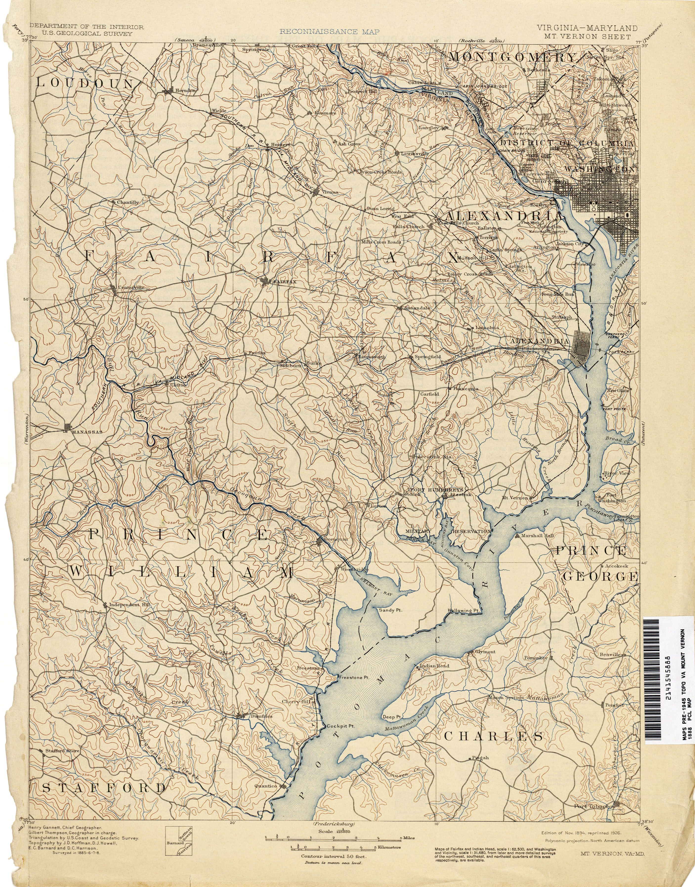
- 1894 topographic map of the city of Alexandria, Alexandria County, Falls Church and eastern Fairfax County, showing the route of the Washington, Alexandria and Mount Vernon Railway (not labled) between the city of Alexandria and Mount Vernon: Gannett, Henry; Thompson, Gilbert (November 1894). "Reconnaissance Map: Virginia - Maryland: Mt. Vernon Sheet". United States Department of the Interior: United States Geological Survey. Retrieved January 20, 2020 – via Virginia Historical Topographic Maps, Perry–Castañeda Library Map Collection, Perry–Castañeda Library, University of Texas at Austin, Austin, Texas.
- 1894 topographic map of the city of Alexandria, Alexandria County, Falls Church and northeastern Fairfax County, showing the route of the Washington, Alexandria and Mount Vernon Railway in the city of Alexandria and Fairfax County: "The Vicinity of Washington, D.C.: Entered according to Act of Congress, in the year 1894". Philadelphia: Griffith M. Hopkins, C.E. LCCN 88693364. OCLC 18019645. Retrieved January 20, 2020 – via Library of Congress.
- 1898 topographic map of Washington, D.C., the city of Alexandria, Alexandria County (now Arlington County), Falls Church and northeastern Fairfax County, showing the routes of the Washington, Arlington & Falls Church Electric Railroad (W.A. & F.C. E.R.R.) and the Washington, Alexandria & Mt. Vernon Electric Railway (W. A. & MT. V. Electric R.R.): "Washington and Vicinity". Washington, D.C.: United States Department of the Interior: United States Geological Survey. 1898. Retrieved July 24, 2020 – via University of Alabama Map Library.
- 1900 map of Alexandria County (now Arlington County), showing the routes of the Washington, Arlington & Falls Church Electric Railway and the Washington, Alexandria & Mt. Vernon Electric Railway: "Map of Alexandria County, Virginia for the Virginia Title Co". Alexandria, Virginia: The Company. 1900. LCCN 89692758. OCLC 20854681. Retrieved October 7, 2019 – via Library of Congress website.
- November 1901 topographic map of the District of Columbia and northeastern Alexandria County (now Arlington County), showing the routes of the Washington, Arlington & Falls Church Railroad (not labeled) and the Washington, Alexandria & Mt. Vernon Electric Railroad (Wash. Alex. & Mt. Vernon Electric R.R.): Outhet, R. A. (November 1901). "Map of the District of Columbia Showing Areas Recommended to be Taken as Necessary for New Parks and Park Connections". Washington, D.C.: Commission on the Improvement of the Park System. LCCN 87694473. OCLC 16869886. Retrieved January 29, 2020 – via Library of Congress website.
- 1904 map of Alexandria County (now Arlington County), the city of Alexandria and northeastern Fairfax County showing the routes of the Washington, Arlington & Falls Church Railroad (W. A & F.C. R.R.) and the Washington, Alexandria & Mt. Vernon Railroad (Wash. Alex. & Mt.V. R.R.): "Map of electric railroads,steam railroads and streets in Washington and vicinity". Rand McNally & Co.'s Pictorial Guide to Washington. New York and Chicago: Rand McNally & Company. 1904. p. 5. Retrieved January 13, 2013 – via Internet Archive.
- 1907 map of Alexandria County (now Arlington County) showing the routes of the Washington, Arlington & Falls Church Railway (W.A.&FC RY) and the Washington & Mt. Vernon Railway (WA. & MT. V RY): Reynolds, Charles A. (1907). "Map of Arlington and vicinity". Washington: The Nation's Capital. New York: Foster & Reynolds. p. 141. Retrieved January 13, 2013 – via Internet Archive.

- Circa 1907 map of Alexandria County, Virginia (now Arlington County), showing the routes of the Washington, Alexandria and the Mt. Vernon Railway (W. A. & Mt V. RY.) and the Washington, Arlington & Falls Church Railway (W. A. & F. C. RY.): Noetzel, Gregor; Boteler, G. G. (1907). "Map of Alexandria County, Virginia: formerly part of the District of Columbia". Washington, D.C.: G.G. Boteler. LCCN 89692766. OCLC 20854717. Retrieved October 8, 2019 – via Library of Congress website.
- Washington—Virginia Railway system map (c. 1915). Washington—Virginia Railway Company (publisher). In "Figure 18: A map of the electric train line" (PDF). South Railroad Street Park Master Plan: General Management Plan and Conceptual Development Plan. Fairfax County Park Authority. September 27, 2006. p. 19. Archived from the original (PDF) on October 7, 2019. Retrieved January 20, 2020.
- 1915 topographic map of northwestern Fairfax County, showing the route of the Fairfax line of the Washington—Virginia Railway (Electric RR) between Vienna and the city of Fairfax and the routes of the Washington and Old Dominion Railway between Vienna and Herndon and between Difficult Run and Great Falls: Marshall, R. B.; Sutton, Frank (October 1915). "Topography: Virginia: Fairfax Quadrangle". Washington, D.C.: United States Department of the Interior: United States Geological Survey. Retrieved July 25, 2020 – via Historic Prince William.Archived July 25, 2020, at the Wayback Machine
- 1915 topographic map of Washington, D.C., the city of Alexandria, Alexandria County, Falls Church and northeastern Fairfax County, showing the routes of the Washington—Virginia Railway and the Washington and Old Dominion Railway: Marshall, R. B.; Sutton, Frank (1915). "Topography: Maryland — District of Columbia — Virginia, Washington and vicinity". Washington, D.C.: United States Department of the Interior: United States Geological Survey. LCCN 87691472. Retrieved July 24, 2020 – via Library of Congress.
- 1917 topographic map of Washington, D.C., the city of Alexandria, Alexandria County, Falls Church and northeastern Fairfax County, showing the routes the routes of the Washington—Virginia Railway and the Washington and Old Dominion Railway: Marshall, R. B.; Sutton, Frank (1917). "Washington and Vicinity: Maryland: District of Columbia: Virginia". Washington, D.C.: United States Department of the Interior: United States Geological Survey. LCCN 87691475. OCLC 15519039. Retrieved July 24, 2020 – via Library of Congress.
- 1924 topographic map of the city of Alexandria and southeastern Fairfax County showing the Washington-Virginia Railway's route between Alexandria and Mount Vernon: "Virginia-Maryland: Fort Humphreys and Vicinity". United States Department of the Interior: United States Geological Survey. 1924. Retrieved February 12, 2010 – via University of Alabama website.
- 1925 topographic map of south-central Maryland and southeastern Fairfax County showing the Washington—Virginia Railway's route in Fairfax County to Mt. Vernon: "State of Maryland Geological Survey: Maryland - Virginia: Indian Head Quadrangle". United States Department of the Interior: United States Geological Survey. 1925. Retrieved January 23, 2020 – via Virginia Historical Topographic Maps, Perry–Castañeda Library Map Collection, Perry–Castañeda Library, University of Texas at Austin, Austin, Texas.
- 1929 topographic map of Washington, D.C., the city of Alexandria, Alexandria County, Falls Church and northeastern Fairfax County, showing the routes of the Arlington and Fairfax (A & F) Railway, the Mount Vernon, Alexandria and Washington (Mt V A and W) Railway and the Washington and Old Dominion Railway: "Washington and Vicinity: Maryland: District of Columbia: Virginia". Washington, D.C.: United States Department of the Interior: United States Geological Survey. 1929. LCCN 87693006. OCLC 15653164. Retrieved July 24, 2020 – via Library of Congress.
See also
- Washington streetcars
- Washington Metro
- Urban rail transit
- Bustitution
- Trolley park
Notes
- (1) Washington—Virginia Railway system map (c. 1915). Washington—Virginia Railway Company (publisher). In "Figure 18: A map of the electric train line" (PDF). South Railroad Street Park Master Plan: General Management Plan and Conceptual Development Plan. Fairfax County Park Authority. September 27, 2006. p. 19. Archived from the original (PDF) on October 7, 2019. Retrieved October 7, 2019.
(2) "Map of electric railroads,steam railroads and streets in Washington and vicinity". Rand McNally & Co.'s Pictorial Guide to Washington. New York and Chicago: Rand McNally & Company. 1904. p. 5. Retrieved January 13, 2013 – via Internet Archive.
(3) Reynolds, Charles A. (1907). "Map of Arlington and vicinity". Washington: The Nation's Capital. New York: Foster & Reynolds. p. 141. Retrieved January 13, 2013 – via Internet Archive.
(4) 1900 map of Alexandria County, Virginia (now Arlington County), showing the routes of the Washington, Arlington & Falls Church Railway and the Washington, Alexandria & Mt. Vernon Electric Railway: "Map of Alexandria County, Virginia for the Virginia Title Co". Alexandria, Virginia: The Company. 1900. Retrieved October 7, 2019 – via Library of Congress website.
(5) Circa 1907 map of Alexandria County, Virginia (now Arlington County), showing the routes of the Washington, Alexandria and the Mt. Vernon Railway (W. A. & Mt V. Ry.) and the Washington, Arlington & Falls Church Railway (W. A. & F. C. Ry.): Noetzel, Gregor; Boteler, G. G. (1907). "Map of Alexandria County, Virginia: formerly part of the District of Columbia". Washington, D.C.: G.G. Boteler. Retrieved October 8, 2019 – via Library of Congress website.(6) 1938 Alexander Gross street and rail map of Arlington and vicinity in J. A. Weyraugh Document Collection in website of Washington & Old Dominion Railroad Yahoo group Accessed April 24, 2009. - (1) 1900 map of Alexandria County, Virginia (now Arlington County), showing the routes of the Washington, Alexandria & Mt. Vernon Electric Railway near Arlington Junction: "Map of Alexandria County, Virginia for the Virginia Title Co". Alexandria, Virginia: The Company. 1900. Retrieved October 7, 2019 – via Library of Congress website.
(2) Circa 1907 map of Alexandria County, Virginia (now Arlington County), showing the routes of the Washington, Alexandria and the Mt. Vernon Railway (W. A. & Mt V. Ry.) and the Washington, Alexandria and Mt. Vernon Railway (W. A. & Mt V. Ry.) near Arlington Junction: Noetzel, Gregor; Boteler, G. G. (1907). "Map of Alexandria County, Virginia: formerly part of the District of Columbia". Washington, D.C.: G.G. Boteler. Retrieved October 8, 2019 – via Library of Congress website. - Tindall, Dr. William (1918). "Beginning of Street Railways in the National Capital". Records of the Columbia Historical Society, Washington, D.C. Washington, D.C.: Columbia Historical Society. 21: 46–47. Retrieved February 2, 2014 – via Google Books..
- Through the Most Historic Section of Virginia: Quickest, Most Convenient and Interesting Route to Mt. Vernon, Alexandria, Arlington .. National Cemetery .. via the Washington, Arlington & Mt. Vernon Railway. Advertisement in "Industrial and Historical Sketch of Fairfax County, Virginia". Fairfax County Board of Supervisors. 1907. p. 90. Archived from the original on June 10, 2016. Retrieved February 2, 2014 – via Google Books..
- Snowden, William H. (1902). Washington City to Mount Vernon: Stations And Distances. Some Old Historic Landmarks of Virginia and Maryland, Described in a Hand-book for the Tourist Over the Washington, Alexandria and Mount Vernon Electric Railway (3rd ed.). Alexandria, Virginia: G.H. Ramey & Son. p. 5. OCLC 6234650. Retrieved February 2, 2020 – via Internet Archive..
- Washington-Virginia Railway Co. timetable in Victorian Society at Falls Church (2007). "6. An Era Ends: 1901-1915". Images of America: Victorian Falls Church. Charleston SC, Chicago IL, Portsmouth NH, San Francisco CA: Arcadia Publishing. p. 102. ISBN 978-0-7385-5250-7. Archived from the original on May 9, 2016. Retrieved September 24, 2016 – via Google Books..
- William H. Rehnquist, William H. (April 27, 2001). "Remarks at the Arlington Historical Society Banquet". United States Supreme Court. Archived from the original on February 3, 2014. Retrieved February 3, 2014.
- Cohen, Robert (2003). "History of the Long Railroad Bridge Crossing Across the Potomac River". Washington, D.C. Chapter: National Railway Historical Society. Archived from the original on February 3, 2014. Retrieved February 3, 2014.
- ""Transportation" marker". HMdb.org: The Historical Marker Database. September 15, 2009. Archived from the original on September 23, 2015. Retrieved February 5, 2012.
Near this point the Alexandria Canal crossed Four Mile Run, connecting Alexandria docks and railyards to Georgetown and western Maryland from 1843 to 1886. To the east were the turnpike and railroad. In 1896 the Washington, Alexandria and Mount Vernon Railway began to run electric trolleys beside the abandoned canal in this area, where it also built a car barn, repair shops and a power house. In 1906 the trolley line opened and operated Luna Park west of the tracks, providing a ballroom, roller coaster, water slide and other amusements. Parts of this complex survived until 1993, when the trolley barn was torn down after serving as a bus garage since the 1930s. Eads Street traces the canal and trolley line.
- 1900 map of Alexandria County, Virginia (now Arlington County) showing the route of the "Washington, Alexandria & Mt. Vernon Electric R. W." within the route of the "Old Alexandria Canal" northeast of Four Mile Run and west of the Alfred Richards Brick Co. and the Morrison Brick Co.: "Map of Alexandria County, Virginia for the Virginia Title Co". Alexandria, Virginia: The Company. 1900. Retrieved October 7, 2019 – via Library of Congress website.
- (1) Ness, Leland (2008). "The Electric Railway historical marker" (PDF). Del Ray and the Town of Potomac: Del Ray Interpretive Signs. City of Alexandria, Virginia. Archived from the original (PDF) on September 16, 2015. Retrieved January 23, 2016.
(2) Stone, Jim. "The Washington & Old Dominion Railroad in Del Ray". Alexandria, VA: Del Ray Citizens Association. Archived from the original on March 29, 2008. Retrieved January 17, 2010. - "History of New Alexandria". Welcome to New Alexandria, Virginia. Retrieved February 2, 2020. Archived October 8, 2014, at the Wayback Machine
- Snowden, William H. (1902). Some Old Historic Landmarks of Virginia and Maryland, Described in a Hand-book for the Tourist Over the Washington, Alexandria and Mount Vernon Electric Railway (3rd ed.). Alexandria, Virginia: G.H. Ramey & Son. p. 1. OCLC 6234650. Retrieved February 2, 2018 – via Internet Archive.
- Washington-Virginia Railway: Geographical List of Railway Stations in Arlington County. The Arlington County Directory and Year Book. Rosslyn, Virginia: The Colonial Printery. 1924. p. 50. LCCN 25001549.
- Locations of stations in 2008, from comparison of contemporary and 2008 street maps
- Mannarino, Tammy (January 9, 2019). "Wellington, Riverview, Andalusia, Arcturus and Collingwood: The Snowden Brothers and their Homes". Backyard Mount Vernon. Archived from the original on July 23, 2019. Retrieved February 12, 2020 – via WordPress.
- 1900 map of Alexandria County, Virginia (now Arlington County, Virginia), showing the Braddock Station of the Washington, Alexandria and Mt. Vernon Railway: "Map of Alexandria County, Virginia for the Virginia Title Co". Alexandria, Virginia: The Company. 1900. Retrieved October 7, 2019 – via Library of Congress website.
- Image of "The Electric Railway" historical marker near site of Mount Ida station in Ness, Leland (2008). "The Electric Railway historical marker" (PDF). Del Ray and the Town of Potomac: Del Ray Interpretive Signs. City of Alexandria, Virginia. Archived from the original (PDF) on September 16, 2015. Retrieved January 23, 2016.
- "Electric Railway" historical marker near site of Mount Ida station (location and partial text of marker) in alsdmf (May 19, 2010). "Del Ray Interpretive Markers". Archived from the original on April 7, 2014. Retrieved May 23, 2011.
- Image of "St. Asaph Racetrack" historical marker near site of St. Asaph station in Ness, Leland (2008). "St. Asaph Racetrack historical marker" (PDF). Del Ray and the Town of Potomac: Del Ray Interpretive Signs. City of Alexandria, Virginia. Archived from the original (PDF) on September 19, 2015. Retrieved January 23, 2016.
- "St. Asaph Racetrack" historical marker near site of St. Asaph station (location and partial text of marker) in alsdmf (May 19, 2010). "Del Ray Interpretive Markers". Archived from the original on April 7, 2014. Retrieved May 23, 2011.
- Image of "Mount Vernon Avenue" historical marker near site of Hume station in Ness, Leland (2008). "Mount Vernon Avenue" (PDF). Del Ray and the Town of Potomac: Del Ray Interpretive Signs. City of Alexandria, Virginia. Archived from the original (PDF) on October 1, 2015. Retrieved May 23, 2011.
- "Mount Vernon Avenue" historical marker near site of Hume station (location and partial text of marker) in alsdmf (May 19, 2010). "Del Ray Interpretive Markers". Archived from the original on April 7, 2014. Retrieved May 23, 2011.
- 1900 map of Alexandria County, Virginia (now Arlington County), showing St. Elmo Station: "Map of Alexandria County, Virginia for the Virginia Title Co". Alexandria, Virginia: The Company. 1900. Retrieved October 7, 2019 – via Library of Congress website.
- Image of "The Bluemont Line" historical marker near site of St. Elmo station in Ness, Leland (2008). "The Bluemont Line historical marker" (PDF). Del Ray and the Town of Potomac: Del Ray Interpretive Signs. City of Alexandria, Virginia. Archived from the original (PDF) on December 25, 2015. Retrieved May 23, 2011.
- "Bluemont Line" historical marker near site of St. Elmo station (location and partial text of marker) in alsdmf (May 19, 2010). "Del Ray Interpretive Markers". Archived from the original on April 7, 2014. Retrieved May 23, 2011.
- Coordinates of "Transportation" historical marker: 38°50′34″N 77°03′16″W
- Circa 1907 map of Alexandria County, Virginia (now Arlington County), showing the Luna Park station of the Washington, Alexandria and Mt. Vernon Railway (W. A. & Mt V. Ry.): Noetzel, Gregor; Boteler, G. G. (1907). "Map of Alexandria County, Virginia: formerly part of the District of Columbia". Washington, D.C.: G.G. Boteler. Retrieved October 8, 2019 – via Library of Congress website.
- 1900 map of Alexandria County, Virginia (now Arlington County, Virginia), showing Addison Station: "Map of Alexandria County, Virginia for the Virginia Title Co". Alexandria, Virginia: The Company. 1900. Retrieved October 7, 2019 – via Library of Congress website.
- (1) 1900 map of Alexandria County, Virginia (now Arlington County), showing Arlington Junction: "Map of Alexandria County, Virginia for the Virginia Title Co". Alexandria, Virginia: The Company. 1900. Retrieved October 7, 2019 – via Library of Congress website.
(2) Circa 1907 map of Alexandria County, Virginia (now Arlington County), showing Arlington Junction: Noetzel, Gregor; Boteler, G. G. (1907). "Map of Alexandria County, Virginia: formerly part of the District of Columbia". Washington, D.C.: G.G. Boteler. Retrieved October 8, 2019 – via Library of Congress website. - Cullum, James (May 15, 2020). "Historic Streetcar Tracks Found During Water Main Repair in Old Town". ALX Now. Retrieved June 16, 2020.
- (1) 1900 map of Alexandria County, Virginia (now Arlington County) showing the route of the Washington Alexandria and Mt. Vernon R. W. on the southeast side of the Georgetown & Alexandria Road within the "Arlington Reservation", between the Potomac River and the "National Cemetery": "Map of Alexandria County, Virginia for the Virginia Title Co". Alexandria, Virginia: The Company. 1900. Retrieved October 7, 2019 – via Library of Congress website.
(2) Circa 1907 map of Alexandria County, Virginia (now Arlington County), showing the route of the Washington, Alexandria and the Mt. Vernon Railway (W. A. & Mt V. Ry.) on the southeast side of a road within the "Arlington Reservation", between the Potomac River and the "Nat'l. Cemetery": Noetzel, Gregor; Boteler, G. G. (1907). "Map of Alexandria County, Virginia: formerly part of the District of Columbia". Washington, D.C.: G.G. Boteler. Retrieved October 8, 2019 – via Library of Congress website. - 1900 map of Alexandria County, Virginia (now Arlington County), showing the "Rosslynn" station of the Washington, Arlington & Falls Church Railway and the Washington, Alexandria & Mt. Vernon Electric Railway near the Aqueduct Bridge: "Map of Alexandria County, Virginia for the Virginia Title Co". Alexandria, Virginia: The Company. 1900. Retrieved October 7, 2019 – via Library of Congress website.
- 1925 photo of Rosslyn Archived February 8, 2005, at the Wayback Machine. Accessed March 12, 2008. From "Washington, D.C., Past and Present", Oneonta Press website, Peter R. Penczer, Arlington, VA Archived February 7, 2005, at the Wayback Machine. Accessed March 12, 2008.
- 1900 map of Alexandria County, Virginia (now Arlington County, Virginia), showing the Arlington station of the Washington, Alexandria & Mt. Vernon Electric Railway: "Map of Alexandria County, Virginia for the Virginia Title Co". Alexandria, Virginia: The Company. 1900. Retrieved October 7, 2019 – via Library of Congress website.
- Office of the Depot Quartermaster General (August 14, 1912). "Enlargeable map of Arlington National Cemetery showing original location of Sheridan Gate and Arlington station (lower right)". Archived from the original on December 30, 2015. Retrieved December 30, 2015. At Schara, Mark (2012). "Map - Arlington National Cemetery, Sheridan Gate, Arlington, Arlington County, VA". Washington, D.C.: Library of Congress Prints and Photographs Division. Archived from the original on December 30, 2015. Retrieved December 30, 2015.
- (1) 1900 map of Alexandria County, Virginia (now Arlington County), showing the route of the Washington, Alexandria & Mt. Vernon Electric Railway near Queen City station: "Map of Alexandria County, Virginia for the Virginia Title Co". Alexandria, Virginia: The Company. 1900. Retrieved October 7, 2019 – via Library of Congress website.
(2) Circa 1907 map of Alexandria County, Virginia (now Arlington County) showing the route of the Washington, Alexandria and Mt. Vernon Railway (W. A. & Mt V. Ry.) near Queen City station: Noetzel, Gregor; Boteler, G. G. (1907). "Map of Alexandria County, Virginia: formerly part of the District of Columbia". Washington, D.C.: G.G. Boteler. Retrieved October 8, 2019 – via Library of Congress website. - "Washington and Arlington Railway Company". Laws Relating to Street-Railway Franchises in the District of Columbia. Washington, D.C.: Government Printing Office. 1896. pp. 157–164. Retrieved January 31, 2014 – via Internet Archive..
- Washington, Arlington and Falls Church Ry. "Advertisement in "Industrial and Historical Sketch of Fairfax County, Virginia". Fairfax County Board of Supervisors. 1907. p. 88. Archived from the original on April 10, 2017. Retrieved February 2, 2014 – via Google Books.
- "Closing of Highway at Bridge Planned". The Washington Post. September 19, 1931.
- "Evans Autorailer No. 107, Destination: Vienna". Friends of the W&OD Trail. Archived from the original (photograph) on September 21, 2015. Retrieved November 10, 2018.
- 1900 map of Alexandria County, Virginia (now Arlington County), showing the route of the "Washington Arlington & Falls Church Electric R. W." between Rosslyn and Nauck: (1) "Map of Alexandria County, Virginia for the Virginia Title Co". Alexandria, Virginia: The Company. 1900. Retrieved October 7, 2019 – via Library of Congress website.
(2) Circa 1907 map of Alexandria County, Virginia (now Arlington County), showing the route of the Washington, Arlington and Falls Church Railway (W. A. & F. C. Ry.) between Rosslyn and Nauck: Noetzel, Gregor; Boteler, G. G. (1907). "Map of Alexandria County, Virginia: formerly part of the District of Columbia". Washington, D.C.: G.G. Boteler. Retrieved October 8, 2019 – via Library of Congress website. - (1) 1900 map of Alexandria County, Virginia (now Arlington County), showing the route of the "Washington Arlington & Falls Church Electric R. W." near Nauck: "Map of Alexandria County, Virginia for the Virginia Title Co". Alexandria, Virginia: The Company. 1900. Retrieved October 7, 2019 – via Library of Congress website.
(2) Circa 1907 map of Alexandria County, Virginia (now Arlington County), showing the route of the Washington, Arlington and Falls Church Railway (W. A. & F. C. Ry.) near Nauck: Noetzel, Gregor; Boteler, G. G. (1907). "Map of Alexandria County, Virginia: formerly part of the District of Columbia". Washington, D.C.: G.G. Boteler. Retrieved October 8, 2019 – via Library of Congress website. - 1917 topographic map of Washington and vicinity showing the Washington-Virginia Railway within the Radnor Heights area: Marshall, R. B.; Sutton, Frank (1917). "Washington and Vicinity". United States Geological Survey. LCCN 87691474. OCLC 15519038. Retrieved January 22, 2020 – via Library of Congress website.
- 1900 map of Alexandria County, Virginia (now Arlington County), showing the Myer Steps station of the Washington, Arlington & Falls Church Railway: "Map of Alexandria County, Virginia for the Virginia Title Co". Alexandria, Virginia: The Company. 1900. Retrieved October 7, 2019 – via Library of Congress website.
- 1900 map of Alexandria County, Virginia (now Arlington County), showing the Arlington station of the Washington, Arlington & Falls Church Railway: "Map of Alexandria County, Virginia for the Virginia Title Co". Alexandria, Virginia: The Company. 1900. Retrieved October 7, 2019 – via Library of Congress website.
- 1917 topographic map of Washington and vicinity showing two routes of the Washington—Virginia Railway crossing at Hatfield: Marshall, R. B.; Sutton, Frank (1917). "Washington and Vicinity". United States Geological Survey. LCCN 87691474. OCLC 15519038. Retrieved January 22, 2020 – via Library of Congress website.
- 1900 map of Alexandria County, Virginia (now Arlington County), showing the Penrose station of the Washington, Arlington & Falls Church Railway: "Map of Alexandria County, Virginia for the Virginia Title Co". Alexandria, Virginia: The Company. 1900. Retrieved October 7, 2019 – via Library of Congress website.
- 1900 map of Alexandria County, Virginia (now Arlington County), showing the route of the Washington, Arlington & Falls Church Railway adjacent to the property of Miles C. Munson: "Map of Alexandria County, Virginia for the Virginia Title Co". Alexandria, Virginia: The Company. 1900. Retrieved October 7, 2019 – via Library of Congress website.
- 1900 map of Alexandria County, Virginia (now Arlington County), showing the route of the Washington, Arlington & Falls Church Railway within and adjacent to the property of Miles C. Munson: "Map of Alexandria County, Virginia for the Virginia Title Co". Alexandria, Virginia: The Company. 1900. Retrieved October 7, 2019 – via Library of Congress website.
- 1900 map of Alexandria County, Virginia (now Arlington County), showing the Columbia station of the Washington, Arlington & Falls Church Railway: "Map of Alexandria County, Virginia for the Virginia Title Co". Alexandria, Virginia: The Company. 1900. Retrieved October 7, 2019 – via Library of Congress website.
- 1900 map of Alexandria County, Virginia (now Arlington County), showing the route of the Washington, Arlington & Falls Church Railway adjacent to the property of Henry S. Petty: "Map of Alexandria County, Virginia for the Virginia Title Co". Alexandria, Virginia: The Company. 1900. Retrieved October 7, 2019 – via Library of Congress website.
- (1) 1900 map of Alexandria County, Virginia (now Arlington County), showing the route of the Washington, Arlington & Falls Church Railway adjacent to the property of Fox: "Map of Alexandria County, Virginia for the Virginia Title Co". Alexandria, Virginia: The Company. 1900. Retrieved October 7, 2019 – via Library of Congress website.(2) 1917 topographic map of Washington and vicinity showing the Fox station on the Washington-Virginia Railway: Marshall, R. B.; Sutton, Frank (1917). "Washington and Vicinity". United States Geological Survey. LCCN 87691474. OCLC 15519038. Retrieved January 22, 2020 – via Library of Congress website.
- 1917 topographic map of Washington and vicinity showing Fort Berry near the Washington-Virginia Railway: Marshall, R. B.; Sutton, Frank (1917). "Washington and Vicinity". United States Geological Survey. LCCN 87691474. OCLC 15519038. Retrieved January 22, 2020 – via Library of Congress website.
- 1900 map of Alexandria County, Virginia (now Arlington County), showing the Nauck station on the Washington, Arlington & Falls Church Railway west of the property of S.B. Corbett: "Map of Alexandria County, Virginia for the Virginia Title Co". Alexandria, Virginia: The Company. 1900. Retrieved October 7, 2019 – via Library of Congress website.
- Northern Virginia Regional Park Authority. ""Nauck: A Neighborhood History" marker". HMdb.org: The Historical Marker Database. Archived from the original on December 29, 2018. Retrieved February 5, 2012.
..... It was the electric railway, which came to Nauck in 1898 that spurred development of the neighborhood. The Nauck line of the Washington, Arlington, and Fairfax Railway ran parallel to what is now South Kenmore Street and there was a station located south of what is now the intersection of 19th Street South and South Kenmore Street. ......
Marker is at the trailhead of the Washington & Old Dominion Railroad Trail at S. Shirlington Road near S. Four Mile Run Dr. - 1917 topographic map of Washington and vicinity showing the Nauck station on the Washington-Virginia Railway: Marshall, R. B.; Sutton, Frank (1917). "Washington and Vicinity". United States Geological Survey. LCCN 87691474. OCLC 15519038. Retrieved January 22, 2020 – via Library of Congress website.
- 1917 topographic map of Washington and vicinity showing the Green Valley station on the Washington-Virginia Railway: Marshall, R. B.; Sutton, Frank (1917). "Washington and Vicinity". United States Geological Survey. LCCN 87691474. OCLC 15519038. Retrieved January 22, 2020 – via Library of Congress website.
- (1) The Fairfax County Courthouse: A Brief History (Official Fairfax County government site) Archived November 30, 2007, at the Wayback Machine Accessed Jan. 15, 2008
(2) Photograph of Historic Fairfax County Courthouse by George Petropol, Manassas, Virginia Archived February 29, 2008, at the Wayback Machine Accessed Jan. 15, 2008 - ""Arlington-Fairfax Electric Railway" marker". HMdb.org: The Historical Marker Database. Archived from the original on November 5, 2015. Retrieved October 18, 2016.
The Arlington-Fairfax Line connected Fairfax with Washington D.C. from 1904-1939 and briefly terminated near this location until 1908 when it was extended to the courthouse after the original station was destroyed by fire. The new stop served both as a passenger station and a stop for tourists to visit historic sites. A freight depot replaced the station near this location spawning a small commercial center, the remnants of which remained until 2009. A bedroom community grew along Cedar Avenue where the trolley made a stop after leaving this location. .... Marker is in Fairfax, Virginia. Marker is at the intersection of Main Street (Virginia Route 236) and Railroad Avenue, on the right when traveling east on Main Street.
- Johnson, II, William Page (Fall 2003). "The Fairfax Electric Depot & Mill Managers Home" (PDF). The Fare Facs Gazette: The Newsletter of Historic Fairfax City, Inc., Vol. 1, Issue 4. Archived from the original (PDF) on July 26, 2011. Retrieved November 12, 2016.
- Stuntz, pp. 245,246,264
- Photographs of unpaved trails and trolley cut in Figures 14 (Walking along the trail) and 20 (The trolley cut showing erosion and a path with a 15’ – 20’ depth) in "South Railroad Street Park Master Plan: General Management Plan and Conceptual Development Plan" (PDF). Fairfax County Park Authority. September 27, 2006. pp. 16, 21. Archived from the original (PDF) on October 7, 2019. Retrieved October 7, 2019.
- (1) 1900 map of Alexandria County, Virginia (now Arlington County), showing the route of the "Washington Arlington & Falls Church Electric R. W." between Falls Church and Ballston: "Map of Alexandria County, Virginia for the Virginia Title Co". Alexandria, Virginia: The Company. 1900. Retrieved October 7, 2019 – via Library of Congress website.
(2) Circa 1907 map of Alexandria County, Virginia (now Arlington County), showing the route of the Washington, Arlington and Falls Church Railway (W. A. & F. C. Ry.) between Falls Church and Ballston: Noetzel, Gregor; Boteler, G. G. (1907). "Map of Alexandria County, Virginia: formerly part of the District of Columbia". Washington, D.C.: G.G. Boteler. Retrieved October 8, 2019 – via Library of Congress website. - ""Lacey Car Barn" marker". HMdb.org: The Historical Marker Database. Archived from the original on July 2, 2017. Retrieved July 2, 2017.
In 1896, the Washington, Arlington & Falls Church Railway began running electric trolleys from Rosslyn to Falls Church on the present routes of Fairfax Drive and I-66. By 1907, the line linked downtown Washington to Ballston, Vienna, and the Town of Fairfax. In 1910, the railway built at this location a car barn, rail yard, workshop, electrical substation, and general office. In 1912, the rival Washington & Old Dominion Railway began crossing the tracks on a bridge 200 yards west of here, traveling the present route of I-66 from Rosslyn. The line to Fairfax closed in 1939, but Metrorail’s Orange Line follows its route through Arlington. ..... Marker is in Arlington, Virginia, in Arlington County. Marker is at the intersection of Fairfax Drive and Glebe Road (Virginia Route 120), on the right when traveling west on Fairfax Drive.
- (1) 1900 map of Alexandria County, Virginia (now Arlington County), showing the route of the "Washington Arlington & Falls Church Electric R. W." between Ballston and Clarendon: "Map of Alexandria County, Virginia for the Virginia Title Co". Alexandria, Virginia: The Company. 1900. Retrieved October 7, 2019 – via Library of Congress website.
(2) Circa 1907 map of Alexandria County, Virginia (now Arlington County), showing the route of the Washington, Arlington and Falls Church Railway (W. A. & F. C. Ry.) between Ballston and Clarendon: Noetzel, Gregor; Boteler, G. G. (1907). "Map of Alexandria County, Virginia: formerly part of the District of Columbia". Washington, D.C.: G.G. Boteler. Retrieved October 8, 2019 – via Library of Congress website. - (1) 1900 map of Alexandria County, Virginia (now Arlington County), showing the route of the "Washington Arlington & Falls Church Electric R. W." between Clarendon and Rosslyn: "Map of Alexandria County, Virginia for the Virginia Title Co". Alexandria, Virginia: The Company. 1900. Retrieved October 7, 2019 – via Library of Congress website.
(2) Circa 1907 map of Alexandria County, Virginia (now Arlington County), showing the route of the Washington, Arlington & Falls Church Railway (W. A. & F. C. Ry.) between Clarendon and Rosslyn: Noetzel, Gregor; Boteler, G. G. (1907). "Map of Alexandria County, Virginia: formerly part of the District of Columbia". Washington, D.C.: G.G. Boteler. Retrieved October 8, 2019 – via Library of Congress website. - (1) Trompeter, Brian (July 22, 2011). "Owner Offers Conservation Easement for Former Trolley Station in Oakton". Sun Gazette. Retrieved February 1, 2012.
(2) "NVCT Preserves the Historic Oakton Trolley Station". Northern Virginia Conservation Trust. July 14, 2011. Archived from the original on August 23, 2011. Retrieved February 1, 2012.
(3) "Oakton Historic Trolley Line Preserved" (PDF). Connection. Connection Newspapers. August 17, 2011. p. 4. Archived (PDF) from the original on March 4, 2016. Retrieved January 13, 2012. - (1) "Virginia SP Oakton Trolley Station". National Archives Catalog. National Archives and Records Administration. Archived from the original on January 27, 2020. Retrieved January 27, 2020.
(2) "Oakton Trolley Station: National Register Information System ID: 95000026". NPGallery Digital Asset Management System. United States Department of the Interior: National Park Service. Retrieved January 28, 2020.
(3) "Oakton Trolley Station". Virginia-Fairfax County. National Register of Historic Places. Archived from the original on September 6, 2015. Retrieved January 13, 2012.
(4) "Weekly List of Actions Taken on Properties (National Register of Historic Places): 2/06/95 through 2/10/95" (PDF). Washington, D.C.: National Park Service, United States Department of the Interior. February 17, 1995. Archived from the original (PDF) on December 28, 2019. Retrieved January 27, 2020.
(5) Stefan, Adrienne; Macklin, Tom (July 11, 1994). "Oakton Trolley Station" (PDF). United States Department of the Interior: National Park Service: National Register of Historic Places Registration Form. Richmond, Virginia: Virginia Department of Historic Resources. Archived from the original (pdf) on February 18, 2018. Retrieved February 1, 2012. and Accompanying photo - Undated photo of Vienna station of Washington-Virginia Railway, Vienna, Virginia Archived March 4, 2016, at the Wayback Machine. Accessed March 12, 2008. From McCray, P., Washington & Old Dominion Railroad: 1847 to 1968. A Photographic History. Accessed March 12, 2008.
- Guillaudeu, David A.; Foreword by McCray, Paul E. (2013). Washington & Old Dominion Railroad. Images of Rail. Charleston, South Carolina: Arcadia Publishing. p. 37. ISBN 9780738597928. OCLC 811603181. Retrieved October 31, 2018 – via Pinterest.
- Taylor, Cathy. "Undated photo of Washington-Virginia Railway Co. station at Shephard House, at 1101 West Broad Street, on the West End". Images of America: Historic Falls Church. Charleston, South Carolina: Arcadia Publishing. p. 56. ISBN 9780738592626. OCLC 792878886 – via Google Books.
Shephard House, at 1101 West Broad Street, served as both a station and stationmaster's residence on the West End. By 1903, real estate agents, subdivision developers, and potential residents of Falls Church were using the trolley services extensively, seeing development and promotional opportunities with the service providing flexible access to previously remote locales.
. - (1) 1900 map of Alexandria County, Virginia (now Arlington County), showing the East Falls Church station of the Washington, Arlington & Falls Church Electric Railway: "Map of Alexandria County, Virginia for the Virginia Title Co". Alexandria, Virginia: The Company. 1900. Retrieved October 7, 2019 – via Library of Congress website.
(2) Circa 1907 map of Alexandria County, Virginia (now Arlington County), showing the unnamed East Falls Church station of the Washington, Arlington and Falls Church Railway (W. A. & F. C. Ry.): Noetzel, Gregor; Boteler, G. G. (1907). "Map of Alexandria County, Virginia: formerly part of the District of Columbia". Washington, D.C.: G.G. Boteler. Retrieved October 8, 2019 – via Library of Congress website. - Taylor, Cathy. "Undated photo of electric railway station at Wm. B. Thompson Groceries in East Falls Church". Images of America: Historic Falls Church. Charleston, South Carolina: Arcadia Publishing. p. 55. ISBN 9780738592626. OCLC 792878886 – via Google Books.
The trains were still slow and cumbersome with the junction change at Alexandria, but electric railway tracks were laid parallel to the train tracks in town, reaching East Falls Church in 1897 and extending along Lincoln Avenue to West End by 1901. Wm. B. Thompson Groceries also housed the electric railway ticket depot and post office.
- "Undated photograph of the Washington & Old Dominion Railway and Washington-Virginia Railway stations in East Falls Church". Fairfax Underground. Archived from the original on December 29, 2019. Retrieved December 29, 2019.
- 1900 map of Alexandria County, Virginia (now Arlington County), showing the Fairfax Junction station of the Washington, Arlington & Falls Church Electric Railway: "Map of Alexandria County, Virginia for the Virginia Title Co". Alexandria, Virginia: The Company. 1900. Retrieved October 7, 2019 – via Library of Congress website.
- 1900 map of Alexandria County, Virginia (now Arlington County), showing the Washington, Arlington & Falls Church Electric Railway adjacent to property owned by I.S. Hyson: "Map of Alexandria County, Virginia for the Virginia Title Co". Alexandria, Virginia: The Company. 1900. Retrieved February 1, 2020 – via Library of Congress website.
- (1) 1900 map of Alexandria County, Virginia (now Arlington County), showing the unnamed Highland Park station of the Washington, Arlington & Falls Church Electric Railway: "Map of Alexandria County, Virginia for the Virginia Title Co". Alexandria, Virginia: The Company. 1900. Retrieved October 7, 2019 – via Library of Congress website.
(2) Circa 1907 map of Alexandria County, Virginia (now Arlington County), showing the Highland Park station of the Washington, Arlington and Falls Church Railway (W. A. & F. C. Ry.): Noetzel, Gregor; Boteler, G. G. (1907). "Map of Alexandria County, Virginia: formerly part of the District of Columbia". Washington, D.C.: G.G. Boteler. Retrieved October 8, 2019 – via Library of Congress website. - 1900 map of Alexandria County, Virginia (now Arlington County), showing the Upton station of the Washington, Arlington & Falls Church Electric Railway: "Map of Alexandria County, Virginia for the Virginia Title Co". Alexandria, Virginia: The Company. 1900. Retrieved October 7, 2019 – via Library of Congress website.
- (1) 1900 map of Alexandria County, Virginia (now Arlington County), showing the Kearney station of the Washington, Arlington & Falls Church Electric Railway: "Map of Alexandria County, Virginia for the Virginia Title Co". Alexandria, Virginia: The Company. 1900. Retrieved October 7, 2019 – via Library of Congress website.
(2) Circa 1907 map of Alexandria County, Virginia (now Arlington County), showing the Kearney station of the Washington, Arlington and Falls Church Railway (W. A. & F. C. Ry.): Noetzel, Gregor; Boteler, G. G. (1907). "Map of Alexandria County, Virginia: formerly part of the District of Columbia". Washington, D.C.: G.G. Boteler. Retrieved October 8, 2019 – via Library of Congress website. - 1900 map of Alexandria County, Virginia (now Arlington County), showing the Washington, Arlington & Falls Church Electric Railway adjacent to property owned by Blanche Kearney: "Map of Alexandria County, Virginia for the Virginia Title Co". Alexandria, Virginia: The Company. 1900. Retrieved February 1, 2020 – via Library of Congress website.
- 1900 map of Alexandria County, Virginia (now Arlington County), showing the Washington, Arlington & Falls Church Electric Railway within property owned by George A. Veitch: "Map of Alexandria County, Virginia for the Virginia Title Co". Alexandria, Virginia: The Company. 1900. Retrieved February 1, 2020 – via Library of Congress website.
- (1) 1900 map of Alexandria County, Virginia (now Arlington County), showing the Veitch Summit station of the Washington, Arlington & Falls Church Electric Railway: "Map of Alexandria County, Virginia for the Virginia Title Co". Alexandria, Virginia: The Company. 1900. Retrieved October 7, 2019 – via Library of Congress website.
(2) Circa 1907 map of Alexandria County, Virginia (now Arlington County), showing the Veitch station of the Washington, Arlington and Falls Church Railway (W. A. & F. C. Ry.): Noetzel, Gregor; Boteler, G. G. (1907). "Map of Alexandria County, Virginia: formerly part of the District of Columbia". Washington, D.C.: G.G. Boteler. Retrieved October 8, 2019 – via Library of Congress website. - 1900 map of Alexandria County, Virginia (now Arlington County), showing the Washington, Arlington & Falls Church Electric Railway adjacent to property owned by George A. Veitch: "Map of Alexandria County, Virginia for the Virginia Title Co". Alexandria, Virginia: The Company. 1900. Retrieved February 1, 2020 – via Library of Congress website.
- (1) 1900 map of Alexandria County, Virginia (now Arlington County), showing the Mulhall station of the Washington, Arlington & Falls Church Electric Railway: "Map of Alexandria County, Virginia for the Virginia Title Co". Alexandria, Virginia: The Company. 1900. Retrieved October 7, 2019 – via Library of Congress website.
(2) Circa 1907 map of Alexandria County, Virginia (now Arlington County), showing the Mulhall station of the Washington, Arlington and Falls Church Railway (W. A. & F. C. Ry.): Noetzel, Gregor; Boteler, G. G. (1907). "Map of Alexandria County, Virginia: formerly part of the District of Columbia". Washington, D.C.: G.G. Boteler. Retrieved October 8, 2019 – via Library of Congress website. - 1900 map of Alexandria County, Virginia (now Arlington County), showing the Washington, Arlington & Falls Church Electric Railway adjacent to property owned by Bertha A. Mulhall: "Map of Alexandria County, Virginia for the Virginia Title Co". Alexandria, Virginia: The Company. 1900. Retrieved February 1, 2020 – via Library of Congress website.
- (1) 1900 map of Alexandria County, Virginia (now Arlington County), showing the Sunnyside station of the Washington, Arlington & Falls Church Electric Railway: "Map of Alexandria County, Virginia for the Virginia Title Co". Alexandria, Virginia: The Company. 1900. Retrieved October 7, 2019 – via Library of Congress website.
(2) Circa 1907 map of Alexandria County, Virginia (now Arlington County), showing the Sunnyside station of the Washington, Arlington and Falls Church Railway (W. A. & F. C. Ry.): Noetzel, Gregor; Boteler, G. G. (1907). "Map of Alexandria County, Virginia: formerly part of the District of Columbia". Washington, D.C.: G.G. Boteler. Retrieved October 8, 2019 – via Library of Congress website. - 1900 map of Alexandria County, Virginia (now Arlington County), showing the Washington, Arlington & Falls Church Electric Railway within property owned by Mary S. Burch: "Map of Alexandria County, Virginia for the Virginia Title Co". Alexandria, Virginia: The Company. 1900. Retrieved February 1, 2020 – via Library of Congress website.
- Templeman, Eleanor Lee (December 13, 1958). "N. Va. Trolley Era Stirs Last Echo: Landmark Bows to Fire, Wreckers". Northern Virginia Sun.
- (1) 1900 map of Alexandria County, Virginia (now Arlington County), showing the Lacey station of the Washington, Arlington & Falls Church Electric Railway: "Map of Alexandria County, Virginia for the Virginia Title Co". Alexandria, Virginia: The Company. 1900. Retrieved October 7, 2019 – via Library of Congress website.
(2) Circa 1907 map of Alexandria County, Virginia (now Arlington County), showing the Lacey station of the Washington, Arlington and Falls Church Railway (W. A. & F. C. Ry.): Noetzel, Gregor; Boteler, G. G. (1907). "Map of Alexandria County, Virginia: formerly part of the District of Columbia". Washington, D.C.: G.G. Boteler. Retrieved October 8, 2019 – via Library of Congress website. - (1) 1900 map of Alexandria County, Virginia (now Arlington County), showing the Lacey station of the Washington, Arlington & Falls Church Electric Railway on the property of Robert S. Lacey: "Map of Alexandria County, Virginia for the Virginia Title Co". Alexandria, Virginia: The Company. 1900. Retrieved October 7, 2019 – via Library of Congress website.
- 1900 map of Alexandria County, Virginia (now Arlington County), showing the Ballston station of the Washington, Arlington & Falls Church Electric Railway: "Map of Alexandria County, Virginia for the Virginia Title Co". Alexandria, Virginia: The Company. 1900. Retrieved October 7, 2019 – via Library of Congress website.
- ""Ballston" marker". HMdb.org: The Historical Marker Database. Archived from the original on July 2, 2017. Retrieved July 2, 2017.
By 1900 a well-defined village called Central Ballston had developed in the area bounded by the present Wilson Boulevard, Taylor Street, Washington Boulevard, and Pollard Street. More diffuse settlement extended westward to Lubber Run and southward along Glebe Road to Henderson Road. The track of the Washington, Arlington, and Falls Church Electric Railroad ran along what is now Fairfax Drive; the Ballston Station was at Ballston Avenue, now Stuart Street. Here Clements Avenue, now Stafford Street, divided to pass on either side of an old Ball family graveyard.
- Coordinates of Ballston historical marker: 38°52′57″N 77°06′38″W
- (1) 1900 map of Alexandria County, Virginia (now Arlington County), showing the Utopia station of the Washington, Arlington & Falls Church Electric Railway: "Map of Alexandria County, Virginia for the Virginia Title Co". Alexandria, Virginia: The Company. 1900. Retrieved October 7, 2019 – via Library of Congress website.
(2) Circa 1907 map of Alexandria County, Virginia (now Arlington County), showing the Utopia station of the Washington, Arlington and Falls Church Railway (W. A. & F. C. Ry.): Noetzel, Gregor; Boteler, G. G. (1907). "Map of Alexandria County, Virginia: formerly part of the District of Columbia". Washington, D.C.: G.G. Boteler. Retrieved October 8, 2019 – via Library of Congress website. - (1) 1900 map of Alexandria County, Virginia (now Arlington County), showing the Farlee station of the Washington, Arlington & Falls Church Electric Railway: "Map of Alexandria County, Virginia for the Virginia Title Co". Alexandria, Virginia: The Company. 1900. Retrieved October 7, 2019 – via Library of Congress website.
(2) Circa 1907 map of Alexandria County, Virginia (now Arlington County), showing the Farlee station of the Washington, Arlington and Falls Church Railway (W. A. & F. C. Ry.): Noetzel, Gregor; Boteler, G. G. (1907). "Map of Alexandria County, Virginia: formerly part of the District of Columbia". Washington, D.C.: G.G. Boteler. Retrieved October 8, 2019 – via Library of Congress website. - 1900 map of Alexandria County, Virginia (now Arlington County), showing the Clarendon station of the Washington, Arlington & Falls Church Electric Railway: "Map of Alexandria County, Virginia for the Virginia Title Co". Alexandria, Virginia: The Company. 1900. Retrieved October 7, 2019 – via Library of Congress website.
- "1950s aerial photograph of Clarendon Circle, showing abandoned trolley line tracks on Washington Blvd. and Fairfax Drive". Arlington County Public Library. Retrieved November 2, 2018 – via Flickr.
- Coordinates of Oakton Trolley Station: 38°52′46″N 77°17′49″W
- Neville, Ashley M., National Register of Historic Places Registration Form: Washington & Old Dominion Railroad Historic District (Virginia Department of Historic Resources (DHR) No. 053-0276), Gray & Pape, Inc., Richmond, Virginia, July 25, 2000, Section 7, Page 5. In Appendix J of NORTHERN VIRGINIA REGIONAL PARK AUTHORITY - PRE-FILED DIRECT TESTIMONY OF MR. HAFNER, MR. MCRAY AND MR. SIMMONS, November 30, 2005 (Part 4 of 5, pages 1-46); obtained in Case Docket Search Archived May 18, 2008, at the Wayback Machine for documents in Case No. PUE-2005-00018 on official website of the Commonwealth of Virginia State Corporation Commission Archived March 24, 2008, at the Wayback Machine. Accessed March 24, 2008
- Holma, Marc (February 6, 2018). "Virginia Department of Historic Resources (DHR) Architectural Survey Form: Washington and Virginia Railway Company, DHR Identification Number 029-5470: Secondary Resource #1: Bridge". Categorical Exclusion (CE): Route: #HB2.FY17-University Drive Extension. Fairfax County governmment. pp. 2–4. Archived from the original on January 26, 2020. Retrieved January 26, 2020.
- (1) 1900 map of Alexandria County, Virginia (now Arlington County), showing the Court House station of the Washington, Arlington & Falls Church Electric Railway: "Map of Alexandria County, Virginia for the Virginia Title Co". Alexandria, Virginia: The Company. 1900. Retrieved October 7, 2019 – via Library of Congress website.
(2) Circa 1907 map of Alexandria County, Virginia (now Arlington County), showing the Court House station of the Washington, Arlington and Falls Church Railway (W. A. & F. C. Ry.): Noetzel, Gregor; Boteler, G. G. (1907). "Map of Alexandria County, Virginia: formerly part of the District of Columbia". Washington, D.C.: G.G. Boteler. Retrieved October 8, 2019 – via Library of Congress website. - (1) 1900 map of Alexandria County, Virginia (now Arlington County), showing the Wolz station of the Washington, Arlington & Falls Church Electric Railway: "Map of Alexandria County, Virginia for the Virginia Title Co". Alexandria, Virginia: The Company. 1900. Retrieved October 7, 2019 – via Library of Congress website.
(2) Circa 1907 map of Alexandria County, Virginia (now Arlington County), showing the Wolz station of the Washington, Arlington and Falls Church Railway (W. A. & F. C. Ry.): Noetzel, Gregor; Boteler, G. G. (1907). "Map of Alexandria County, Virginia: formerly part of the District of Columbia". Washington, D.C.: G.G. Boteler. Retrieved October 8, 2019 – via Library of Congress website. - Circa 1907 map of Alexandria County, Virginia (now Arlington County), showing the route of the Washington, Arlington and Falls Church Railway (W. A. & F. C. Ry.) between Clarendon and Arlington Junction: Noetzel, Gregor; Boteler, G. G. (1907). "Map of Alexandria County, Virginia: formerly part of the District of Columbia". Washington, D.C.: G.G. Boteler. Retrieved October 8, 2019 – via Library of Congress website.
- (1) 1900 map of Alexandria County, Virginia (now Arlington County), showing the property owned by the estate of Maria Syphax along the later route of the Washington, Arlington & Falls Church Railway: "Map of Alexandria County, Virginia for the Virginia Title Co". Alexandria, Virginia: The Company. 1900. Retrieved February 1, 2020 – via Library of Congress website.
(2)"The Syphax Family". Arlington House, The Robert E. Lee Memorial. United States Department of the Interior: National Park Service. April 11, 2017. Archived from the original on July 12, 2019. Retrieved February 1, 2020.
(3) "The Syphax Family". The Black Heritage Museum of Arlington, Virginia. 2019. Archived from the original on February 1, 2020. Retrieved February 1, 2020. - 1900 map of Alexandria County, Virginia (now Arlington County), showing the property owned by John W. Clark along the later route of the Washington, Arlington & Falls Church Railway: "Map of Alexandria County, Virginia for the Virginia Title Co". Alexandria, Virginia: The Company. 1900. Retrieved February 1, 2020 – via Library of Congress website.
- "029-0477 Oakton Trolley Station". Richmond, Virginia: Virginia Department of Historic Resources. Retrieved January 29, 2020.
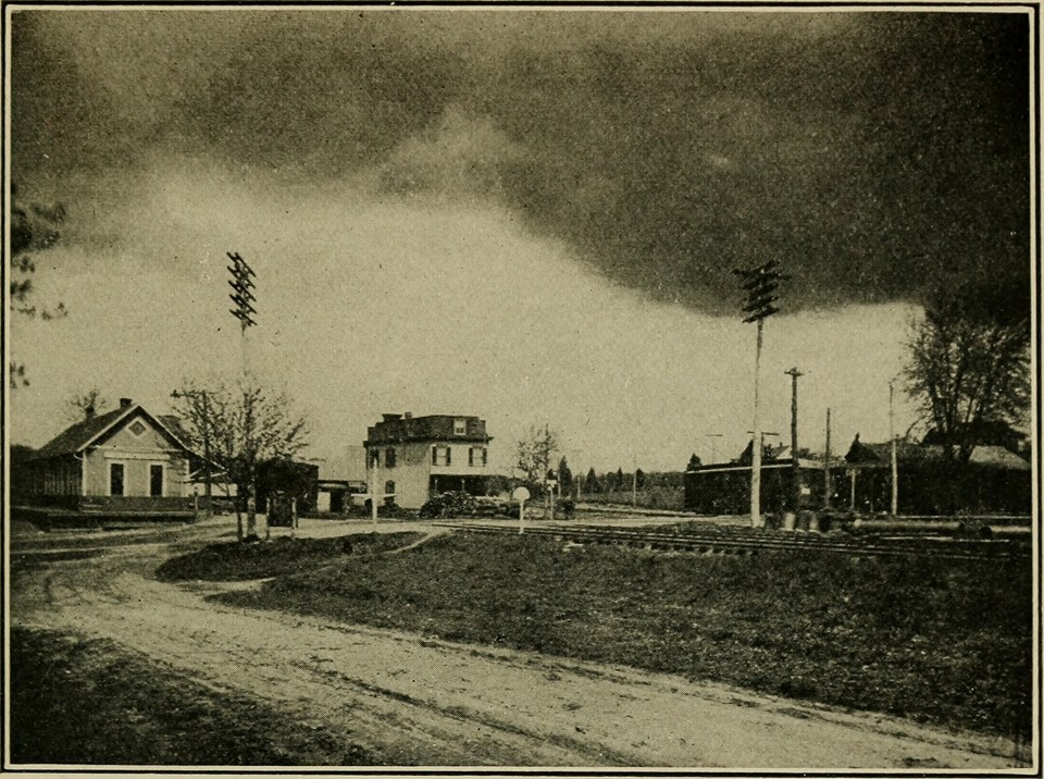
References
- Ball, Frank L. (1966). Electric Railways of Arlington. Arlington Historical Magazine.
- Evans, D'Anne A. (1991). The Story of Oakton, Virginia: 1758–1990. OCLC 76901310.
- Harrison, Noel G. (1985). Along The Tracks: Northern Fairfax County's First Electric Railway. Fredericksburg, Virginia: Mary Washington College. OCLC 13714464.
- Harwood, Herbert H., Jr. (April 2000). Rails to the Blue Ridge: The Washington and Old Dominion Railroad, 1847 – 1968 (PDF) (3rd ed.). Fairfax Station, Virginia: Northern Virginia Parks Authority. pp. 19–144. ISBN 0615114539. LCCN 77104382. OCLC 44685168. Archived from the original (PDF) on September 28, 2017. In Appendix K of Northern Virginia Regional Park Authority - Pre-filed Direct Testimony of Mr. Hafner, Mr. Mcray and Mr. Simmons, November 30, 2005 (Parts 4 and 5), Case No. PUE-2005-00018, Virginia State Corporation Commission. Obtained in "Case Docket Search". Virginia State Corporation Commission. Retrieved September 28, 2017.
- Holt, Kathryn (1986). Cherries, Characters, and Characteristics: A History of Cherrydale. OCLC 15626626.
- King, Jr., Leroy O. (1972). 100 Years of Capital Traction: The Story of Streetcars in the Nation's Capital. Taylor Publishing. ISBN 0960093818. OCLC 701468. LCC HE4491.W37 K55.
- Kohler, Peter C. (2000). Capital Transit: Washington's Street Cars, the Final Era 1933–1962. ISBN 0971293600. OCLC 52882332.
- Merriken, John E. (1987). Old Dominion Trolley Too: A History of the Mount Vernon Line. ISBN 0-9600938-2-6. LCCN 86091361. OCLC 17605355.
- Stuntz, Connie Pendleton; Sturdevant, Mayo (1987). This Was Vienna, Virginia: Facts and Photos. OCLC 18798819.
- Williams, Ames W (1989). The Washington and Old Dominion Railroad. ISBN 0-926984-00-4. OCLC 20461397.
External links
- Northern Virginia Conservation Trust
- National Capital Trolley Museum
- A memorial site for DC Transit
- Online exhibit of Washington streetcars from the National Museum of American History
- "Washington, D.C. Railroad History: Major Railroads Serving Washington, D.C. in 1950". DCNRHS: The National Railway Historical Society, Washington, D.C. Chapter, Inc. Retrieved February 1, 2012.
- "Washington, Arlington, and Falls Church Railway timetables for Arlington and Fort Myer Line and for Fairfax Line" (photograph). Retrieved October 31, 2018 – via Google Books.
- Before the Beltway: Streetcar Lines in Northern Virginia, an online exhibit from the Alexandria Public Library
- Velte, Lawrence E. "The Penrose Trolley". On-The-Pike. Archived from the original on September 28, 2007. Retrieved February 1, 2012. Brief history of Washington-Virginia Railroad with photographs of cars and route map in Arlington.
- Washington, Arlington and Falls Church Ry. Advertisement in "Industrial and Historical Sketch of Fairfax County, Virginia". Fairfax County Board of Supervisors. 1907. p. 88. Retrieved November 10, 2018 – via Google Books.
- Through the Most Historic Section of Virginia: Quickest, Most Convenient and Interesting Route to Mt. Vernon, Alexandria, Arlington National Cemetery via the Washington, Alexandria & Mt. Vernon Railway. Advertisement in "Industrial and Historical Sketch of Fairfax County, Virginia". Fairfax County Board of Supervisors. 1907. p. 90. Retrieved November 10, 2018 – via Google Books.
- McCray, Paul. "Washington & Old Dominion Railroad, 1847 to 1968: A Photographic History". Retrieved February 1, 2012. Website describing the history of the Washington & Old Dominion Railroad and the Great Falls & Old Dominion Railroad, with photographs and lists of stations.
- "Penrose and the Commuter Rail System". Penrose Neighborhood Conservation Plan Final Draft (PDF). Arlington, Virginia: Arlington County Department of Community Planning, Housing and Development. November 2003. pp. 1–8 through 1–9. Archived from the original (PDF) on May 7, 2019. Retrieved May 7, 2019.
- Rosslyn Circle History with photo from 1925