Great Falls and Old Dominion Railroad
The Great Falls and Old Dominion Railroad (GF&OD) was an interurban trolley line that ran in Northern Virginia during the early 20th century.
History

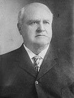
Chartered in 1900 by a group of local landowners and acquired in 1902 by John Roll McLean (owner of The Washington Post) and Senator Stephen Benton Elkins,[1] the 15-mile electrified railroad began operating from Georgetown in Washington, D.C., in 1906. The first scheduled car reached Great Falls Park in Fairfax County, Virginia, on July 3 of that year.[2]
From Georgetown, the railroad crossed the Potomac River on a superstructure built on the upstream side of the old Aqueduct Bridge to Rosslyn in Arlington, where it made connections with an older electric trolley line, the Washington, Arlington & Falls Church Railway (see Northern Virginia trolleys).[3] From Rosslyn, the railroad traveled northwest along the north side of Lee Highway (now part of U.S. Route 29) to Cherrydale and then on its own right-of-way (now Old Dominion Drive, Virginia State Route 309) in Arlington and Fairfax Counties through forests, farmland and fruit orchards, bypassing the existing villages of Lewinsville and Langley.[4] At Great Falls, the GF&OD constructed a trolley park, which became a popular destination.
The owners gave their own names to two stations located at the railroad's crossings of major roads: McLean Station at Chain Bridge Road (Virginia State Route 123) and Elkins Station at Old Georgetown Pike (Virginia State Route 193). The station at Chain Bridge Road became a focus for development that evolved into the community of McLean, Virginia.
In 1911, McLean and Elkins incorporated the Washington & Old Dominion Railway (W&OD). In 1912, the Georgetown-Great Falls line became the Great Falls Division of the W&OD, sharing trackage with the W&OD's Bluemont Division between Rosslyn and Thrifton Junction. In 1935, Fairfax and Arlington counties obtained the right-of-way west of Thrifton Junction in settlement of delinquent taxes. Most of the right-of-way was converted into Old Dominion Drive.
Interstate 66, the Custis Trail, and Lee Highway were built on the former GF&OD roadbed between Rosslyn and Thrifton Junction.
Stations
The stations on the Great Falls Division of the W&OD (with locations of sites in 2008) were:
| Station[5] | Location | Coordinates | Jurisdiction | Side of Tracks[6] | Photo | Notes |
|---|---|---|---|---|---|---|
| Georgetown[7] | M Street, N.W., between 35th and 37th Streets, N.W. | 38°54′19″N 77°04′13″W | District of Columbia | West | Terminal station of GF&OD and W&OD until 1923. Adjacent to Georgetown Car Barn, which served Washington's electric street cars. | |
| Rosslyn[7] | Passenger Terminal (1923 to 1938): Fort Myer Drive (west side) between George Washington Memorial Parkway and Lee Highway |
38°53′58″N 77°04′18″W | Arlington County | West | undated colorized postcard & 1923 interior photo of passenger terminal | The GF&OD and W&OD stopped at a passenger shelter from 1904 to 1923. The W&OD terminated behind a passenger station on Fort Myer Drive from 1923 to 1938. The railroad terminated near a maintenance shop in the present route of I-66 a short distance west of Fort Myer Drive from 1938 to 1964. All of the Rosslyn stations and termini were near the present site of the Key Bridge Marriott Hotel. Historical Marker: Rosslyn Station[8] |
| Colonial[7] | I-66 at N. Nash Street | 38°53′55″N 77°04′25″W | Arlington County | South | ||
| Rosslyn Freight House[7] | I-66 near N. Oak Street | 38°53′55″N 77°04′32″W | Arlington County | North | ||
| Mackeys[7] | I-66 at N. Quinn Street | 38°53′52″N 77°04′44″W | Arlington County | Northwest | ||
| Park Lane[7] | I-66 east of N. Uhle Street; north of Lee Highway | 38°53′50″N 77°05′04″W | Arlington County | Southwest | ||
| Pearce[7] | I-66 near N. Adams Street | 38°53′54″N 77°05′22″W | Arlington County | South | ||
| Clark[7] | I-66 near N. Calvert Street | 38°53′52″N 77°05′35″W | Arlington County | South | Near east side of Spout Run. | |
| Thrifton[7] | I-66 between Lee Highway and Spout Run Parkway | 38°53′48″N 77°05′53″W | Arlington County | South | North of Lyon Village shopping center near southeast end of Maywood Historic District.[9] Named for Hugh A. Thrift.[10] East of junction with Thrifton – Bluemont Junction connecting line. | |
| Dominion Heights[11] | Lee Highway (between traffic lanes) at N. Monroe Street (east side)[12] | 38°53′46″N 77°06′15″W | Arlington County | South | Adjacent to Maywood Historic District[12] | |
| Cherrydale[11] | Intersection of Lee Highway and Old Dominion Drive at Military Road (east side) | 38°53′49″N 77°06′30″W | Arlington County | Southwest | circa 1908 | |
| Harrison[11] | Old Dominion Drive at N. Thomas Street | 38°53′58″N 77°06′51″W | Arlington County | South | ||
| Greenwood[11] | Old Dominion Drive at Lorcom Lane (northwest side); east of N. Vermont Street | 38°53′57″N 77°07′01″W | Arlington County | South | ||
| Maplewood[11] | Old Dominion Drive between traffic lanes north of Lee Highway; west of N. Abingdon Street | 38°53′55″N 77°07′17″W | Arlington County | South | ||
| Livingston[11] | Old Dominion Drive at 24th Street N. (north side) | 38°54′03″N 77°07′28″W | Arlington County | Southwest | 24th Street N. was Livingstone Street prior to 1932 (named for Colin H. Livingstone) | |
| Lyonhurst[11] | Old Dominion Drive at 25th Street N. | 38°54′07″N 77°07′33″W | Arlington County | Southwest | Named for the nearby estate of Frank Lyon (now Missionhurst) | |
| Summit[11] | Old Dominion Drive at 26th Street N. (southeast side) | 38.902907°N 77.127108°W | Arlington County | Southwest | ||
| Rixey[11] | Old Dominion Drive at N. Glebe Road (east side) | 38°54′15″N 77°07′43″W | Arlington County | Northeast | undated | Named for the nearby estate of Dr. Presley Marion Rixey. Marymount University now occupies the Rixey estate. Later station on southwest side of tracks.[13] |
| Jewell[14] | Old Dominion Drive at Rock Spring Road (north side) | 38°54′28″N 77°07′58″W | Arlington County | Southwest | undated | Named for Charles Jewell |
| Vanderwerken[14] | Old Dominion Drive at Little Falls Road (northwest side) | 38°54′35″N 77°08′13″W | Arlington County | North | Named for Gilbert Vanderwerken | |
| Franklyn Park[14] | Old Dominion Drive at Franklin Park Road | 38°54′55″N 77°08′54″W | Fairfax County | Northeast | undated | |
| Rockwell[14] | Old Dominion Drive near Dominion Crest Lane | 38°55′06″N 77°09′00″W | Fairfax County | Southwest | ||
| Chesterbrook[14] | Old Dominion Drive at Kirby Road (northwest side) | 38°55′18″N 77°09′13″W | Fairfax County | Northeast | ||
| El Nido[15] | Old Dominion Drive at Birch Road | 38°55′26″N 77°09′42″W | Fairfax County | North | ||
| Selva[15] | Old Dominion Drive at 6th Place | 38°55′35″N 77°09′57″W | Fairfax County | Southwest | ||
| Viresco[15] | Old Dominion Drive between Pimmit Run and Linway Terrace | 38°55′44″N 77°10′04″W | Fairfax County | Northeast | Southeast side of B&O Railroad right-of-way[15][16] | |
| Lawnvale[15] | Old Dominion Drive near Holmes Place | 38°55′51″N 77°10′22″W | Fairfax County | Southwest | ||
| McLean[15] | Old Dominion Drive at Chain Bridge Road (northwest side) | 38°56′03″N 77°10′40″W | Fairfax County | Northeast | Named for John Roll McLean | |
| Ingleside[15] | Old Dominion Drive at Ingleside Avenue | 38°56′09″N 77°10′59″W | Fairfax County | Northeast | ||
| Balls Hill[17] | Old Dominion Drive at Balls Hill Road (east side) | 38°56′30″N 77°11′39″W | Fairfax County | West | ||
| Hitaffer[17] | Old Dominion Drive at Swinks Mill Road (south side) | 38°56′48″N 77°12′41″W | Fairfax County | Northeast | ||
| Jackson[17] | Old Dominion Drive northwest of Swinks Mill Road | 38°56′51″N 77°12′50″W | Fairfax County | Southwest | undated | |
| Spring Hill[18] | Old Dominion Drive at Spring Hill Road (east side) | 38°57′10″N 77°13′35″W | Fairfax County | Northeast | ||
| Prospect Hill[18] | Old Dominion Drive at Bellview Place | 38°57′30″N 77°14′11″W | Fairfax County | Northeast | undated | |
| Belleview[18] | Old Dominion Drive at Bellview Road | 38°57′40″N 77°14′25″W | Fairfax County | Southwest | undated | |
| Glendale[19] | Old Dominion Drive at Towlston Road | 38°58′12″N 77°14′58″W | Fairfax County | Southwest | ||
| Peacock[19] | Old Dominion Drive at Peacock Station Road (east side) | 38°58′25″N 77°15′12″W | Fairfax County | Southwest | undated | |
| Fairview[19] | Old Dominion Drive at Falls Run Road | 38°58′40″N 77°15′26″W | Fairfax County | West | ||
| Elkins[19] | Old Dominion Drive at Georgetown Pike (north side) | 38°58′54″N 77°15′25″W | Fairfax County | West | undated | Named for Stephen Benton Elkins. |
| Dickeys Road | Old Dominion Drive in Great Falls Park | 38°59′36″N 77°15′20″W | Fairfax County (National Park Service) | Named for Dickey's Inn. Near former site of Matildaville. | ||
| Great Falls[19] | Old Dominion Drive in Great Falls Park | 38°59′48″N 77°15′19″W | Fairfax County (National Park Service) | Inside turnaround | 1. undated postcard 2. undated photo |
Terminal station of GF&OD and Great Falls Division of W&OD. |
Maps
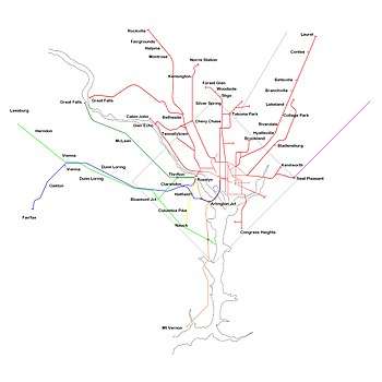
W&OD Railway system maps
- "Washington and Old Dominion Railway system map". c. 1920. Archived from the original on January 7, 2011. Retrieved May 26, 2019 – via r2parts.net.
Topographic Maps
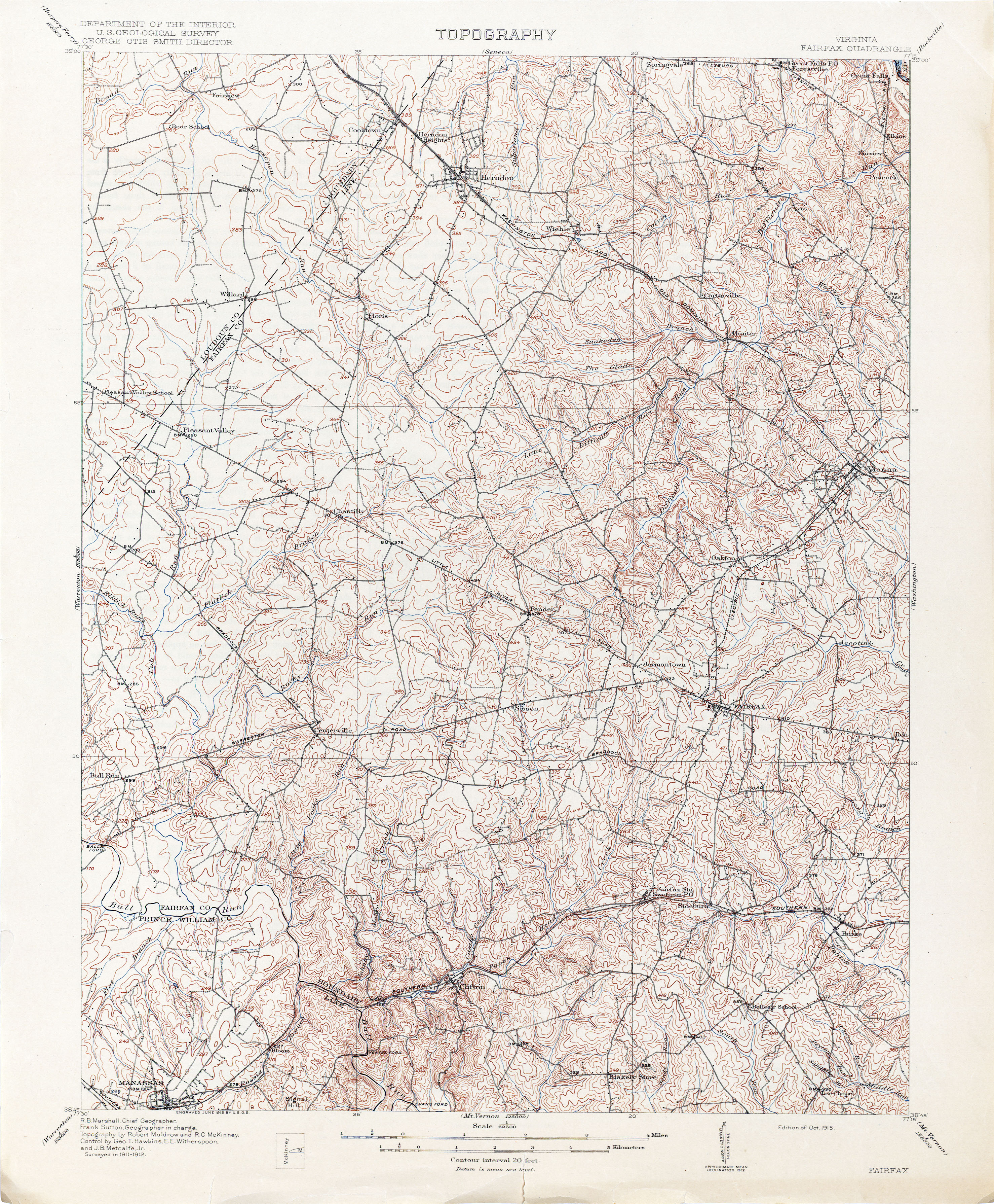
- 1915 topographic map of northwestern Fairfax County, showing the route of the W&OD Railway's Great Falls Division (Electric RR) between Difficult Run and Great Falls: Marshall, R. B.; Sutton, Frank (1915). "Topography: Virginia: Fairfax Quadrangle". Washington, D.C.: United States Department of the Interior: United States Geological Survey. Retrieved January 20, 2020 – via Virginia Historical Topographic Maps, Perry–Castañeda Library Map Collection, Perry–Castañeda Library, University of Texas at Austin, Austin, Texas.
- 1915 topographic map of Washington, D.C., the city of Alexandria, Alexandria County, Falls Church and northeastern Fairfax County, showing the route of the W&OD Railway's Great Falls Division between Georgetown and Great Falls: Marshall, R. B.; Sutton, Frank (1915). "Topography: Maryland — District of Columbia — Virginia, Washington and vicinity". Washington, D.C.: United States Department of the Interior: United States Geological Survey. LCCN 87691472. Retrieved July 24, 2020 – via Library of Congress.
- 1917 topographic map of Washington, D.C., the city of Alexandria, Alexandria County, Falls Church and northeastern Fairfax County, showing the route of the W&OD Railway's Great Falls Division between Georgetown and Great Falls: Marshall, R. B.; Sutton, Frank (1917). "Washington and Vicinity: Maryland: District of Columbia: Virginia". Washington, D.C.: United States Department of the Interior: United States Geological Survey. LCCN 87691475. OCLC 15519039. Retrieved July 24, 2020 – via Library of Congress.
- 1929 topographic map of Washington, D.C., the city of Alexandria, Alexandria County, Falls Church and northeastern Fairfax County, showing the routes of the W&OD Railway's Great Falls Division between Rosslyn and Great Falls:"Washington and Vicinity: Maryland: District of Columbia: Virginia". Washington, D.C.: United States Department of the Interior: United States Geological Survey. 1929. LCCN 87693006. OCLC 15653164. Retrieved July 24, 2020 – via Library of Congress.
See also
- Northern Virginia Trolleys
- Washington and Old Dominion Railroad
Notes
- Harwood, p. 37.
- Harwood, pp. 39-40.
- Undated photograph of Great Falls & Old Dominion Railroad car crossing the Potomac River on the Aqueduct Bridge
- "Undated photograph of Washington & Old Dominion Railway tracks and Lee Highway near Cherrydale". Retrieved November 9, 2018 – via Pinterest.
- Locations of stations from distances along railroad route from Interstate Commerce Commission. "GF&OD Railroad 1916 ICC Valuation Maps". Washington & Old Dominion Regional Park: History. NOVA Parks. Archived from the original on December 26, 2018. Retrieved December 26, 2018. and Harwood, pp. 139 and 141
- Side of tracks from Interstate Commerce Commission. "GF&OD Railroad 1916 ICC Valuation Maps". Washington & Old Dominion Regional Park: History. NOVA Parks. Archived from the original on December 26, 2018. Retrieved December 26, 2018.
- "GF&OD Railroad 1916 ICC Valuation Map No. 2" (PDF). Washington & Old Dominion Regional Park: W&OD Railroad Maps. Northern Virginia Regional Park Authority. July 1, 1916. Archived from the original (PDF) on October 8, 2013. Retrieved January 7, 2015.
- Rosslyn Station historical marker located at site of Bluemont Junction station of Washington and Old Dominion Railroad. See: Washington and Old Dominion Railroad#Stations
- Albee, Carrie E.; Trieschmann, Laura V. (EHT Traceries. Inc.) (November 2002). "Maywood Historic District" (PDF). National Register of Historic Places: Registration Form. Virginia Department of Historic Resources. p. 65 (Section 8). Retrieved November 12, 2018. and Accompanying map
- Albee, Carrie E.; Trieschmann, Laura V. (EHT Traceries. Inc.) (November 2002). "Maywood Historic District" (PDF). National Register of Historic Places: Registration Form. Virginia Department of Historic Resources. p. 50 (Section 8). Retrieved November 12, 2018.
- "GF&OD Railroad 1916 ICC Valuation Map No. 3" (PDF). Washington & Old Dominion Regional Park: History: W&OD Railroad Maps. NOVA Parks. July 1, 1916. Archived from the original (PDF) on November 10, 2018. Retrieved November 10, 2018.
- Albee, Carrie E.; Trieschmann, Laura V. (EHT Traceries. Inc.) (November 2002). "Maywood Historic District" (PDF). National Register of Historic Places: Registration Form. Virginia Department of Historic Resources. pp. 59–60 (Section 8). Retrieved November 12, 2018.
- Note: Rixey station in undated photo was on southwest side of tracks, east of N. Glebe Road (Coordinates: 38°54′14″N 77°07′41″W.
- "GF&OD Railroad 1916 ICC Valuation Map No. 4" (PDF). Washington & Old Dominion Regional Park: W&OD Railroad Maps. Northern Virginia Regional Park Authority. July 1, 1916. Archived from the original (PDF) on March 11, 2013. Retrieved January 7, 2015.
- "GF&OD Railroad 1916 ICC Valuation Map No. 5" (PDF). Washington & Old Dominion Regional Park: W&OD Railroad Maps. Northern Virginia Regional Park Authority. July 1, 1916. Archived from the original (PDF) on October 8, 2013. Retrieved January 7, 2015.
- Coalition for the Capital Crescent Trail. "The Georgetown Branch Railroad". HMdb.org: The Historical Marker Database (photographed by Tom Fuchs, Greenbelt, MD, 2006-01-21). Retrieved January 27, 2012. Description of planned Baltimore and Ohio (B&O) Railroad branch in Virginia.
- "GF&OD Railroad 1916 ICC Valuation Map No. 6" (PDF). Washington & Old Dominion Regional Park: W&OD Railroad Maps. Northern Virginia Regional Park Authority. July 1, 1916. Archived from the original (PDF) on October 8, 2013. Retrieved January 7, 2015.
- "GF&OD Railroad 1916 ICC Valuation Map No. 7" (PDF). Washington & Old Dominion Regional Park: W&OD Railroad Maps. Northern Virginia Regional Park Authority. July 1, 1916. Archived from the original (PDF) on October 8, 2013. Retrieved January 7, 2015.
- "GF&OD Railroad 1916 ICC Valuation Map No. 8" (PDF). Washington & Old Dominion Regional Park: W&OD Railroad Maps. Northern Virginia Regional Park Authority. July 1, 1916. Archived from the original (PDF) on October 8, 2013. Retrieved January 7, 2015.
References
- Harwood, Herbert H., Jr. (April 2000). Chapter 3: The Great Falls Trolley: 1903-1911 (PDF). Rails to the Blue Ridge: The Washington and Old Dominion Railroad, 1847 – 1968 (3rd ed.). Fairfax Station, Virginia: Northern Virginia Parks Authority. pp. 33–42. ISBN 0615114539. LCCN 77104382. OCLC 44685168. Archived from the original (PDF) on September 28, 2017. Retrieved July 25, 2020. In Appendix K of Northern Virginia Regional Park Authority - Pre-filed Direct Testimony of Mr. Hafner, Mr. Mcray and Mr. Simmons, November 30, 2005 (Part 5), Case No. PUE-2005-00018, Virginia State Corporation Commission. Obtained in "Case Docket Search". Virginia State Corporation Commission. Retrieved July 25, 2020.
Further reading
- Williams, Ames W (1989). The Washington and Old Dominion Railroad. Arlington, Virginia: Arlington Historical Society. ISBN 0-926984-00-4. OCLC 20461397.
- Interstate Commerce Commission (July 1, 1916). "GF&OD Railroad 1916 ICC Valuation Maps". Washington & Old Dominion Regional Park: History: W&OD Railroad Maps. NOVA Parks. Archived from the original on November 10, 2018. Retrieved November 10, 2018.
- King, W.E. (1934-07-19). Index map showing Washington & Old Dominion Railway's line abandoned in relation to other railroads and common carriers in lower left corner of "GF&OD Railroad 1916 ICC Valuation Map No. 3" (PDF). Washington & Old Dominion Regional Park: History: W&OD Railroad Maps. NOVA Parks. July 1, 1916. Archived from the original (PDF) on November 10, 2018. Retrieved November 10, 2018.
External links
- Historic Great Falls of Potomac: Scenic Beauty Around Great Falls Grand and Picturesque—Waterfalls Reached by the Great Falls and Old Dominion Railroad: Spots of Historic Interest Passed en Route Over One of the Finest Double-Track Roads in the United States. Advertisement in Industrial and Historical Sketch of Fairfax County, Virginia. Fairfax County Board of Supervisors. 1907. p. 92. Retrieved February 2, 2014 – via Google Books.
- "Historical Background: Old Dominion Drive Notable Facts (Formerly the Great Falls and Old Dominion Railroad)". greenwayheightshistory.com. Eloise Lorenze. Archived from the original on December 30, 2019. Retrieved December 30, 2019. Photographs of stations, tickets and promotional materials about the Great Falls and Old Dominion Railroad and the Great Falls Division of the Washington & Old Dominion Railway.
- "Northern Virginia Regional Park Authority historical marker: "The Great Falls Line"". The Historical Marker Database. February 2, 2010. Retrieved November 15, 2014.
- Swain, Craig (photographer) (November 22, 2009). "Circa 1920 system map of Washington and Old Dominion Railway". Northern Virginia Regional Park Authority. Retrieved December 28, 2015. In "Close-up of the Railroad Map". Photograph number 2 in "Bluemont Junction" marker. The Historical Marker Database. Retrieved December 28, 2015. Map shows stations and route of Great Falls Division of W&OD (former route of GF&OD).