Newtownabbey
Newtownabbey (from Irish: Baile na Mainistreach [ˈbˠalʲə n̪ˠə ˈmˠanʲəʃtʲɾʲəx])[1] is a large settlement north of Belfast in County Antrim, Northern Ireland. Sometimes considered to be a suburb of Belfast, it is separated from the rest of the city by Cavehill and Fortwilliam golf course. At the 2011 Census, Metropolitan Newtownabbey Settlement had a population of 65,646, making it the third largest settlement in Northern Ireland.[2] It is part of Antrim and Newtownabbey Borough Council.
Newtownabbey
| |
|---|---|
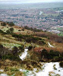
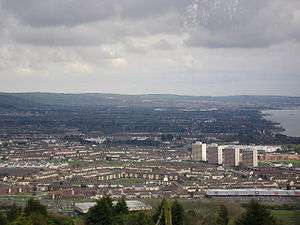 Overlooking the Rathcoole area of Newtownabbey from Cavehill | |
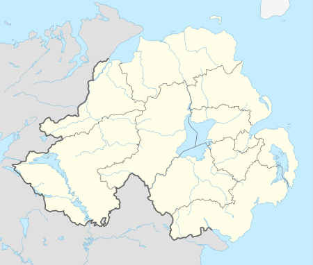 Location within Northern Ireland | |
| Population | 65,646 (2011 Census) |
| District | |
| County | |
| Country | Northern Ireland |
| Sovereign state | United Kingdom |
| Post town | NEWTOWNABBEY |
| Postcode district | BT36, BT37 |
| Dialling code | 028 |
| Police | Northern Ireland |
| Fire | Northern Ireland |
| Ambulance | Northern Ireland |
| UK Parliament | |
| NI Assembly | |
Largely a residential area, Newtownabbey is also home to many engineering and computer industries. Retail and leisure facilities include the Abbey Centre, the Valley Leisure Centre, the Ballyearl Arts & Leisure Centre, The Theatre at the Mill, Glengormley Moviehouse, Glengormley Sportsbowl and three large public parks. The main campus for the University of Ulster is based in the Jordanstown area of Newtownabbey. Although the Jordanstown campus of the University of Ulster merged with the current Belfast campus in 2018.
History
Newtownabbey was formed by the merging of seven villages; Carnmoney, Glengormley, Jordanstown, Monkstown, Whiteabbey, Whitehouse and Whitewell. It was formally brought into being on 1 April 1958. Before its inception, the expanse fell under the jurisdiction of the Belfast Rural District Council.
The timeline of the local government authority is: Newtownabbey Urban District Council (1958–1973), Newtownabbey District Council (1973–1977), Newtownabbey Borough Council (1977–2015) and Antrim & Newtownabbey District Council (2015– ).
The Troubles
For more information see The Troubles in Newtownabbey, which includes a list of incidents in Newtownabbey during The Troubles resulting in two or more deaths.
Geography
Townlands
Below is a list of townlands that are within Newtownabbey's urban area, alongside their likely etymologies.
- Ballybought (from Irish: Baile Bocht, meaning "poor town")*
- Ballyduff (historically Ballymacelduffe; from Baile Mhic Giolla Dhuibh meaning "MacElduff's townland")*
- Ballygolan (historically Ballingowlan; from Baile an Ghabhláin or Baile Gobhláin meaning "townland of the fork")*
- Ballyhenry (from Baile Éinrí meaning "Henry's townland")*
- Ballyvesey (from Baile Feasoighe meaning "Vesey's townland")*
- Ballywonard (from Baile Mhuine Ard meaning "townland of the high thicket")*
- Carnmoney (from Carn Monaidh meaning "cairn of the bog")*
- Collinward (from Coll an Bháird meaning "the bard's hazel")*
- Cloughfern (historically Ballycurraghfarny; from Cruach Fearna meaning "stack of the alder" or Currach Fearnaí meaning "marsh of the place of alders")*
- Drumnadrough (from Druimainn Dorcha meaning "dark ridge" or Druim na gCruach meaning "ridge of the stacks"), where Merville Garden Village is located
- Dunanney (from Dún Aine meaning "Aine's stronghold")*
- Glengormley (from Gleann Ghormlaithe meaning "blue-grey valley")*
- Jordanstown (historically Ballyjordan and Ballyjurdan)
- Mallusk or Molusk (historically Moyvluske and Moyvliske; from Maigh Bhloisce meaning "Bloisce's plain")*
- Monkstown (historically Ballynamanagh; from Baile na Manach meaning "townland of the monks")
- Whiteabbey (from An Mhainistir Fhionn meaning "White Abbey")
- White House (from An Teach Geal meaning "the bright/white house")
* citation for derivations[3]
The following housing estates have Irish-derived names, although they are not named after townlands:[4]
- Mossley (O.E. mos meaning "peat-bog" + O.E. leah meaning "clearing", gaelicized as Maslaí)
- Rathcoole (likely from Ráth Cúile meaning "nook of the ringfort")
Electoral areas and wards
Until 2014 Newtownabbey operated under its own council comprising Ballyclare, Glengormley, Jordanstown, Carnmoney, Mallusk and Rathcoole. However, from 2014 it has operated as a larger Council after merging with Antrim to create Antrim and Newtownabbey Borough Council. The current electoral ward and areas are:
- Airport (1 DUP, 1 SDLP, 1 Sinn Féin, 2 UUP)
(Aldergrove, Clady, Crumlin, Mallusk, and Templepatrick)
- Antrim (1 Alliance, 2 DUP, 2 UUP, 1 SDLP)
(Antrim Centre, Fountain Hill, Greystone, Springfarm, Steeple, and Stiles)
- Ballyclare (3 DUP, 2 UUP, 1 TUV)
(Ballyclare East, Ballyclare West, Ballynure, Ballyrobert, and Doagh)
- Dunsilly (2 DUP, 1 UUP, 1 SDLP 1 Sinn Féin)
(Cranfield, Parkgate, Randalstown, Shilvodan, and Toome)
- Glengormley Urban (1 Alliance, 3 DUP, 2 UUP, 1 Sinn Féin)
(Ballyhenry, Burnthill, Carnmoney, Collinbridge, Glebe, Glengormley, and Hightown)
- Macedon (1 Alliance, 4 DUP, 1 UUP)
(Abbey, Carnmoney Hill, O'Neill, Rathcoole, Valley, and Whitehouse)
- Three Mile Water (1 Alliance, 3 DUP, 2 UUP)
(Ballyduff, Fairview, Jordanstown, Monkstown, Mossley, and Rostulla)
Demography
On Census day (27 March 2011) there were 65,646 people living in Newtownabbey.[2] Of these:
- 20.26% were aged under 16 years and 15.51% were aged 60 and over
- 48.02% of the population were male and 51.98% were female
- 27.69% were from a Catholic background and 62.21% were from a Protestant or other Christian backgrounds
- 6.40% had some knowledge of the Irish language and 6.98% had some knowledge of Ulster-Scots.
Education
- Higher-level education
- University of Ulster at Jordanstown (UUJ)
- Northern Regional College (NRC)
- Secondary-level education
- Ballyclare High School
- Belfast High School
- Edmund Rice College
- Glengormley High School
- Ballyclare Secondary School
- Abbey Community College
- Primary-level education
- Jordanstown Schools for the Deaf and Blind
- Whitehouse Primary School
- Ashgrove Primary School
- Carnmoney Primary School
- Mossley Primary School
- St Mary's on the Hill
- Glengormley Integrated Primary School
- Mossgrove Primary School
- Hollybank Primary School
Sport
- Cricket
- Academy Cricket Club
- Cliftonville Cricket Club
- Football
- 18th Newtownabbey Old Boys F.C.
- FC Whiteabbey
- Mossley Young Men F.C.
- Nortel F.C.
- Rathcoole F.C.
- Rathfern Rangers F.C.
- U.U.J. F.C.
- Gaelic games
- Hockey
- East Antrim Hockey Club
- Mossley Hockey Club
- Owls Hockey Club
- Rugby
- Academy Rugby Club
- Ballyclare Rugby Club
- Belfast High School Former Pupils Rugby Club
- Ophir Rugby Club
- Boxing
- Glengormley Amateur Boxing Club
Churches
- Abbey Presbyterian Church
- Abbots Cross Congregational Church
- Abbots Cross Presbyterian Church
- Ballycraigy Congregational Church
- Ballyhenry Presbyterian Church
- The Church of the Good Shepherd (United Church of Ireland and Methodist)
- Church of the Holy Spirit (Church of Ireland) Mossley
- Church of the Holy Evangelists (Church of Ireland) Carnmoney
- Glengormley Methodist Church
- Glengormley Presbyterian Church
- Monkstown Baptist Church
- Newtownabbey Free Presbyterian Church
- St Bernard's Catholic Church
- St Brigid's Parish of Mallusk
- St James' Catholic Church
- St Mac Nissi's Catholic Church
- St Mary's on the Hill Catholic Church
- St Mary's Star of the Sea Catholic Church
- St. Patrick's Church (Church of Ireland)
- Straid Congregational Church
- Rathcoole Baptist Church
- The Church of Jesus Christ of Latter-day Saints
- Trinity Reformed Presbyterian Church
- Whiteabbey Congregational Church
- Whiteabbey Methodist Church
- Whiteabbey Presbyterian Church
- Whitehouse Presbyterian Church
- Mossley Methodist Church
Transport
Trains
Northern Ireland Railways runs trains serving three railway stations: Mossley West railway station on the Belfast–Derry railway line and Jordanstown railway station and Whiteabbey railway station on the Belfast–Larne railway line.
Connecting trains run on the Belfast-Derry railway line from Mossley West, "Northbound" to: Antrim, Ballymena, Ballymoney, Coleraine (for the branch to University (Coleraine), Dhu Varren and Portrush), Castlerock, Bellarena, Londonderry. And "Southbound" to Yorkgate, Belfast Central (change for Belfast-Bangor railway line and the Enterprise), Botanic, City Hospital, Belfast Great Victoria Street and onwards.
Whilst the Belfast-Larne railway line serving Whiteabbey and Jordanstown and connects with other stations including the principal stations of Carrickfergus, Whitehead, Larne Town and Larne Harbour, heading "Northbound". And heading "Southbound" the same stations as listed above apply.
Buses
Bus services are provided by Metro.
Notable people
Stephen Boyd (4 July 1931 – 2 June 1977) was a Northern Irish-American actor. Originally from Glengormley, County Antrim, Boyd appeared in some 60 films, most notably as the villainous Messala in Ben-Hur (1959), a role that earned him the Golden Globe Award for Best Supporting Actor – Motion Picture.
Roads
Newtownabbey is linked to the M2 motorway (which passes through it) and the M5 motorway (which begins at its southeastern edge).
Twin towns
Newtownabbey is twinned with:
Newtownabbey has one sister city, as designated by Sister Cities International:

References
- https://www.logainm.ie/en/135874
- "Census 2011 Population Statistics for Metropolitan Newtownabbey Settlement". Northern Ireland Statistics and Research Agency (NISRA). Retrieved 15 August 2019.
- "Northern Ireland Placenames Project". Archived from the original on 1 October 2010. Retrieved 12 June 2010.
- "logainm.ie". logainm.ie.
- "Rybnik Official Website – Twin Towns". 2008 Urząd Miasta Rybnika. Retrieved 1 November 2008.
- "List of Twin Towns in the Ruhr District" (PDF). 2009 Twins2010.com. Archived from the original (PDF) on 28 November 2009. Retrieved 28 October 2009. External link in
|publisher=(help)
External links
| Wikivoyage has a travel guide for Newtownabbey. |
| Wikimedia Commons has media related to Newtownabbey. |
List of towns by population | ||
| Large |  | |
| Medium | ||
| Small | ||
Italics denote settlements that are classed as towns but also have city status
| ||
| Authority control |
|
|---|