National Register of Historic Places listings in LaSalle County, Illinois
This is a list of the National Register of Historic Places listings in LaSalle County, Illinois.

Location of LaSalle County in Illinois
This is intended to be a complete list of the properties and districts on the National Register of Historic Places in LaSalle County, Illinois, United States. Latitude and longitude coordinates are provided for many National Register properties and districts; these locations may be seen together in a map.[1]
There are 32 properties and districts listed on the National Register in the county, including 3 National Historic Landmarks.
- This National Park Service list is complete through NPS recent listings posted August 14, 2020.[2]
Current listings
| [3] | Name on the Register | Image | Date listed[4] | Location | City or town | Description |
|---|---|---|---|---|---|---|
| 1 | Armour's Warehouse |  Armour's Warehouse |
November 7, 1997 (#97001333) |
Junction of William and Bridge Sts. 41°19′28″N 88°36′39″W |
Seneca | |
| 2 | Chicago, Rock Island and Pacific Railroad Depot | 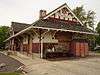 Chicago, Rock Island and Pacific Railroad Depot |
November 7, 1995 (#95001239) |
150 Washington St. 41°19′44″N 88°42′21″W |
Marseilles | |
| 3 | Corbin Farm Site | 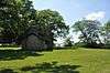 Corbin Farm Site |
June 18, 1998 (#98000654) |
Long Point, between Illinois Route 71 and the Illinois River[5] 41°18′37″N 88°56′21″W |
Utica | |
| 4 | Fisher–Nash–Griggs House |  Fisher–Nash–Griggs House |
November 27, 1998 (#98001353) |
1333 Ottawa Ave. 41°20′28″N 88°51′31″W |
Ottawa | |
| 5 | Ruffin Drew Fletcher House | 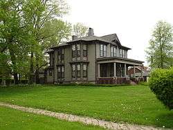 Ruffin Drew Fletcher House |
August 5, 1991 (#91001000) |
609 E. Broadway St. 41°07′35″N 88°49′40″W |
Streator | |
| 6 | Hauge Lutheran Church |  Hauge Lutheran Church |
April 26, 2016 (#15000932) |
3656 E. 2631st Rd. 41°27′54″N 88°39′56″W |
Norway | |
| 7 | Julius W. Hegeler I House | 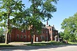 Julius W. Hegeler I House |
February 18, 2009 (#09000028) |
1306 7th St. 41°20′07″N 89°05′17″W |
LaSalle | |
| 8 | Hegeler–Carus Mansion | .jpg) Hegeler–Carus Mansion |
August 9, 1995 (#95000989) |
1307 7th St. 41°20′09″N 89°05′13″W |
LaSalle | |
| 9 | John Hossack House | 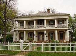 John Hossack House |
March 16, 1972 (#72000462) |
210 W. Prospect St. 41°20′24″N 88°50′28″W |
Ottawa | |
| 10 | Hotel Kaskaskia | 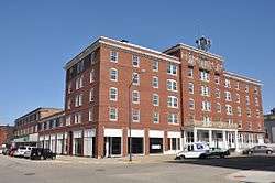 Hotel Kaskaskia |
November 3, 1988 (#88002229) |
217 Marquette St.; also 629 2nd St. 41°19′46″N 89°05′45″W |
LaSalle | Second set of boundaries represents a boundary increase of January 22, 2007, the Hotel Kaskaskia Buildings |
| 11 | Hotel Plaza Site | 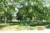 Hotel Plaza Site |
June 18, 1998 (#98000656) |
Northeast of the lodge at Starved Rock State Park[6] 41°19′11″N 88°59′34″W |
Utica | |
| 12 | Knuessl Building | 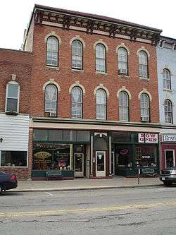 Knuessl Building |
May 11, 1992 (#92000486) |
215-217 W. Main 41°20′46″N 88°50′35″W |
Ottawa | |
| 13 | LaSalle City Building | 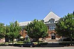 LaSalle City Building |
August 29, 1985 (#85001909) |
745 2nd St. 41°19′46″N 89°05′41″W |
LaSalle | |
| 14 | LaSalle Downtown Commercial District | 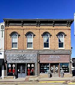 LaSalle Downtown Commercial District |
December 28, 2017 (#100001926) |
400-800 & N side of 900 & 1000 blocks of 1st, 400-700 blocks of 2nd, & 100 & 200 blocks of Wright, Gooding, Marquette Sts. 41°19′43″N 89°05′49″W |
LaSalle | |
| 15 | Little Beaver Site | June 18, 1998 (#98000655) |
Starved Rock State Park, west of Illinois Route 178[7] 41°19′10″N 89°01′16″W |
Utica | ||
| 16 | Marseilles Hydro Plant | 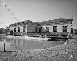 Marseilles Hydro Plant |
May 9, 1989 (#89000343) |
Commercial St. 41°19′37″N 88°42′55″W |
Marseilles | |
| 17 | Marseilles Lock and Dam Historic District | 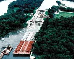 Marseilles Lock and Dam Historic District |
March 10, 2004 (#04000165) |
1 Hawk Dr. 41°19′43″N 88°45′10″W |
Marseilles | |
| 18 | Andrew J. O'Conor III House | 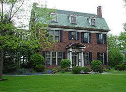 Andrew J. O'Conor III House |
April 22, 1993 (#93000324) |
637 Chapel St. 41°20′55″N 88°49′45″W |
Ottawa | |
| 19 | Old Kaskaskia Village |  Old Kaskaskia Village |
October 15, 1966 (#66000324) |
Dee Bennett Rd. on the northern side of the Illinois River[8] 41°19′19″N 88°57′36″W |
Ottawa | |
| 20 | Ottawa Commercial Historic District |  Ottawa Commercial Historic District |
November 22, 2011 (#11000850) |
Roughly 600-1129 Columbus St. and 601-1215 LaSalle St. 41°21′03″N 88°50′31″W |
Ottawa | |
| 21 | Ottawa East Side Historic District | 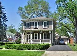 Ottawa East Side Historic District |
September 18, 2013 (#13000718) |
Roughly between the Illinois & Fox Rivers, Shabbona & Green Sts. 41°20′49″N 88°49′55″W |
Ottawa | |
| 22 | Ransom Water Tower |  Ransom Water Tower |
November 2, 1990 (#90001723) |
Plumb St. between Cartier and Columbus 41°09′24″N 88°38′57″W |
Ransom | |
| 23 | Shaky Shelter Site | .jpg) Shaky Shelter Site |
June 18, 1998 (#98000657) |
In a ravine south of Illinois Route 71 at Starved Rock State Park[9] 41°18′22″N 88°56′41″W |
Utica | |
| 24 | Spring Valley House–Sulfur Springs Hotel | Spring Valley House–Sulfur Springs Hotel |
November 20, 1987 (#87002055) |
Dee Bennett Rd. 41°19′23″N 88°57′47″W |
Utica | |
| 25 | Starved Rock |  Starved Rock |
October 15, 1966 (#66000325) |
Starved Rock State Park 41°19′14″N 88°59′26″W |
Utica | |
| 26 | Starved Rock Lock and Dam Historic District | 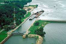 Starved Rock Lock and Dam Historic District |
March 10, 2004 (#04000166) |
Dee Bennett Rd. 41°19′25″N 88°58′36″W |
Utica | |
| 27 | Starved Rock Lodge and Cabins | 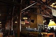 Starved Rock Lodge and Cabins |
May 8, 1985 (#85002702) |
Starved Rock State Park 41°19′07″N 88°59′35″W |
Utica | |
| 28 | Jeremiah Strawn House | 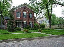 Jeremiah Strawn House |
January 24, 1995 (#94001601) |
532 Congress St. 41°20′49″N 88°50′00″W |
Ottawa | |
| 29 | Streator Public Library | 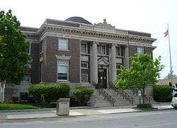 Streator Public Library |
May 2, 1996 (#96000512) |
130 S. Park St. 41°07′10″N 88°50′04″W |
Streator | |
| 30 | Washington Park Historic District | 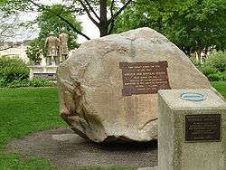 Washington Park Historic District |
April 11, 1973 (#73000710) |
Bounded by Jackson, LaSalle, Lafayette, and Columbus Sts. 41°20′57″N 88°50′30″W |
Ottawa | |
| 31 | Westclox Manufacturing Plant Historic District | 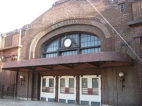 Westclox Manufacturing Plant Historic District |
June 1, 2007 (#07000475) |
300-315 5th St. 41°19′45″N 89°06′35″W |
Peru | Partly destroyed by a fire on January 1, 2012[10] |
| 32 | Silas Williams House | 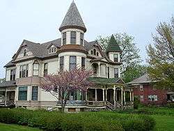 Silas Williams House |
June 23, 1976 (#76002146) |
702 E. Broadway 41°07′29″N 88°49′32″W |
Streator |
See also
| Wikimedia Commons has media related to National Register of Historic Places in LaSalle County, Illinois. |
References
- The latitude and longitude information provided in this table was derived originally from the National Register Information System, which has been found to be fairly accurate for about 99% of listings. Some locations in this table may have been corrected to current GPS standards.
- "National Register of Historic Places: Weekly List Actions". National Park Service, United States Department of the Interior. Retrieved on August 14, 2020.
- Numbers represent an ordering by significant words. Various colorings, defined here, differentiate National Historic Landmarks and historic districts from other NRHP buildings, structures, sites or objects.
- The eight-digit number below each date is the number assigned to each location in the National Register Information System database, which can be viewed by clicking the number.
- Henning, Dale R., and Jacqueline A. Ferguson. National Register of Historic Places Inventory/Nomination: Corbin Farm Site. National Park Service, 1997-12-31, 11.
- Henning, Dale R., and Jacqueline A. Ferguson. National Register of Historic Places Inventory/Nomination: Hotel Plaza Site. National Park Service, 1997-12-31, 14.
- Ferguson, Jacqueline A., and Dale R. Henning. National Register of Historic Places Inventory/Nomination: Little Beaver Site. National Park Service, 1997-12-31, 12.
- Weiss, Francine. National Register of Historic Places Inventory/Nomination: Old Kaskaskia Village. National Park Service, n.d., 1.
- Ferguson, Jacqueline A., and Dale R. Henning. National Register of Historic Places Inventory/Nomination: Shaky Shelter Site. National Park Service, 1997-12-31, 11.
- Keilman, John (January 7, 2012). "Days later, community still angry over Westclox blaze". Chicago Tribune. Retrieved January 31, 2013.
| Topics | |
|---|---|
| Lists by state |
|
| Lists by insular areas | |
| Lists by associated state | |
| Other areas | |
| Related | |
| |
Municipalities and communities of LaSalle County, Illinois, United States | ||
|---|---|---|
| Cities | Map of Illinois highlighting LaSalle County | |
| Villages | ||
| Townships |
| |
| CDPs | ||
| Other unincorporated communities | ||
| Ghost towns | ||
| Footnotes | ‡This populated place also has portions in an adjacent county or counties | |
This article is issued from Wikipedia. The text is licensed under Creative Commons - Attribution - Sharealike. Additional terms may apply for the media files.