National Register of Historic Places listings in Dillon County, South Carolina
This is a list of the National Register of Historic Places listings in Dillon County, South Carolina.
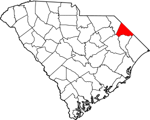
Location of Dillon County in South Carolina
This is intended to be a complete list of the properties and districts on the National Register of Historic Places in Dillon County, South Carolina, United States. The locations of National Register properties and districts for which the latitude and longitude coordinates are included below, may be seen in a map.[1]
There are 18 properties and districts listed on the National Register in the county.
- This National Park Service list is complete through NPS recent listings posted August 14, 2020.[2]
Current listings
| [3] | Name on the Register[4] | Image | Date listed[5] | Location | City or town | Description |
|---|---|---|---|---|---|---|
| 1 | Joel Allen House | August 13, 1974 (#74001848) |
Northwest of Latta 34°24′42″N 79°29′33″W |
Latta | ||
| 2 | Catfish Creek Baptist Church |  Catfish Creek Baptist Church |
January 17, 1975 (#75001697) |
5 miles northwest of Latta at the junction of County Roads 1741 and 1763 34°21′55″N 79°29′36″W |
Latta | |
| 3 | Dillon County Courthouse | 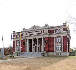 Dillon County Courthouse |
October 30, 1981 (#81000564) |
1303 W. Main St. 34°25′05″N 79°22′32″W |
Dillon | |
| 4 | Dillon Downtown Historic District |  Dillon Downtown Historic District |
January 24, 2003 (#01001549) |
Roughly bounded by E. and W. Main St, N. and S. Railroad Ave, N. MacArthur Ave, and E. Harrison St. 34°25′00″N 79°22′17″W |
Dillon | |
| 5 | Dillon Graded School and Dillon Public School | September 30, 2014 (#14000818) |
405 W. Washington St. 34°25′18″N 79°22′25″W |
Dillon | ||
| 6 | James W. Dillon House |  James W. Dillon House |
May 6, 1971 (#71000769) |
1302 W. Main St. 34°25′07″N 79°22′28″W |
Dillon | |
| 7 | Early Cotton Press |  Early Cotton Press |
November 15, 1972 (#72001206) |
Near the junction of South Carolina Highways 38 and 917 34°20′11″N 79°31′11″W |
Latta | |
| 8 | Hamer Hall |  Hamer Hall |
May 30, 1975 (#75001696) |
North of Hamer on U.S. Route 301 34°29′11″N 79°19′35″W |
Hamer | |
| 9 | James W. Hamer House |  James W. Hamer House |
September 21, 2007 (#07000985) |
1253 Harllees Bridge Rd. 34°28′10″N 79°24′40″W |
Little Rock | |
| 10 | John Hayes Farmstead |  John Hayes Farmstead |
October 4, 2005 (#05001153) |
1251 South Carolina Highway 38, W. 34°20′14″N 79°31′29″W |
Latta | |
| 11 | Latta Downtown Historic District | May 20, 1998 (#98000555) |
Roughly along E. and W. Main Sts. 34°20′15″N 79°25′57″W |
Latta | ||
| 12 | Latta Historic District No. 1 |  Latta Historic District No. 1 |
May 17, 1984 (#84002038) |
Church, Marion, Bethea, Rice, Dew, Mauldin, and Main Sts. 34°20′25″N 79°26′03″W |
Latta | |
| 13 | Latta Historic District No. 2 |  Latta Historic District No. 2 |
May 17, 1984 (#84002040) |
Richardson St., Bamberg to Oak Sts. 34°20′19″N 79°25′50″W |
Latta | |
| 14 | McMillan House |  McMillan House |
May 17, 1984 (#84002042) |
206 Maion St. 34°20′12″N 79°26′06″W |
Latta | |
| 15 | Meekins Barn | August 3, 1984 (#84003815) |
Off South Carolina Highway 9 34°22′25″N 79°16′02″W |
Floydale | ||
| 16 | St. Paul's Methodist Church |  St. Paul's Methodist Church |
July 26, 1977 (#77001220) |
Off South Carolina Highway 9 34°28′38″N 79°24′08″W |
Little Rock | |
| 17 | Selkirk Farm |  Selkirk Farm |
July 24, 1974 (#74001847) |
East of Bingham on Old Cashua Ferry Rd. 34°28′05″N 79°30′15″W |
Bingham | |
| 18 | Smith Barn | .jpg) Smith Barn |
December 4, 1984 (#84000568) |
East of Floydale 34°20′32″N 79°15′10″W |
Floydale |
See also
| Wikimedia Commons has media related to National Register of Historic Places in Dillon County, South Carolina. |
References
- The latitude and longitude information provided in this table was derived originally from the National Register Information System, which has been found to be fairly accurate for about 99% of listings. Some locations in this table may have been corrected to current GPS standards.
- "National Register of Historic Places: Weekly List Actions". National Park Service, United States Department of the Interior. Retrieved on August 14, 2020.
- Numbers represent an ordering by significant words. Various colorings, defined here, differentiate National Historic Landmarks and historic districts from other NRHP buildings, structures, sites or objects.
- "National Register Information System". National Register of Historic Places. National Park Service. March 13, 2009.
- The eight-digit number below each date is the number assigned to each location in the National Register Information System database, which can be viewed by clicking the number.
| Topics |  | |
|---|---|---|
| Lists by county |
| |
| Lists by city |
| |
| Other lists | ||
Municipalities and communities of Dillon County, South Carolina, United States | ||
|---|---|---|
| City | Map of South Carolina highlighting Dillon County | |
| Towns | ||
| Unincorporated communities | ||
This article is issued from Wikipedia. The text is licensed under Creative Commons - Attribution - Sharealike. Additional terms may apply for the media files.