National Register of Historic Places listings in Aiken County, South Carolina
This is a list of the National Register of Historic Places listings in Aiken County, South Carolina.

Location of Aiken County in South Carolina
This is intended to be a complete list of the properties and districts on the National Register of Historic Places in Aiken County, South Carolina, United States. The locations of National Register properties and districts for which the latitude and longitude coordinates are included below, may be seen on a map.[1]
There are 41 properties and districts listed on the National Register in the county, including 1 National Historic Landmark.
- This National Park Service list is complete through NPS recent listings posted August 14, 2020.[2]
Current listings
| [3] | Name on the Register[4] | Image | Date listed[5] | Location | City or town | Description |
|---|---|---|---|---|---|---|
| 1 | Aiken Colored Cemetery |  Aiken Colored Cemetery |
March 19, 2007 (#07000182) |
Florence St. and Hampton Ave. 33°34′16″N 81°43′23″W |
Aiken | |
| 2 | Aiken Mile Track |  Aiken Mile Track |
May 9, 1985 (#85000991) |
Banks Mill Rd. 33°32′39″N 81°41′57″W |
Aiken | |
| 3 | Aiken Training Track |  Aiken Training Track |
May 9, 1985 (#85000992) |
Two Notch Rd. 33°32′35″N 81°42′30″W |
Aiken | |
| 4 | Aiken Winter Colony Historic District I |  Aiken Winter Colony Historic District I |
November 27, 1984 (#84000484) |
Off U.S. Routes 1/78 33°32′59″N 81°44′29″W |
Aiken | |
| 5 | Aiken Winter Colony Historic District II |  Aiken Winter Colony Historic District II |
November 27, 1984 (#84000498) |
Roughly bounded by railroad tracks, Colleton and 3rd Aves., and Laurens, South Boundary, and Marion Sts. 33°33′16″N 81°43′15″W |
Aiken | |
| 6 | Aiken Winter Colony Historic District III |  Aiken Winter Colony Historic District III |
November 27, 1984 (#84000508) |
Roughly bounded by Edgefield Ave., Highland Park Dr., Fauburg, and Greenville St. 33°33′47″N 81°43′40″W |
Aiken | |
| 7 | Chancellor James P. Carroll House |  Chancellor James P. Carroll House |
November 23, 1977 (#77001209) |
112 Gregg Ave. 33°33′59″N 81°45′28″W |
Aiken | |
| 8 | The Cedars |  The Cedars |
June 17, 1993 (#93000539) |
U.S. Route 278, 0.3 miles east of South Carolina Highway 125 33°25′38″N 81°52′50″W |
Beech Island | |
| 9 | Chinaberry |  Chinaberry |
April 29, 1982 (#82003826) |
441 York St., SE. 33°33′11″N 81°43′18″W |
Aiken | |
| 10 | Coker Spring |  Coker Spring |
January 18, 1978 (#78002490) |
Coker Spring Rd. 33°32′59″N 81°43′37″W |
Aiken | |
| 11 | Court Tennis Building |  Court Tennis Building |
November 27, 1984 (#84000513) |
Newberry and Park Sts. 33°33′34″N 81°43′17″W |
Aiken | |
| 12 | Crossways |  Crossways |
June 4, 1997 (#97000536) |
450 E. Boundary St. 33°32′46″N 81°41′27″W |
Aiken | |
| 13 | Dawson-Vanderhorst House |  Dawson-Vanderhorst House |
June 29, 1976 (#76001685) |
Northeast of Aiken at the junction of Wire and New Bridge Rds. 33°34′49″N 81°40′57″W |
Aiken | |
| 14 | Fort Moore-Savano Town Site | August 14, 1973 (#73001670) |
West of Beech Island on the Savannah River[6] 33°25′53″N 81°54′37″W |
Beech Island | ||
| 15 | Gaston Livery Stable | February 27, 2020 (#100005001) |
1315 Richland Ave. East 33°33′15″N 81°42′09″W |
Aiken | ||
| 16 | Georgia Avenue-Butler Avenue Historic District |  Georgia Avenue-Butler Avenue Historic District |
April 5, 1984 (#84002017) |
Georgia and Butler Aves. and Martintown Rd. 33°30′15″N 81°57′52″W |
North Augusta | |
| 17 | Graniteville Historic District | Graniteville Historic District |
June 2, 1978 (#78002491) |
South Carolina Highway 19 and Gregg St. 33°34′03″N 81°48′24″W |
Graniteville | |
| 18 | Charles Hammond House |  Charles Hammond House |
October 2, 1973 (#73001672) |
908 Martintown Rd., W. 33°31′33″N 81°58′47″W |
North Augusta | |
| 19 | Hickman Mill Historic District |  Hickman Mill Historic District |
February 23, 2016 (#16000046) |
Bounded by Marshall, Canal, and Hard Streets, and Horse Creek 33°33′54″N 81°48′33″W |
Graniteville | |
| 20 | Immanuel School |  Immanuel School |
June 3, 2009 (#09000389) |
120 York St., NE 33°33′38″N 81°43′03″W |
Aiken | |
| 21 | Joye Cottage |  Joye Cottage |
September 29, 1980 (#80003651) |
463 Whiskey Rd. and 129 1st Ave. 33°33′12″N 81°43′25″W |
Aiken | |
| 22 | Legare-Morgan House |  Legare-Morgan House |
September 22, 1977 (#77001210) |
241 Lauren St., SW. 33°33′23″N 81°43′30″W |
Aiken | |
| 23 | Lookaway Hall |  Lookaway Hall |
August 13, 1992 (#92000962) |
103 W. Forest Ave. 33°29′56″N 81°58′08″W |
North Augusta | |
| 24 | Britton Mims Place | June 4, 1997 (#97000539) |
229 Edgefield Rd. 33°31′27″N 81°56′59″W |
North Augusta | ||
| 25 | Oakland Plantation |  Oakland Plantation |
August 19, 2011 (#10001219) |
2930 Storm Branch Rd. 33°26′59″N 81°50′17″W |
Beech Island vicinity | |
| 26 | Phelps House |  Phelps House |
June 10, 1974 (#74001819) |
Barnwell Ave. 33°33′56″N 81°43′29″W |
Aiken | |
| 27 | Pickens House | 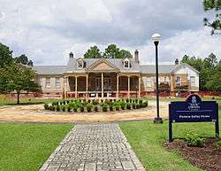 Pickens House |
May 19, 1983 (#83002182) |
101 Gregg Ave. 33°33′55″N 81°45′39″W |
Aiken | |
| 28 | Redcliffe |  Redcliffe |
May 8, 1973 (#73001671) |
1.5 miles northeast of Beech Island on South Carolina Highway 125 33°24′58″N 81°52′56″W |
Beech Island | |
| 29 | Rosemary Hall |  Rosemary Hall |
April 28, 1975 (#75001685) |
804 Carolina Ave. 33°29′49″N 81°58′12″W |
North Augusta | |
| 30 | St. Mary Help of Christians Church |  St. Mary Help of Christians Church |
March 25, 1982 (#82003827) |
York St. and Park Ave. 33°33′28″N 81°43′11″W |
Aiken | |
| 31 | St. Thaddeus Episcopal Church |  St. Thaddeus Episcopal Church |
November 27, 1984 (#84000518) |
Pendleton and Richland Sts. 33°33′41″N 81°43′30″W |
Aiken | |
| 32 | Salley Historic District |  Salley Historic District |
October 27, 2000 (#00000554) |
Bounded by Pine, Ferguson, Poplar, and Aldrich Sts. 33°33′56″N 81°18′17″W |
Salley | |
| 33 | Silver Bluff | November 1, 1977 (#77001211) |
Silver Bluff Rd. on the Savannah River[7] 33°18′38″N 81°50′38″W |
Jackson | ||
| 34 | US Court House-Aiken, South Carolina |  US Court House-Aiken, South Carolina |
December 10, 2003 (#03001288) |
223 Park Ave., SE. 33°33′32″N 81°43′23″W |
Aiken | |
| 35 | Vaucluse Mill Village Historic District | 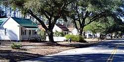 Vaucluse Mill Village Historic District |
May 7, 1996 (#96000494) |
South Carolina Highway 191, 3 miles north of Graniteville and 6 miles west of Aiken 33°36′54″N 81°48′12″W |
Vaucluse | |
| 36 | B.C. Wall House |  B.C. Wall House |
November 27, 1992 (#92001632) |
1008 West Ave. 33°30′08″N 81°58′18″W |
North Augusta | |
| 37 | Warren Mill |  Warren Mill |
September 27, 2016 (#16000678) |
Cty. Rd. P-1201 & SC 421 33°33′07″N 81°48′31″W |
Warrenville | |
| 38 | Warrenville Elementary School |  Warrenville Elementary School |
May 22, 2002 (#02000560) |
115 Timmerman St. 33°32′53″N 81°48′24″W |
Warrenville | |
| 39 | Whitehall |  Whitehall |
November 27, 1984 (#84000527) |
902 Magnolia St. 33°32′31″N 81°43′11″W |
Aiken | |
| 40 | Willcox's |  Willcox's |
March 19, 1982 (#82003828) |
Colleton Ave. 33°33′25″N 81°43′19″W |
Aiken | |
| 41 | Zubly Cemetery |  Zubly Cemetery |
January 28, 2002 (#01001548) |
Forrest Dr. 33°24′20″N 81°54′02″W |
Beech Island |
See also
| Wikimedia Commons has media related to National Register of Historic Places in Aiken County, South Carolina. |
References
- The latitude and longitude information provided in this table was derived originally from the National Register Information System, which has been found to be fairly accurate for about 99% of listings. Some locations in this table may have been corrected to current GPS standards.
- "National Register of Historic Places: Weekly List Actions". National Park Service, United States Department of the Interior. Retrieved on August 14, 2020.
- Numbers represent an ordering by significant words. Various colorings, defined here, differentiate National Historic Landmarks and historic districts from other NRHP buildings, structures, sites or objects.
- "National Register Information System". National Register of Historic Places. National Park Service. March 13, 2009.
- The eight-digit number below each date is the number assigned to each location in the National Register Information System database, which can be viewed by clicking the number.
- "Fort Moore (historical)". Geographic Names Information System. United States Geological Survey.
- "Silver Bluff". Geographic Names Information System. United States Geological Survey.
| Topics | 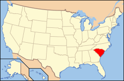 | |
|---|---|---|
| Lists by county |
| |
| Lists by city |
| |
| Other lists | ||
Municipalities and communities of Aiken County, South Carolina, United States | ||
|---|---|---|
| Cities | Map of South Carolina highlighting Aiken County | |
| Towns | ||
| CDPs | ||
| Unincorporated communities | ||
| Ghost town | ||
| Footnotes | ‡This populated place also has portions in an adjacent county or counties | |
This article is issued from Wikipedia. The text is licensed under Creative Commons - Attribution - Sharealike. Additional terms may apply for the media files.