Most (Most District)
Most (Czech pronunciation: [most]; German: Brüx; Latin: Pons) is a city in the Ústí nad Labem Region of the Czech Republic. It is the capital city of the Most District, situated between the Central Bohemian Uplands and the Ore Mountains, approximately 77 km (48 mi) northwest of Prague along the Bílina River and southwest of Ústí nad Labem.
Most | |
|---|---|
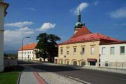 The only remaining street of old Most | |
 Flag  Coat of arms | |
| Etymology: Bridge | |
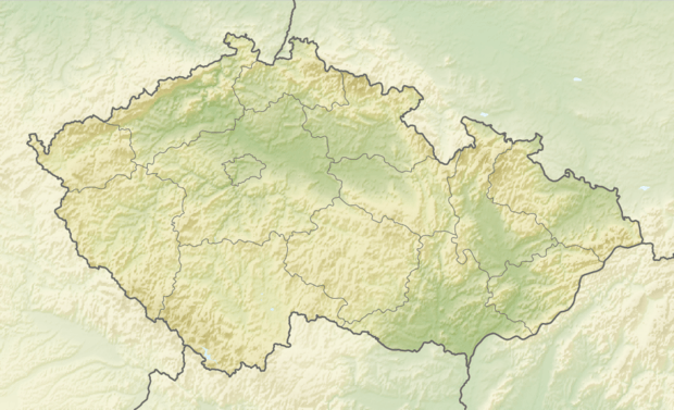 Most Location in the Czech Republic | |
| Coordinates: 50°30′11″N 13°38′12″E | |
| Country | |
| Region | Ústí nad Labem |
| District | Most |
| First documented | 10th century |
| Government | |
| • Mayor | Jan Paparega |
| Area | |
| • Total | 86.94 km2 (33.57 sq mi) |
| Elevation | 233 m (764 ft) |
| Population (2020-01-01[1]) | |
| • Total | 66,034 |
| • Density | 760/km2 (2,000/sq mi) |
| Time zone | UTC+1 (CET) |
| • Summer (DST) | UTC+2 (CEST) |
| Postal code | 434 01 |
| Website | www.mesto-most.cz |
The name Most means "bridge" in Czech. The town, which was named after the system of bridges that crossed the swamps in this area in the 10th century, is now mostly known for its heavy industry. The German name for Most is Brüx (derived from the German word for "bridge", Brücke).
Most lies at the heart of the northern Bohemian lignite-mining region and serves as an important industrial railway junction. During the latter half of the 20th century, Most was considered to be one of the most polluted coal mining towns in communist Czechoslovakia. Most's other industries includes textile, ceramics, steel, and chemicals.
Foreign mining operations continue to operate in the area in the 21st century. Some surrounding villages are planned to be abandoned due to surface mining. However environmental conditions have improved in recent years around Most, in particular the growing of apples and grape vines has developed.
History
Medieval period
The Latin Chronica Boemorum mentions a Slavic settlement below the Gnevin Castle called Gnevin Pons (Czech: Hněvínský most) in 1040. Through the swamps there led a merchant route from Prague to Freiberg. The network of wooden bridges was built to provide comfortable passages through this territory. Hneva from the Hrabišic dynasty established a military stronghold to protect caravans. Under this stronghold, the village that would become Most developed.
In 1227 Kojata, the last of the Hrabisics, passed his property to the cloister of the Knights of the Cross. Between 1238 - 1306 the town was part of the territory possessed by the Přemyslids and it became rich with many churches. The mid-13th century saw the beginning of substantial German immigration as King Ottokar II sought to replace losses from the Mongol invasion of eastern Europe in 1241. Germans settled throughout and primarily along the northern, western, and southern borders of Bohemia, although many lived in towns like Brüx, where they were the majority population, throughout the kingdom. The Bohemian kings Otakar II, John of Luxemburg, and Charles IV all granted city rights to Brüx.
In 1526 Bohemia became part of the Austrian Habsburg monarchy, designated as Crown Lands and the city became head of the BRÜX district, one of the 94 Bezirkshauptmannschaften in Bohemia. Following the Austria-Hungary compromise of 1867 it remained part of Austrian Bohemia.[2]
During the 15th and 16th centuries, the city was hit by several fires. In circa 1530, city reconstruction began with the foundations of several significant facilities, including the new dean's church and the Renaissance city hall.
During the Thirty Years' War, the city was occupied by Swedish troops. Both in the early years and in the last years of the war, it was captured by stratagem. In a similar manner the castle Hněvín was captured. After the Thirty Years' War, the city lost much of its economic and political significance.
19th century growth
In the second half of the 19th century, industry and mining emerged, and in 1870, a railway line was built. Construction included sugar works, porcelain factory, steel works, brewery, and the founding of a city museum. In 1895 the city was affected by quicksand that swallowed several houses, including some of their occupants.
In 1900 the RICO plant for dressing material was constructed. In 1901, an electric tramline linked Brüx with Kopitz up to Johnsdorf. The construction 1911-1914 of a new unique dam at Kreuzweg solved the city's supply of drinking water.
In 1905 Brüx had a population of 21,500 people and the most modern theatre of its time within Austria-Hungary, built in 1910 and designed by Viennese architect Alexander Graf, was opened in Brüx in 1911.[3]
Czechoslovakia
The 1919 Peace Treaties that ended World War I created a new State from the territories of the Czech lands (Bohemia, Moravia) and of Slovakia. This new confederation was called Czechoslovakia, and Brüx was within the borders of the new state.
According to the 1930 census, there were 28 212 citizens living in Brüx (9 740 people of Czechoslovak ethnicity, 17 549 German, 33 Russian and 154 Jewish).[4]
Under the Munich Agreement in 1938, using the census-based Völkerkarte Mitteleuropas ethnicities map of 1937, it was found that Brüx fell within the ethnic German-speaking zone which would become part of the Sudetenland districts to be separated from Czechoslovakia. From 1938 until 1945, the city was administered as a part of the Regierungsbezirk Aussig of Reichsgau Sudetenland.
On 15 December 1942, Brüx began output of Ersatz fuel synthesized from brown coal at the Sudetenländische Treibstoffwerke AG (STW) Maltheuren plant,[5][6] and a subcamp of Sachsenhausen provided forced labor. Stalag IV-C (Wistritz bei Teplitz) was at the "Sudentenland Treibstoff Werke",[7] and Brüx was repeatedly bombed during the Oil Campaign of World War II.
In May 1945 Brüx was restored to Czechoslovakia. Shortly afterwards, the German population was expelled. The city was renamed to its Czech language name of Most, and a degree of resettlement by Czechs took place.
| Nations ruling Most | |
|---|---|
| Early | Hrabišic dynasty |
| 1238 | Přemyslid dynasty |
| 1306 | Kingdom of Bohemia |
| 1526 | Habsburg Monarchy |
| Thirty Years' War | Swedish Empire |
| 1806 | Austrian Empire |
| 1867 | Austria-Hungary |
| 1919 | Czechoslovakia |
| 1938 | Nazi Germany |
| 1945 | Czechoslovakia |
| 1993 | Czech Republic |
Destruction & redevelopment
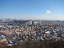
In 1964, the Most Coal Company began the demolition of the historical old town of Most in order to make room for the expanding lignite mines in the area. Financed and led by the Communist government of Czechoslovakia, the company pulled down the town's historic buildings including a brewery dating from the 15th century and the 1910 theatre. New low-cost, standardized, multifamily housing projects were built (paneláky, in reference to the precast concrete panels from which they were made). In the summer of 1968, an American film company shot scenes for the war film The Bridge at Remagen in the town; the clearance work providing realistic looking war-damaged properties.[8] The demolition work ended in 1970.[9]
Although the old town was flattened, the Communist authorities decided to preserve the Gothic Church of the Assumption of the Virgin Mary. The entire building, which was built between 1517 and 1594 and designed by Jakob Heilmann of Schweinfurt, was moved by train to the newly constructed town 2,759 feet [841 meters] away. The move took 28 days to complete at the rate of roughly 98 feet [30 meters] per day. The Czechoslovak government took pride in the relocation of this religious structure, and the building was mentioned in the Guinness Book of World Records as the heaviest building ever moved on wheels.
Today most Czechs consider the decision to demolish Most as a destruction of Bohemian history and culture. Nevertheless, the redevelopment of the new town opened a new industrial era and opportunities in the area. Labor mobility drew skilled and unskilled labor to the mining and construction sectors in Most making it one of the busiest regions in Czechoslovakia.
Modern era
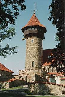
As a redeveloped city, Most does not have many historical sights, yet there are two important ones: Hněvín Castle and the Gothic Church of the Assumption of the Virgin Mary. On the other hand, there are many amusement facilities which can be visited: planetarium, observatory, autodrome, aquadrome or hippodrome.
The Hippodromo (Racecourse) in the Velebudice district of Most was the host of the 18th International Meeting of 2CV Friends between 28 July and 2 August 2009, attracting 3,333 vehicles and approximately 10,000 people.[10]
Districts
- The neighborhood of Rudolice nad Bílinou is home to the Chánov housing estate, created during the communist era, which has become a symbol of the poverty and ghettoization of many Romani people in the Czech Republic.
- Vtelno used to be a village near Most. When the new city was built near it, Vtelno became an integral part of Most. It has a church, a historical Baroque manor, and many monoliths and sculptures that have been collected during the era of demolition of villages in the region (due to coal mining).
Notable people
- Andreas Hammerschmidt (ca. 1611–1675), composer
- Florian Leopold Gassmann (1729–1774), composer
- Rudolf Ritter (1878–1966), tenor
- Wenzel Hablik (1881–1934), painter and architect
- Heini Halberstam (1926–2014), mathematician
- Judita Čeřovská (1929–2001), singer
- Josef Masopust (1931–2015), football player and coach
- Jan Mühlstein (born 1949), politician
- Pavel Chaloupka (born 1959), football player
- Vladimír Růžička (born 1963), ice hockey player
- Libor Pimek (born 1963), tennis player
- Petr Svoboda (born 1966), ice hockey player
- Bedřich Beneš (born 1967), computer scientist
- Martin Ručínský (born 1971), ice hockey player
- Jan Vopat (born 1973), ice hockey player
- Petr Franěk (born 1975), ice hockey player
- Vlastimil Kroupa (born 1975), ice hockey player
- Petr Johana (born 1976), football player
- Marek Židlický (born 1977), ice hockey player
- Pavel Rosa (born 1977), ice hockey player
- Kamil Piroš (born 1978), ice hockey player
- Tomáš Divíšek (born 1979), ice hockey player
- Markéta Jánská (born 1981), model
- Tomáš Kůrka (born 1981), ice hockey player
- Iveta Benešová (born 1983), tennis player
- Lukáš Kašpar (born 1985), ice hockey player
- Nikola Tesla went to the institute of technology in Brüx
References
- "Population of Municipalities – 1 January 2020". Czech Statistical Office. 2020-04-30.
- Die postalischen Abstempelungen auf den österreichischen Postwertzeichen-Ausgaben 1867, 1883 und 1890, Wilhelm KLEIN, 1967
- Baedeker, Karl, Austria-Hungary, Leipzig, 1905, p.237.
- Encyklopedie branné moci Republiky Československé, Jiří Fidler & Václav Sluka
- "HISTORY OF THE COMPANY". chemopetrol.cz.
- "Sudetenl ä ndische Treibstoffwerke AG Oberleutensdorf, Kreis Br ü x (Sudetengau) - Sudeten German factory for motor fuels akc. spol". Translate.google.com. Retrieved 29 April 2009.
- "Summer 2002 Newsletter". The National Ex-Prisoner of War Association. 2002. Archived from the original on 17 October 2014. Retrieved 12 October 2014.
- "American film-makers use Austrian tanks in Most". Euscreen.eu. Retrieved 24 August 2012.
- "Stary Most, Old city Most, Das Verschwundene Brux _1238-1982". YouTube.com. 2008-01-05. Retrieved 2015-03-30.
- Vokurka, Martin (18 June 2009). "Do Mostu míří z celé planety tisíce milovníků starých citroënů". Mostecký deník. Retrieved 21 July 2019.
- "Partnerská města" (in Czech). Statutární město Most. Retrieved 2020-06-08.
- Merriam Webster's Geographical Dictionary, 3rd edition
External links
| Wikisource has the text of the 1911 Encyclopædia Britannica article Brüx. |
- Demolition and construction of the city (in Czech)
| Wikimedia Commons has media related to Most. |