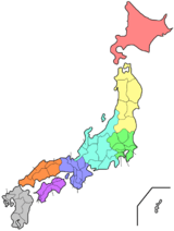
Miyagi Prefecture
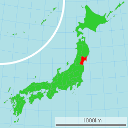
Miyagi Prefecture (宮城県, Miyagi-ken) is a prefecture of Japan located in the Tōhoku region of Honshu.[1] Miyagi Prefecture has a population of 2,305,596 (1 June 2019) and has a geographic area of 7,282 km² (2,811 sq mi). Miyagi Prefecture borders Iwate Prefecture to the north, Akita Prefecture to the northwest, Yamagata Prefecture to the west, and Fukushima Prefecture to the south.
Miyagi Prefecture 宮城県 | |
|---|---|
| Japanese transcription(s) | |
| • Japanese | 宮城県 |
| • Rōmaji | Miyagi-ken |
 Flag  Symbol | |
 | |
| Country | Japan |
| Region | Tōhoku |
| Island | Honshu |
| Capital | Sendai |
| Subdivisions | Districts: 10, Municipalities: 35 |
| Government | |
| • Governor | Yoshihiro Murai |
| Area | |
| • Total | 7,282.22 km2 (2,811.68 sq mi) |
| Area rank | 16th |
| Population (June 1, 2019) | |
| • Total | 2,305,596 |
| • Rank | 15th |
| • Density | 320/km2 (820/sq mi) |
| ISO 3166 code | JP-04 |
| Website | www |
| Symbols | |
| Bird | Wild goose |
| Flower | Miyagi bush clover (Lespedeza thunbergii) |
| Tree | Japanese zelkova (Zelkova serrata) |
Sendai is the capital and largest city of Miyagi Prefecture, and the largest city in the Tōhoku region, with other major cities including Ishinomaki, Ōsaki, and Tome.[2] Miyagi Prefecture is located on Japan's eastern Pacific coast and bounded to the west by the Ōu Mountains, the longest mountain range in Japan, with 24% of its total land area being designated as Natural Parks. Miyagi Prefecture is home to Matsushima Islands, a group of islands ranked as one of the Three Views of Japan, near the town of Matsushima.
History
Miyagi Prefecture was formerly part of the province of Mutsu.[3]
2011 Tōhoku earthquake and tsunami
| Wikinews has related news: |
On March 11, 2011, a 9.0 magnitude earthquake and a subsequent major tsunami hit Miyagi Prefecture, causing major damage to the area.[4] The tsunami was estimated to be approximately 10 meters high in Miyagi Prefecture.[5]
On April 7, 2011, a 7.4-magnitude earthquake struck off the coast of Miyagi, Japan. Workers were then evacuated from the nearby troubled Fukushima Daiichi nuclear facility once again, as a tsunami warning was issued for the coastline. Residents were told to flee for inner land at that time.
Officials from the U.S. Geological Survey later downgraded the magnitude to 7.1 from 7.4.[6]
In 2013, Crown Prince Naruhito and Crown Princess Masako visited the prefecture to see the progress made since the tsunami.[7]
Geography
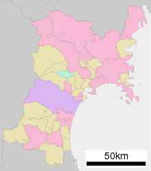
Government Ordinance Designated City City Town Village
Miyagi Prefecture is in the central part of Tōhoku, facing the Pacific Ocean, and contains Tōhoku's largest city, Sendai. There are high mountains on the west and along the northeast coast, but the central plain around Sendai is fairly large.
Matsushima is known as one of the three most scenic views of Japan, with a bay full of 260 small islands covered in pine groves.
Oshika Peninsula projects from the northern coastline of the prefecture.
As of 31 March 2019, 24% of the total land area of the prefecture was designated as Natural Parks, namely the Sanriku Fukkō National Park; Kurikoma and Zaō Quasi-National Parks; and Abukuma Keikoku, Asahiyama, Funagata Renpō, Futakuchi Kyōkoku, Kenjōsan Mangokuura, Kesennuma, Matsushima, and Zaō Kōgen Prefectural Natural Parks.[8][9]
Cities
Fourteen cities are located in Miyagi Prefecture:
- Sendai - the largest and the capital city of the prefecture.
Towns and villages
These are the towns and villages in each district:
|
|
|
|
|
Mergers
Economy
Although Miyagi has a good deal of fishing and agriculture, producing a great deal of rice and livestock, it is dominated by the manufacturing industries around Sendai, particularly electronics, appliances, and food processing.
As of March 2011, the prefecture produced 4.7% of Japan's rice, 23% of oysters, and 15.9% of sauries.[10]
In July 2011, the Japanese government decided to ban all shipments of beef cattle from northeast Miyagi Prefecture over fears of radioactive contamination.[11] This has since been rescinded.
Population
Per Japanese census data,[12] and [13], Miyagi has had fastest growth between 1940-1950 and continued to exhibit growth up until 21st century. Despite Miyagi Prefecture population overall decreasing, its prefecture capital Sendai continues to have population increase.
| Year | Pop. | ±% |
|---|---|---|
| 1890 | 735,100 | — |
| 1920 | 962,000 | +30.9% |
| 1930 | 1,143,000 | +18.8% |
| 1940 | 1,271,000 | +11.2% |
| 1950 | 1,663,000 | +30.8% |
| 1960 | 1,743,000 | +4.8% |
| 1970 | 1,819,000 | +4.4% |
| 1980 | 2,082,000 | +14.5% |
| 1990 | 2,249,000 | +8.0% |
| 2000 | 2,365,320 | +5.2% |
| 2010 | 2,348,165 | −0.7% |
| 2020 | 2,306,000 | −1.8% |
Education
University
- Miyagi University
- Miyagi University of Education
- Miyagi Gakuin Women's University
- Sendai University
- Sendai Shirayuri Women's College
- Tohoku University
- Tohoku Gakuin University
- Tohoku Bunka Gakuen University
- Tohoku Institute of Technology
- Tohoku Fukushi University
- Tohoku Seikatsu Bunka College
- Tohoku Pharmaceutical University
- Shokei Gakuin University
- Ishinomaki Senshu University
Transportation
Rail
- JR East
- Sendai Municipal Subway
- Namboku Line
- Tōzai Line
- Abukuma Express
- Sendai Airport Line
Roads
Expressways and toll roads
.jpg)
- Yamagata Expressway
- Sanriku Expressway
- Sendai East Road
- Sendai North Road
- Sendai South Road
National highways


Ports
- Sendai Port – Ferry route to Tomakomai, Hokkaido and Nagoya, container hub port
- Ishinomaki Port – Ferry route to Mount Kinka, Tashiro Island and Tashiro Island.
- Matsushima Bay
Airports
Sports
.jpg)
The sports teams listed below are based in Miyagi Prefecture.
- Baseball
- Tohoku Rakuten Golden Eagles (Miyagi Baseball Stadium, Sendai)
- Tohoku Reia
- Football (soccer)
- Vegalta Sendai (Yurtec Stadium Sendai, Sendai)
- Sony Sendai F.C. (Yurtec Stadium Sendai, Sendai)
- Vegalta Sendai Ladies (Yurtec Stadium Sendai, Sendai)
- Basketball
- Sendai 89ERS (Sendai Gymnasium, Sendai)
- Volleyball
- Sendai Bellefille
- Futsal
- Professional wrestling
Also, the Sendai Hi-Land Raceway hosts motorsport road races.
Visitor attractions
Sendai was the castle town of the daimyō Date Masamune. The remains of Sendai Castle stand on a hill above the city.
Miyagi Prefecture boasts one of Japan's three greatest sights. Matsushima, the pine-clad islands, dot the waters off the coast of the prefecture.
The following are also noted as attractions:
|
|
Famous festivals and events
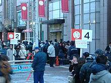
- Sendai New Year's traditional Sale on January 2
- Shiroishi Kokeshi Exhibition, May 3–5
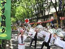
- Aoba Festival, Suzume Odori traditional Japanese dance event in May
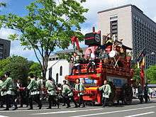
- Shiogama Port Festival in July
- Sendai Tanabata Festival, August 6–8
- Sendai Pageant of Starlight in December
Popular culture
Miyagi Prefecture is one of the main settings of Haikyū!!. The main places there are Karasuno High School, Aoba Johsai High School, and Shiratorizawa Academy, as well as Sendai City Gymnasium.
Notes
- Nussbaum, Louis-Frédéric. (2005). "Miyagi prefecture" in Japan Encyclopedia, p. 648, p. 648, at Google Books; "Tōhoku" in p. 970, p. 970, at Google Books.
- Nussbaum, "Sendai" in p. 841, p. 841, at Google Books.
- Nussbaum, "Provinces and prefectures" in p. 780, p. 780, at Google Books
- "Japan earthquake: Tsunami hits north-east". BBC News. March 11, 2011. Archived from the original on March 12, 2011.
- Williams, Martyn. "Report from Japan: Impact of Tsunami Devastates Nation's Northeast". voanews.com. Archived from the original on 9 January 2012. Retrieved 28 April 2018.
- "CBS News World". April 7, 2011. Archived from the original on 8 April 2011. Retrieved 7 April 2011.
- "Crown Prince Naruhito, Princess Masako visit tsunami victims in Miyagi". Japan Daily Press. Archived from the original on 2013-08-24. Retrieved 2013-08-22.
- 自然公園都道府県別面積総括 [General overview of area figures for Natural Parks by prefecture] (PDF) (in Japanese). Ministry of the Environment. Retrieved 13 August 2019.
- 宮城県の自然公園 [Natural Parks in Miyagi Prefecture] (in Japanese). Miyagi Prefecture. Retrieved 13 August 2019.
- Schreiber, Mark, "Japan's food crisis goes beyond recent panic buying Archived 2011-04-20 at the Wayback Machine", Japan Times, 17 April 2011, p. 9.
- Miyagi 1995-2020 population statistics
- Miyagi 1920-2000 population statistics
References
- Nussbaum, Louis-Frédéric and Käthe Roth. (2005). Japan encyclopedia. Cambridge: Harvard University Press. ISBN 978-0-674-01753-5; OCLC 58053128
- Titsingh, Isaac. (1834). Nihon Odai Ichiran; ou, Annales des empereurs du Japon. Paris: Royal Asiatic Society, Oriental Translation Fund of Great Britain and Ireland. OCLC 5850691
External links
| Wikimedia Commons has media related to Miyagi prefecture. |
- Miyagi Prefecture Official Website (in Japanese)
Sendai (capital) | |||
| Sendai |
| ||
| Cities | |||
| Districts |
| ||
| Authority control |
|
|---|