Ichihara, Chiba
Ichihara (市原市, Ichihara-shi) is a city located in Chiba Prefecture, Japan.
Ichihara 市原市 | |
|---|---|
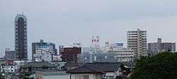 The skyline around Goi Station | |
 Flag  Seal | |
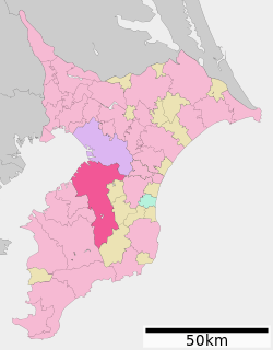 Location of Ichihara in Chiba Prefecture | |
 Ichihara | |
| Coordinates: 35°29′53″N 140°06′55.6″E | |
| Country | Japan |
| Region | Kantō |
| Prefecture | Chiba Prefecture |
| Government | |
| • Mayor | Joji Koide (since June 2015) |
| Area | |
| • Total | 368.17 km2 (142.15 sq mi) |
| Population (December 1, 2015) | |
| • Total | 275,776 |
| • Density | 749/km2 (1,940/sq mi) |
| Time zone | UTC+9 (Japan Standard Time) |
| Symbols | |
| • Tree | Ginkgo biloba |
| • Flower | Cosmos |
| • Bird | Japanese bush-warbler |
| Phone number | 0436-22-1111 |
| Address | 1-1-1 Kokubunjidai Chūō, Ichihara-shi, Chiba-ken 290-8501 |
| Website | http://www.city.ichihara.chiba.jp/ |
%E3%80%8D.jpg)
As of December 2015, the city has an estimated population of 275,776, and a population density of 749 persons per km2. The total area is 368.20 square kilometres (142.16 sq mi). The city is home, together with the city of Chiba, to the JEF United football club.
Geography
Ichihara is located in the western part of the Bōsō Peninsula, and geographically is the largest of Chiba Prefecture's cities and towns. The highly industrialized northern part of the city sits on Tokyo Bay, while the southern part of the city is primarily mountainous. Ichihara, dense in housing developments, serves as a satellite town of Tokyo and Chiba City.
History
The area of modern Ichihara is the center of ancient Kazusa province. The ruins of the Nara period Kazusa kokubun-ji have been found within the borders of Ichihara, although the exact location of the Nara-period provincial capital remains uncertain. During the Sengoku period, the area was contested between the Chiba clan to the north, and the Satomi clan to the south. During the Edo period, the area was divided between Goi Domain, Tsurumaki Domain and large areas of tenryō territory controlled directly by the Tokugawa shogunate and administered by various hatamoto.
City formation
- During the Meiji period, the area was reorganized into 171 villages under Ichihara District, Chiba Prefecture.
- By 1945, these villages had been consolidated into five towns and 16 villages.
- Through further consolidation and mergers, the city of Ichihara was founded on May 1, 1963.
- On October 1, 1967, the neighboring town of Nansō, and village of Kamo were merged into Ichihara.
2011 earthquake
On Friday, March 11, 2011, the city was struck by the Tōhoku earthquake. Natural gas storage tanks at the Cosmo oil refinery in Ichihara were set on fire by the earthquake.[1][2]
Economy
The city's economy is fueled by a large industrial complex overlooking Tokyo Bay. It contains the largest number of oil refineries in Japan, as well as power, petrochemical and shipbuilding companies.[3]
Crime and safety
The Soai-kai yakuza syndicate is headquartered in Ichihara.[4] A designated yakuza group, the Soai-kai is the three dominating yakuza syndicates in Chiba Prefecture, along with the Sumiyoshi-kai and the Inagawa-kai.[5]
Education
- Teikyo Heisei University
- Ichihara has 43 public and one private elementary school, 21 public middle schools and six public and two private high schools.
Transportation
Railway
- JR East – Uchibō Line
- Yawatajuku - Goi - Anegasaki
- Keisei Electric Railway – Keisei Chihara Line
- Kominato Railway – Kominato Line
- Goi - Kazusa-Murakami - Amaariki - Kazusa-Mitsumata - Kazusa-Yamada - Kōfūdai - Umatate - Kazusa-Ushiku - Kazusa-Kawama - Kazusa-Tsurumai - Kazusa-Kubo - Takataki - Satomi - Itabu - Tsukizaki - Kazusa-Ōkubo - Yōrōkeikoku
Sister city relations

Notable people from Ichihara
- Ikuo Suhoh - Show Biz Promoter
- Denjiro Yonemura - Science Entertainer
- Chiaki - Singer
- Neko Hiroshi - Marathon Runner
- Katsushige Kawashima - Boxer
- Hirotoshi Ishii - Baseball Player
- Kohei Kudo- Soccer Player
References
- "Japan earthquake causes oil refinery inferno". Daily Telegraph, London, 11 March 2011, Retrieved 11 March 2011
- "Natural gas storage tanks burn at Cosmo oil refinery in Ichihara city" Archived 2012-04-06 at the Wayback Machine. Reuters AlertNet. 11 March 2011, Retrieved 11 March 2011
- "An Outline of Ichihara City". Archived from the original on 2008-02-16. Retrieved 2008-03-23.
- "2010 Police White Paper Chapter 2 : Furtherance of Organized Crime Countermeasures", 2010, National Police Agency (in Japanese)
- "Condition of Boryokudan" Archived 2011-08-20 at the Wayback Machine, as of late 2010, Chiba Prefectural Police (in Japanese)
External links
| Wikimedia Commons has media related to Ichihara, Chiba. |
- Official Website (in Japanese)
Chiba (capital) | ||||
| Chiba |
| |||
| Core cities |
| |||
| Cities | ||||
| Districts | ||||
| 2,000,000 and more | |
|---|---|
| 1,000,000–1,999,999 | |
| 500,000–999,999 | |
| 200,000–499,999 |
|
| Authority control |
|
|---|