Lytton, Queensland
Lytton is an outer riverside suburb of the City of Brisbane, Queensland, Australia.[3] The historical region was a significant naval base after the establishment of Fort Lytton between 1880 and 1881. The Fort safeguarded the city and shipping routes from hostile invasions during the colonial period as Brisbane was close to the French naval garrison at Noumea.[4]
| Lytton Brisbane, Queensland | |||||||||||||||
|---|---|---|---|---|---|---|---|---|---|---|---|---|---|---|---|
 Fort Lytton with Brisbane River in background | |||||||||||||||
 Lytton | |||||||||||||||
| Coordinates | 27°25′23″S 153°09′03″E | ||||||||||||||
| Population | 6 (2011 census)[1] | ||||||||||||||
| Postcode(s) | 4178 | ||||||||||||||
| Location | 13 km (8 mi) from Brisbane GPO | ||||||||||||||
| LGA(s) | City of Brisbane (Wynnum Manly Ward)[2] | ||||||||||||||
| State electorate(s) | Lytton | ||||||||||||||
| Federal Division(s) | Bonner | ||||||||||||||
| |||||||||||||||
Geography
It is 13 kilometres (8.1 mi) north-east of the Brisbane CBD, but travel by the railway or road is considerably longer.[5]
History
A pilot station and a village were established at Lytton in 1859. It was most likely named after Edward Bulwer-Lytton (1803–73) who was the Colonial Secretary of State in 1858–59.[5] The layout of the village can be seen in an 1889 map.[6]
It would be two years before a road was surveyed from Norman Creek. A telegraph line was run from Brisbane to Lytton in 1862. During the years 1876–1908 a local post office was open.[5]
Due to Lytton's location on the south-east bank of the Brisbane River at its seaward end Fort Lytton was built in the 1881 to guard the mouth of the Brisbane River. The fort had a moat and was an pentagonal structure concealed behind an embankment. It was fortified with two six inch disappearing guns, also in 1881 a rifle range was added.[5]
At the 2011 census Lytton had a population of 6 people.[1]
Heritage listings
Lytton has a number of heritage-listed sites, including:
- Via South Street: Lytton Hill[7]
- 160 South Street: Fort Lytton[8]
- 160 South Street: former Lytton Quarantine Station[9]
Present day
Although Lytton was once a town, it is now primarily commercial and industrial. It shares the same postcode as the Port of Brisbane. Ampol owns and operates the Lytton oil refinery in the north east of the suburb. The plant could produce 109,000 barrels per day in 2012.[10]
Gallery
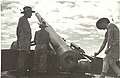 1943-11-11. Gun drill at Lytton. Left to right H. G. Brigg, A. T. Llewellan, B. F. Williams.
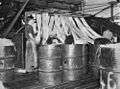 Rope works on Lytton road.
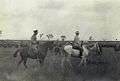 Lord Chelmsford inspecting the Light Horse camp at Lytton, April 1908
See also
References
- Australian Bureau of Statistics (31 October 2012). "Lytton (State Suburb)". 2011 Census QuickStats. Retrieved 24 October 2013.

- "Wynnum Manly Ward". Brisbane City Council. Brisbane City Council. Retrieved 12 March 2017.
- "Lytton (entry 43599)". Queensland Place Names. Queensland Government. Retrieved 2 September 2015.
- "Culture and History". Queensland Government Parks and Forests.
- Queensland places
- "Brisbane River Improvements sheet 2". Queensland Government (Map). 1889. Archived from the original on 17 July 2020. Retrieved 17 July 2020.
- "Lytton Hill (entry 601366)". Queensland Heritage Register. Queensland Heritage Council. Retrieved 6 July 2013.
- "Fort Lytton (entry 600248)". Queensland Heritage Register. Queensland Heritage Council. Retrieved 6 July 2013.
- "Lytton Quarantine Station (former) (entry 601347)". Queensland Heritage Register. Queensland Heritage Council. Retrieved 6 July 2013.
- Jessica Jaganathan (22 February 2012). "Caltex Australia to shut crude unit at Lytton refinery in H1". reuters.com. Thomson Reuters. Retrieved 14 February 2015.
External links
| Wikimedia Commons has media related to Lytton, Queensland. |
- University of Queensland: Queensland Places: Lytton
- "Lytton Defence Reserve | Fort Lytton Historic Military Precinct". fortlytton.org.au. Retrieved 13 August 2016.