Lota, Queensland
Lota is an eastern outer coastal suburb in the City of Brisbane, Queensland, Australia.[3]
| Lota Brisbane, Queensland | |||||||||||||||
|---|---|---|---|---|---|---|---|---|---|---|---|---|---|---|---|
 Moreton Bay and foreshore reserve, 2014 | |||||||||||||||
| Population | 3,256 (2016 census)[1] | ||||||||||||||
| Postcode(s) | 4179 | ||||||||||||||
| Location | 17 km (11 mi) from Brisbane GPO | ||||||||||||||
| LGA(s) | City of Brisbane (Wynnum Manly Ward)[2] | ||||||||||||||
| State electorate(s) | Lytton | ||||||||||||||
| Federal Division(s) | Bonner | ||||||||||||||
| |||||||||||||||
Geography
Lota is 16 kilometres (9.9 mi) east of the CBD. The suburb is of primarily post-war residential make-up but is gradually being developed with modern beachside properties.
History

This part of Moreton Bay was originally occupied by the semi-nomadic Mipirimm people of Quandamooka.
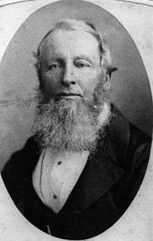
Most of the land of Lota was acquired by early settler Irish-born William Duckett White in 1862, following sub-division of the lands from Lytton to Fig Tree Point (Lota). The suburb is named after White's house 'Lota House', built in 1863.[4]
St Agnes' Anglican Church on The Esplanade (near Orallo Street, approx 27.4682°S 153.19269°E) was dedicated on 16 May 1957 by Archbishop Halse.[5] Its closure was approved on 21 January 1994 by Assistant Bishop Ron Williams. The building was moved to Alexandra Hills Parish.[6]
In the 2011 census, Lota recorded a population of 3,255 people.[7]
Heritage listings

Lota has one heritage-listed site.
- 162 Oceana Terrace: Lota House, the residence of William Duckett White, Member of the Queensland Legislative Council[8]
Geography
The south and east of the suburb is dominated by the mudflats and mangrove wetlands of Lota Creek and Moreton Bay. To the west and north, the land rises towards the heights of Manly and Manly West.
Transport
Lota railway station provides access to regular Queensland Rail City network services to Brisbane and Cleveland. In 1960, the railway line between Lota and Cleveland was closed, leaving Lota as the terminal until re-opening of the line in stages between 1983 and 1987.
Attractions
Lota is home to several key amenities, including Bayside PCYC, Bayside United Soccer Club, Lota State School and Melaleuca Environmental Park. The Lota Foreshore Park (Lota Camping Reserve) is a large bay-front park that stretches along the eastern edge of the suburb, with playgrounds, barbecuing facilities, boat ramps and a sculpture park. A boardwalk crosses Lota Creek from Whites Road to Chelsea Road in Ransome.
Governance
At the local level, Lota is in the Wynnum-Manly ward of the Brisbane City Council, represented by Cr Peter Cumming since March 1994. At the state level, Lota is within the Lytton electorate, a traditionally safe Labor seat, held by Joan Pease. LNP MP Ross Vasta has held the Federal electorate of Bonner since 2010.
Education
Lota State School was opened on 29 January 1952.
Demographics
In the 2011 census, Lota recorded a population of 3,255 people, 50.6% female and 49.4% male.[7] The median age of the Lota population was 38 years of age, 1 year above the Australian median. 74.9% of people living in Lota were born in Australia, compared to the national average of 69.8%; the next most common countries of birth were England 7.8%, New Zealand 4.9%, South Africa 1.2%, Scotland 0.9%, Ireland 0.7%. 92.9% of people spoke only English at home; the next most common languages were 0.4% German, 0.3% French, 0.2% Punjabi, 0.2% Japanese, 0.2% Italian.[7]
References
- Australian Bureau of Statistics (27 June 2017). "Lota (State Suburb)". 2016 Census QuickStats. Retrieved 14 April 2018.

- "Wynnum Manly Ward". Brisbane City Council. Brisbane City Council. Retrieved 12 March 2017.
- "Lota (entry 43245)". Queensland Place Names. Queensland Government. Retrieved 22 September 2015.
- Myrtle Beitz (2005) Mangroves to Moorings Revisited: A History of the Wynnum, Manly and Lota District
- Universal Business Directories (Aust.) Pty. Ltd (1990). UBD street directory. Brisbane. Universal Business Directories (Australia). pp. 15, Map 22 O6.
- "Closed Churches". Anglican Church Southern Queensland. Archived from the original on 3 April 2019. Retrieved 25 February 2019.
- Australian Bureau of Statistics (31 October 2012). "Lota, Qld (State Suburb)". 2011 Census QuickStats. Retrieved 24 October 2013.
- "Lota House - Edwin Marsden Tooth Memorial Home (entry 600247)". Queensland Heritage Register. Queensland Heritage Council. Retrieved 6 July 2013.
External links
| Wikimedia Commons has media related to Lota, Queensland. |