List of State Register of Heritage Places in the City of Greater Geraldton
This is a list of State Register of Heritage Places in the City of Greater Geraldton, Western Australia. The State Register of Heritage Places is maintained by the Heritage Council of Western Australia.
As of 2020, 733 places are heritage-listed in the City of Greater Geraldton,[1] of which 84 are on the State Register of Heritage Places.[2]
List
The Western Australian State Register of Heritage Places, as of 2020, lists the following 84 state registered places within the City of Greater Geraldton:
| Place name | Place # | Location | Suburb or town | Co-ordinates | Built | Stateregistered | Notes | Photo |
|---|---|---|---|---|---|---|---|---|
| Masonic Lodge, Geraldton | 1046 | 126 Augustus Street | Geraldton | 28°46′52″S 114°36′24″E | 1892 | 24 September 2004 |
| |
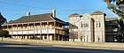
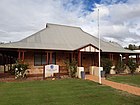
| Bill Sewell Community Recreation Complex | 1048 | Corner Chapman Road & Bayly Street | Geraldton | 28°46′07″S 114°36′55″E | 1887 | 10 October 1995 |
|  |
| Birdwood House, Geraldton | 1049 | 44 & 46 Chapman Road | Geraldton | 28°46′18″S 114°36′47″E | 1935 | 18 November 2016 |
|  |
| The Hermitage | 1051 | Onslow Street & Cathedral Avenue | Geraldton | 28°47′08″S 114°36′53″E | 1936 | 9 September 2011 |
| |
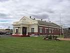
| Geraldton railway station (former) | 1052 | 75 & 79 Chapman Road | Geraldton | 28°46′18″S 114°36′47″E | 1915 | 15 May 1998 |
|  |
| Nazareth House | 1055 | Crowtherton Street | Bluff Point | 28°43′45″S 114°37′22″E | 1941 | 20 February 2004 |
|  |
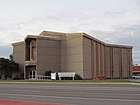
| Geraldton Town Hall (former) | 1058 | 22-24 Chapman Road | Geraldton | 28°46′24″S 114°36′41″E | 1907 | 12 December 1997 |
|  |
| Radio Theatre Building | 1060 | 205-209 Marine Terrace | Geraldton | 28°46′31″S 114°36′25″E | 1937 | 16 December 2003 |
| |
| Community Education Centre, Geraldton | 1061 | 24 Gregory Street | Geraldton | 28°46′38″S 114°36′20″E | 1874 | 15 October 2004 |
| |
| Geraldton Police Barracks (former) | 1062 | 205-215 Lester Avenue | Geraldton | 28°46′36″S 114°36′21″E | 1912 | 1 October 2002 |
| |
| St John's Uniting Church (former) | 1063 | 225-227 Lester Avenue | Geraldton | 28°46′36″S 114°36′30″E | 1893 | 21 January 1997 |
|  |
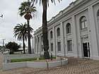
| St Francis Xavier Cathedral | 1064 | Corner Cathedral Avenue & Maitland Street | Geraldton | 28°46′39″S 114°36′43″E | 1938 | 10 October 1995 |
|  |
| Geraldton Drill Hall | 1065 | Corner Lester & Cathedral Avenue | Geraldton | 28°46′32″S 114°36′36″E | 1935 | 20 February 2004 |
| |
| Original Railway Station (1878–93), Geraldton | 1068 | 246 Marine Terrace | Geraldton | 28°46′32″S 114°36′20″E | 1878 | 7 April 1998 |
| |
| Geraldton Club | 1069 | 160-66 Marine Terrace | Geraldton | 28°46′28″S 114°36′29″E | 1912 | 30 June 2009 |
| |
| Mission to Seamen Building | 1071 | 272 Marine Terrace | Geraldton | 28°46′35″S 114°36′16″E | 1864 | 27 February 2004 |
| |
| Geraldton Court House | 1072 | Corner Marine Terrace & Forrest Street | Geraldton | 28°46′16″S 114°36′43″E | 1898 | 7 January 2000 |
| |
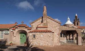
| Chapel of San Spirito | 1073 | 130 Utakarra Road | Utakarra | 28°46′41″S 114°38′35″E | 1936 | 10 October 1995 |
| |
| Geraldton Lighthouse Tower & Quarters | 1074 | 353-355 Chapman Road | Bluff Point | 28°44′37″S 114°37′17″E | 1876 | 9 July 1993 |
|  |
| Greenough Pioneer Cemetery | 1133 | Brand Highway | Greenough | 28°56′02″S 114°44′20″E | 1853 | 24 March 2000 |
| |
| Corringle | 1134 | Brand Highway | Greenough | 28°54′08″S 114°41′56″E | 1898 | 19 January 2007 |
| |
| Dominican Convent (former) | 1142 | 62 Gregory Road | Greenough | 28°56′37″S 114°44′39″E | 1898 | 9 July 1993 |
| |
| Greenough Hotel (former) | 1143 | 9 Gregory Road | Greenough | 28°56′11″S 114°44′27″E | 1868 | 9 July 1993 |
| |
| St James' Anglican Church, South Greenough | 1145 | 33583 Brand Highway | Greenough | 29°00′16″S 114°47′48″E | 1872 | 29 October 2010 |
| |
| Clinch's Mill | 1146 | Gregory Road | Greenough | 28°56′18″S 114°44′28″E | 1857 | 9 July 1993 |
| |
| Hampton Arms | 1151 | Company Road | Greenough | 28°57′50″S 114°45′05″E | 1863 | 22 January 2002 |
| |
| Old Store | 1152 | 91 Gregory Road | Greenough | 28°56′39″S 114°44′43″E | 1886 | 9 July 1993 |
| |
| Gray's Store | 1153 | Corner Company & McCartney Roads | Greenough | 28°57′09″S 114°44′16″E | 1861 | 9 July 1993 |
|  |
| Cliff Grange Farmhouse | 1154 | Gregory Road | Greenough | 28°56′20″S 114°44′32″E | 1870 | 9 July 1993 |
| |
| Central Greenough School Building | 1156 | Gregory Road | Greenough | 28°56′37″S 114°44′40″E | 1865 | 9 July 1993 |
| |
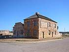
| Greenough Court House, Police Station and Gaol | 1157 | Gregory Road | Greenough | 28°56′35″S 114°44′39″E | 1866 | 9 July 1993 |
| |
| Priest's House (former) | 1158 | Gregory Road | Greenough | 28°56′36″S 114°44′37″E | 1900 | 9 July 1993 |
| |
| Greenough Road Board Office (former) | 1159 | Gregory Road | Greenough | 28°56′33″S 114°44′36″E | 1906 | 14 December 2001 |
| |
| St Catherine's Anglican Church Hall | 1160 | 39 Gregory Road | Greenough | 28°56′32″S 114°44′36″E | 1898 | 9 July 1993 |
| |
| St Catherine's Anglican Church | 1161 | Gregory Road | Greenough | 28°56′32″S 114°44′36″E | 1913 | 14 December 2001 |
| |
| St Peter's Catholic Church | 1162 | Gregory Road | Greenough | 28°56′38″S 114°44′39″E | 1908 | 2 September 1997 |
| |
| St Joseph's School (former) | 1164 | Gregory Road | Greenough | 28°56′37″S 114°44′38″E | 1891 | 9 July 1993 |
| |
| Maley's Mill | 1165 | Phillips Road | Greenough | 28°54′56″S 114°42′35″E | 1861 | 24 November 2000 |
| |
| Maley's Bridge | 1166 | McCartney Road | Greenough | 28°56′55″S 114°44′31″E | 1864 | 16 July 1993 |
| |
| Wesley Methodist Chapel (former) | 1167 | 524 Company Road | Greenough | 28°57′08″S 114°44′16″E | 1867 | 15 October 1999 |
| |
| Holy Trinity Anglican Church | 1168 | Lot 13 Walkaway-Nangetty Road | Walkaway | 28°56′26″S 114°48′44″E | 1903 | 23 November 2004 |
| |
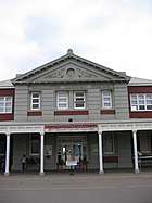
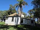
| Walkaway Railway Station Museum | 1170 | 34Padbury Road | Walkaway | 28°56′21″S 114°48′06″E | 1888 | 15 October 1999 |
| 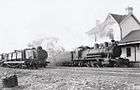 |
| Geraldton to Walkaway Railway Precinct | 1259 | Railway Line Route between Bluff Point and Narngulu | Geraldton | N/A | 1886 | 9 December 2011 |
| |
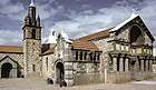
| Church of Our Lady of Mount Carmel & Holy Apostles St Peter & St Paul & Priest House | 1656 | Corner Bowes & Doney Streets | Mullewa | 28°32′20″S 115°31′04″E | 1915 | 10 October 1995 |
|  |
| Priest House | 1657 | Bowes Street | Mullewa | 28°32′20″S 115°31′04″E | 1927 |
|  | |
| Masonic Lodge (former), Mullewa | 1662 | 43 Jose Street | Mullewa | 28°32′18″S 115°30′42″E | 1926 | 28 September 2012 |
| .jpg) |
| Pindar Garage Buildings | 1668 | Sharpe Street | Pindar | 28°28′39″S 115°47′19″E | 1926 | 21 April 2006 |
| |
| Pindar Hotel (former) | 1669 | 17 Sharpe Street | Pindar | 28°28′37″S 115°47′26″E | 1905 | 23 April 1999 |
| |
| Christian Brothers' Agricultural School Group | 1672 | Kelly Road | Tardun | 28°42′11″S 115°48′58″E | 1936 | 5 January 2001 |
| |
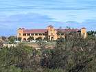
| Pallottine Monastery | 1673 | 739 Pallotine Road | Tardun | 28°47′14″S 115°50′37″E | 1938 | 17 March 2006 |
| |
| Newmarracarra | 3443 | 1853 Geraldton-Mount Magnet Road | Bringo | 28°43′10″S 114°49′32″E | 1910 | 7 October 1997 |
| |
| Rosella House | 3458 | 11 Bayly Street | Geraldton | 28°46′06″S 114°37′00″E | 1912 | 9 May 1997 |
| |
| Geraldton Residency | 3715 | 321 Marine Terrace | Geraldton | 28°46′41″S 114°36′09″E | 1861 | 7 April 1998 |
| |
| Glengarry Station Complex | 3726 | Glengarry Road | Moonyoonooka | 28°49′43″S 114°49′29″E | 1850 | 4 May 2001 |
| |
| Old Greenough Post Office (site of) | 3728 | Gregory Road | Greenough | 28°56′37″S 114°44′40″E | 1930 |
| ||
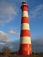
| Point Moore Lighthouse | 3927 | 45 Marine Terrace | West End | 28°46′58″S 114°34′46″E | 1878 | 4 May 2001 |
|  |
| Geraldton Customs House Complex | 3940 | 7 & 9 Francis Street | Geraldton | 28°46′38″S 114°36′15″E | 1935 | 23 April 1999 |
| |
| Sandsprings Homestead Group | 3944 | 325 Sandsprings Road | Sandsprings | 28°48′02″S 114°58′14″E | 1868 | 29 June 2010 |
| |
| St James Chapel, Kojarena | 3958 | Kojarena South Road | Geraldton | 28°44′26″S 114°52′17″E | 1935 | 31 July 2007 |
| |
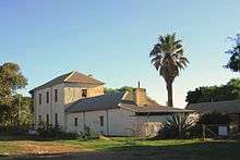
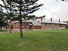
| Pioneer Museum, Greenough | 4285 | 1 Phillips Road | Greenough | 28°54′55″S 114°42′37″E | 1862 | 22 November 2002 |
|  |
| Tibradden Homestead Group | 4630 | 1318 Sandsprings Road | Tibradden | 28°45′06″S 114°54′16″E | 1850 | 24 January 2014 |
| |
| Butterabby Graves | 5109 | Devil's Creek Road/Butterabby Road | Devil's Creek | 28°41′06″S 115°29′53″E | 1864 | 31 March 2006 |
| |
| Presentation Convent (former) | 5112 | Doney Street | Mullewa | 28°32′20″S 115°31′04″E | 1915 |
|  | |
| Mullewa Railway Station Group | 6105 | 40 Maitland Road | Mullewa | 28°32′34″S 115°30′41″E | 1894 | 31 March 2006 |
| .jpg) |
| Narra Tarra Homestead, Outbuildings & Cemetery | 6353 | 982 Narra Tarra-Moonyoonooka Road | Narra Tarra | 28°41′22″S 114°44′07″E | 1853 | 9 September 2003 |
| |
| Railway Gatekeeper's Cottage (former) | 11054 | Short Road | Walkaway | 28°55′21″S 114°47′01″E | 1886 |
| ||
| Geraldton District Honour Roll, Birdwood House | 12422 | Corner Chapman Road & Forrest Street | Geraldton | 28°46′18″S 114°36′47″E | 1930 |
| ||
| Moonyoonooka State School Roll of Honour, Birdwood House | 12516 | Corner Chapman Road & Forrest Street | Geraldton | 28°46′18″S 114°36′47″E | 1930 |
| ||
| Trefusis, Chapman & Jose Factory (former) | 13200 | 132 Augustus Street | Geraldton | 28°46′46″S 114°36′22″E | 1886 | 15 October 2004 |
| |
| Anglican Cathedral of the Holy Cross, Geraldton | 13227 | Cathedral Avenue | Geraldton | 28°46′44″S 114°36′52″E | 1964 | 25 June 2004 |
|  |
| Old Geraldton Gaol & Warder's Cottages | 13240 | 84 Chapman Road | Geraldton | 28°46′07″S 114°36′55″E | 1859 |
| ||
| Railway Cottage (former), Bluff Point & Two Mile Well | 13253 | 300 & 308 Chapman Road | Beresford | 28°44′53″S 114°37′12″E | 1886 | 12 November 2004 |
| |
| Railway House (former), Utakarra | 13373 | Lot 2710 Eastward Road | Utakarra | 28°46′38″S 114°38′52″E | 1893 |
| ||
| Geraldton Primary School | 13390 | 75 Fitzgerald Street | Geraldton | 28°46′43″S 114°36′28″E | 1878 | 18 May 2004 |
|  |
| Belay Farm Group, Walkaway | 13900 | Evans Road | Walkaway | 28°56′02″S 114°46′35″E | 1858 | 29 June 2010 |
| |
| Walkaway CWA Rooms | 13926 | 5 Evans Road | Walkaway | 28°56′25″S 114°48′03″E | 1959 | 14 February 2003 |
| |
| Windarra, Moonyoonooka | 13929 | 34 Glengarry Road | Moonyoonooka | 28°46′54″S 114°45′22″E | 1863 | 17 January 2012 |
| |
| Koogereena Homestead | 13930 | Kojarena Road South | Kojarena | 28°44′36″S 114°51′53″E | 1911 | 20 January 2006 |
| |
| Yanget Station Group, Kojarena | 13931 | 330 Yanget Road | Kojarena | 28°41′39″S 114°52′00″E | 1910 | 3 February 2020 |
| |
| Railway Goods Shed | 25458 | Maley Street | Mullewa | 28°32′34″S 115°30′41″E |
| |||
| Railway Water Tank & Column | 25459 | 19 Darlot Road | Mullewa | 28°32′34″S 115°30′41″E |
| |||
| St Mary's Chapel - Christian Brother's Agricultural School | 25464 | 970 Kelly Road | Tardun | 28°42′11″S 115°48′58″E |
| |||
| St Mary's Convent - Christian Brothers' Agricultural School | 25465 | 970 Kelly Road | Tardun | 28°42′11″S 115°48′58″E |
| |||
| Pindar Garage Residence | 25466 | 3 Sharpe Street | Pindar | 28°28′39″S 115°47′19″E |
|
References
- "City of Greater Geraldton Heritage Places". inherit.stateheritage.wa.gov.au. Heritage Council of Western Australia. Retrieved 23 March 2020.
- "City of Greater Geraldton State Register of Heritage Places". inherit.stateheritage.wa.gov.au. Heritage Council of Western Australia. Retrieved 23 March 2020.
This article is issued from Wikipedia. The text is licensed under Creative Commons - Attribution - Sharealike. Additional terms may apply for the media files.